Gerbstedt
| Gerbstedt | ||
|---|---|---|
| ||
 Gerbstedt | ||
Location of Gerbstedt within Mansfeld-Südharz district 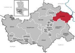 | ||
| Coordinates: 51°37′59″N 11°37′0″E / 51.63306°N 11.61667°ECoordinates: 51°37′59″N 11°37′0″E / 51.63306°N 11.61667°E | ||
| Country | Germany | |
| State | Saxony-Anhalt | |
| District | Mansfeld-Südharz | |
| Government | ||
| • Mayor | Siegfried Schwarz (CDU) | |
| Area | ||
| • Total | 102.28 km2 (39.49 sq mi) | |
| Population (2015-12-31)[1] | ||
| • Total | 7,462 | |
| • Density | 73/km2 (190/sq mi) | |
| Time zone | CET/CEST (UTC+1/+2) | |
| Postal codes | 06347 | |
| Dialling codes | 03476, 034773, 034783 | |
| Vehicle registration | MSH, EIL, HET, ML, SGH | |

| Wikimedia Commons has media related to Gerbstedt. |
Gerbstedt is a small town in Saxony-Anhalt, district Mansfeld-Südharz. By tradition it was the town of copper miners and tanners (in German Gerber), which gave the name for the town.

Tower of former monastery Gerbstedt
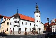
Town hall Gerbstedt

View of Gerbstedt with a rare Robur bus
Location
The town Gerbstedt is located 9 km (5.59 mi) west of Hettstedt and 13 km (8.08 mi) north of the town Eisleben.
Parts of the town
The following Ortsteile (Town subdivisions) are parts of the town Gerbstedt:
Sons and daughters of the town
- Otto Brosowski (1885-1947), mining worker, KPD member
- Eugen Ray (1957-1986), athlete
Other persons associated with Gerbstedt

Friedrich Gottlieb Klopstock around 1779
- Rikdag, (died 985), Margrave of Meißen
- Friedrich Gottlieb Klopstock, (1724-1803), poet, spent his youth in Friedeburg
Towns and municipalities in the district of Mansfeld-Südharz | ||
|---|---|---|
References
- ↑ "Bevölkerung der Gemeinden – Stand: 31.12.2015" (PDF). Statistisches Landesamt Sachsen-Anhalt (in German).
This article is issued from Wikipedia - version of the 11/8/2016. The text is available under the Creative Commons Attribution/Share Alike but additional terms may apply for the media files.