Gerald Desmond Bridge
| Gerald Desmond Bridge | |
|---|---|
|
The 1968 Gerald Desmond Bridge spans the Back Channel, connecting Long Beach with Terminal Island. | |
| Coordinates | 33°45′52″N 118°13′16″W / 33.76444°N 118.22111°WCoordinates: 33°45′52″N 118°13′16″W / 33.76444°N 118.22111°W |
| Carries |
4 lanes of Ocean Blvd between |
| Crosses | Back Channel |
| Locale | Terminal Island and Long Beach, California |
| Named for | Gerald Desmond |
| Owner | Port of Long Beach |
| NBI | 53C0065 |
| Preceded by | 1944 pontoon bridge |
| Followed by | 2018 cable-stayed span |
| Characteristics | |
| Design | through arch bridge |
| Material | Steel |
| Total length | 5,134 ft (1,565 m) |
| Longest span | 410 ft (125 m) |
| Piers in water | 2 |
| Clearance below | 155 ft (47 m) |
| History | |
| Construction begin | October 19, 1965 |
| Construction end | 1968 |
| Construction cost | US$615,000,000 (equivalent to $4,192,000,000 in 2015) |
| Rebuilt | 1995–2000 |
| Closed | 2018 (scheduled) |
| Replaces | 1944 pontoon bridge |
| Replaced by | 2018 cable-stayed span |
| Statistics | |
| Daily traffic | 62,057 (2012) |
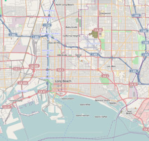 Gerald Desmond Bridge Location in Long Beach, California | |
| Gerald Desmond Bridge (new bridge) | |
|---|---|
 Rendering of the replacement bridge | |
| Carries |
6 lanes of |
| Crosses | Back Channel |
| Locale | Terminal Island and Long Beach, California |
| Characteristics | |
| Design | Cable-stayed bridge |
| Total length | 8,800 ft (2,682 m) |
| Height | 515 ft (157 m) |
| Longest span | 1,000 ft (305 m) |
| Clearance below | 205 ft (62 m) |
| History | |
| Construction begin | 2013 |
| Construction cost | est. US$1,500,000,000 |
| Opened | 2018 (scheduled) |
The Gerald Desmond Bridge is a through arch bridge that carries four lanes of Ocean Boulevard from Interstate 710 in Long Beach, California, west across the Back Channel to Terminal Island. The bridge is named after Gerald Desmond, a prominent civic leader and a former city attorney for the City of Long Beach.
History
Prior to 1944, the only road access to Terminal Island was via Badger Avenue (later Henry Ford Avenue, after an assembly plant that was built on the island) over the Henry Ford Bridge.
1944 pontoon bridge
The first bridge linking the eastern end of Terminal Island and Long Beach was an unnamed "temporary" pontoon bridge constructed during World War II to accommodate traffic resulting from the expansion of the Long Beach Naval Shipyard. The pontoon bridge was intended to last six months, but was not replaced until 1968, 24 years after it had opened. Depending on the level of the tide, road traffic had to descend 17 to 25 feet (5.2 to 7.6 m) below the level on the shore. When marine traffic required the bridge to open, traffic delays of up to 15 minutes could occur.[1] An estimate of seven people died after driving off the pontoon bridge.[1][2]
1968 through-arch
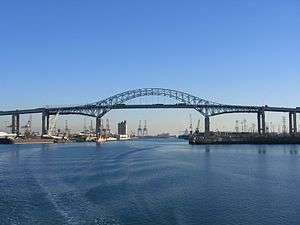
The 1968 through-arch bridge was designed by Moffatt & Nichol[3] Engineers and was constructed by Bethlehem Steel as a replacement for the World War II-era pontoon bridge. Gerald Desmond served as City Attorney for Long Beach and played a significant role in obtaining tideland oil funds which helped finance the bridge that would later bear his name. Desmond died in office at age 48 of kidney cancer.[4] One year after Desmond's death in January 1964, ground-breaking for the construction of the new bridge occurred on October 19, 1965, and it was completed in 1968. Desmond's son, also named Gerald, sank the final "golden" bolt.[4] It has a 410-foot-long (120 m) suspended main span and a 155-foot (47 m) vertical clearance over the Cerritos Channel and connects Terminal Island on its east side to downtown Long Beach. The bridge separates the inner harbor from the middle harbor.
At the time of its completion in 1968, traffic was projected to be modest and mainly limited to workers commuting to jobs at the Long Beach Naval Shipyard. When the Long Beach NSY was closed in 1997, that land was converted and served as home to one of the busiest container terminals in the United States, resulting in greater cargo truck and marine traffic. By some estimates, truck traffic across the bridge tripled in the years following the closure of the Long Beach NSY.[5] By 2010, the 155-foot (47 m) vertical clearance of the 1968 bridge was one of the lowest for a commercial seaport, especially at the Port of Long Beach, which remains one of the busiest container ports in the United States.[6] In addition, the bridge was not designed for the traffic it carried (62,000 vehicles in 2012), and the added stress was causing pieces of concrete to fall from the bridge's underside, forcing the Port of Long Beach to install nylon mesh "diapers" in 2004 to catch these chunks.[5] Also, since the 1968 bridge roadway lacks emergency/breakdown lanes, multiple lanes would be shut down in the event of an accident, snarling traffic.[7] Other deficiencies cited include the steep approach grades (5.5 percent on the west side and 6 percent on the east side)[8]
Competition in the marine shipping industry meant boosting shipping efficiency by building ever-larger container ships. The Gerald Desmond Bridge became a barrier for ships entering the Inner Harbor at Long Beach, with its restrictive 155-foot (47 m) vertical clearance resulting in a drop in its share of United States container imports by 2013. According to U.S. census data, the ports of Long Beach and Los Angeles handled 32% of U.S. container imports in 2013, down from 39% in 2002.[9] In March 2012, the insufficient vertical clearance of the bridge prevented passage of the 12,562 TEU MSC Fabiola, the largest container ship ever to enter the Port of Long Beach. The height restriction prevented the ship from docking at the Mediterranean Shipping Company (MSC) dock; it docked at the Hanjin terminal instead.[10]
2018 cable-stayed replacement
The 1968 steel arch bridge developed numerous issues (detailed above), and the Port of Long Beach suggested it would be more economical to replace the bridge. After several years of studies, a cable-stayed bridge with 205 feet (62 m) of vertical clearance to be built north of the existing bridge was identified as the preferred alternative in the final environmental impact report (2010 FEIR).[8] The new bridge will allow access to the port for the tallest container ships, and will be the first long-span cable-stayed bridge in California.[11] For the bridge to be so tall, long approaches will be required to allow trucks to cross.[12] A joint venture of Parsons Transportation Group and HNTB performed preliminary engineering for the main span and the approaches. Earlier reports had studied and discarded various alternatives, including an alternative alignment with a new bridge south of the existing bridge, rehabilitation of the existing bridge, and a tunnel instead of an elevated bridge.[8]
Ocean Boulevard, currently carried by the 1968 bridge, is operated by the City of Long Beach. When the replacement bridge is completed, the roadway it carries will be redesignated the western extension of I-710, extending to its intersection with State Route 47, and it will become the responsibility of Caltrans, District 7.[13] The current roadway is four lanes (two in each direction) with a fifth climbing lane on each end. The replacement bridge will carry a six-lane roadway with emergency lanes on each side, and the grade will decrease by building a longer approach, despite the higher vertical clearance over the Back Channel; the planned improvements will bring the bridge up to current freeway standards.[13] The replacement bridge will also carry a pedestrian/bike path and observation decks over the water along the south side of the bridge. The path is named for Mark Bixby, a longtime proponent of adding bike lanes to the replacement for the Gerald Desmond Bridge[14][15] and a descendant of one of the original founders of Long Beach. Mark Bixby died in a March 2011 plane crash at the Long Beach Airport.[16]
.jpg)
The replacement bridge was unanimously approved by the City of Long Beach in late September 2010.[17] A project launch meeting was held at the Port of Long Beach on November 22, 2010, attended by Long Beach Mayor Bob Foster, U.S. Representatives Dana Rohrabacher and Laura Richardson, Senator Alan Lowenthal and Caltrans Director Cindy McKim.[13] In 2012, the Long Beach Board of Harbor Commissioners approved Port of Long Beach staff’s recommendation that the “best value” design-build proposal to replace the Gerald Desmond Bridge was submitted by the SFI joint venture team, comprising Shimmick Construction Company Inc., FCC Construction S.A. and Impregilo S.p.A., and the contract was awarded to the SFI JV in July 2012.[18] Major participants in the joint venture also include Arup North America Ltd. and Biggs Cardosa Associates Inc.[19] During the groundbreaking ceremony on January 8, 2013, two helicopters hovered 515 feet (157 m) above ground level, illustrating the height of the two cable towers for the planned replacement bridge.[20]
The project was originally estimated to cost $800 million in 2008.[21] By 2010, costs had increased to $1.1 billion,[17] and funding identified in 2010 for the replacement bridge included $500 million contributed by Caltrans, $300 million contributed by the USDOT, $114 million from the Port of Long Beach, and $28 million from Metro.[13] As of 2016, the current project estimate is $1.5 billion,[11] and it is scheduled for completion by 2018. Part of the cost increase is attributed to a 2013 redesign of the support towers. Caltrans and the Port of Long Beach required the SFI joint venture to redesign the towers to ensure seismic safety and to preserve long term structural integrity. Other cost increases are attributed to extra oversight required by innovative products and materials proposed by the designers of the replacement bridge.[11]
The project is to be completed as a design-build in contrast to the traditional design-bid-build used typically in infrastructure improvement. As of 2015, construction on the replacement bridge is still underway.[19] Highway spans are now underway.
From west to east, the new bridge will span a total of 8,800 feet (2,700 m), consisting of:[22]
- The 2,800 ft (850 m) West Approach (3,117 ft (950 m) in the 2010 FEIR)
- The 2,000 ft (610 m) cable-stayed span, with a 1,000 ft (300 m) Main Span flanked by two 500 ft (150 m) Back Spans
- The 3,600 ft (1,100 m) East Approach (3,035 ft (925 m) in the 2010 FEIR)
By extending the approach structures, approach grades are reduced to no more than 5 percent.[8]
As the tallest structure in the area, the 2018 cable-stayed bridge will be a prominent addition to the Long Beach skyline. Brian Ulaszewski has criticized the proposed bridge as being "generic" and lacking "the dynamism and elegance appropriate for what will be the tallest bridge in Southern California."[23] Ulaszewski cited two recently-completed pedestrian bridges, the da Vinci Bridge in Norway and the Sundial Bridge in Redding, as bridges with inspired designs.
Popular culture
The 1944 pontoon bridge was featured in a chase scene appearing in the 1963 film It's a Mad, Mad, Mad, Mad World.[1][24]
The 1968 arch bridge had a featured role in the film Head, featuring rock group The Monkees, released in 1968. The first scene of the film features the actual dedication ceremony for the bridge, which is interrupted by the Monkees running into the middle of the ceremony and Micky Dolenz jumping off the bridge. At the conclusion of the film, the Monkees return to the bridge and each of them jumps from it.
An unnamed bridge based on the 1968 arch bridge is also featured in the video game Grand Theft Auto V. It carries the "Elysian Fields Freeway" in the game.
_from_north_looking_south-southeast_crop.jpg)
See also
-
 Bridges portal
 -
 California portal
 - Vincent Thomas Bridge
References
- 1 2 3 Harvey, Steve (3 October 2010). "Bridge is afloat on the pages of history". Los Angeles Times. Retrieved 21 November 2016.
- ↑ Waldie, D. J. (3 June 2013). "The Bridges of Terminal Island". KCET. Retrieved 21 November 2016.
- ↑ Husky, Brian. "Rail & Bridge Services". M&N.
- 1 2 Haldane, David (20 June 1985). "Son of a Bridge, If It Isn't Gerald Desmond". Los Angeles Times. Retrieved 21 November 2016.
- 1 2 Daniels, Cynthia (25 March 2004). "Terminal Island Cargo Has Outgrown Old Bridge". Los Angeles Times. Retrieved 21 November 2016.
- ↑ Ceasar, Stephen (23 November 2010). "Long Beach bridge at the end of its lifespan". Los Angeles Times. Retrieved 21 November 2016.
- ↑ White, Ronald D. (5 February 2010). "Plan to replace bridge at Port of Long Beach progresses". Los Angeles Times. Retrieved 21 November 2016.
- 1 2 3 4 Parsons–HNTB Joint Venture (July 2010). Gerald Desmond Bridge Replacement Project: Final Environmental Impact Report / Environmental Assessment & Application Summary Report (PDF) (Report). Port of Long Beach and Caltrans. Retrieved 21 November 2016.
- ↑ Kirkham, Chris; Khouri, Andrew (2 June 2015). "LA., Long Beach ports losing to rivals amid struggle with giant ships". Los Angeles Times.
- ↑ Porter, Janet (March 6, 2012). "Long Beach prepares for Pacific ultra-large boxship switch". Lloyd's List. Lloyd's. Retrieved March 22, 2012.
- 1 2 3 Ortega, Norma (19–20 October 2016). "Supplemental funds allocation for Gerald Desmond Bridge design-build project resolution FA-16-07" (PDF) (Letter). Letter to Chair and Commissioners, California Transportation Commission. Retrieved 21 November 2016.
- ↑ Stocking, Angus (June 18, 2014), "Innovative System Ensures Vertical Alignment of Gerald Desmond Bridge", Point of Beginning, Troy, Michigan: BNP Media
- 1 2 3 4 Gish, Judy (December 2010). "New Gerald Desmond: a Bridge to California's Economic Future". InsideSeven. Caltrans District 7. Retrieved 21 November 2016.
- ↑ 2015 Named Freeways, Highways, Structures and Other Appurtenances in California (Report). California Department of Transportation. 2016. p. 143.
Mark Bixby Memorial Bicycle Pedestrian Path
- ↑ California State Assembly. "Assembly Concurrent Resolution No. 100". Session of the Legislature. Statutes of California (Resolution). State of California. Ch. 109."Assembly Concurrent Resolution No. 100". 2012. Retrieved 21 November 2016.
- ↑ Barboza, Tony (16 March 2011). "Long Beach plane crash claims community leaders, member of founding Bixby family [BLOG]". Los Angeles Times. Retrieved 21 November 2016.
- 1 2 Zummallen, Ryan (29 September 2010). "Gerald Desmond Bridge Construction Approved By Long Beach City Council". Long Beach Post. Retrieved 22 November 2016.
- ↑ "Harbor Commission Awards Bridge Design-Build Contract" (Press release). Port of Long Beach. 23 July 2012. Retrieved 22 November 2016.
- 1 2 "Port of Long Beach approves bridge replacement". Bridge Design & Engineering. 2010-08-10. Retrieved 2010-08-16.
- ↑ Gish, Judy. "Building Bridges, Raising Economies". InsideSeven. Caltrans District 7. Retrieved 21 October 2016.
- ↑ "Strategic Oversight Agreement for Gerald Desmond Bridge Replacement" (PDF). Caltrans. 21 February 2008. Retrieved 21 November 2016.
PROJECT DESCRIPTION
This project consists of replacement of the aging Gerald Desmond Drive. The project location is in the Back Channel area of the Port of Long Beach, centered along Ocean Blvd. From the intersection of the Terminal Island Freeway (SR-47) at the western end to its terminus at the westerly end of the bridge over the Los Angeles River. The total project cost is estimated to be $721,400,000 subject to escalation from a base November 2005 dollar. Project cost will be revised at environmental certification scheduled for third quarter of 2008. Caltrans fact sheet for project shows construction costs of $800,500,000 with $65,000,000 support costs. - ↑ "New Bridge at a Glance". New Gerald Desmond Bridge. 2016. Retrieved 22 November 2016.
Note 1: WEST APPROACH: The 2,800-ft. west approach will be on Terminal Island.
Note 7: TOWERS: At 515 feet tall, the bridges two towers will be the second-tallest of any cable-stayed bridge in the U.S. The steel-reinforced concrete towers will be supported by massive foundations. The tower design – unique to this bridge – transitions from an octagon shape at the base to diamond shape at the top.
Note 8: CABLE-STAYED BRIDGE: The new bridge is a cable-stayed design, in which cables directly connect the towers to the road deck (unlike a traditional suspension bridge, which uses cables draped over towers). The entire length of the bridge – main span and approaches – will be 8,800 feet.
Note 9: SPAN: The main span and back spans of the bridge will be 2,000 feet long and 205 feet above the water. It will be the highest deck of any cable-stayed bridge in the U.S.
Note 10: EAST APPROACH: The 3,600-ft. east approach will connect the bridge to both the Long Beach (710) Freeway and east Ocean Boulevard toward downtown Long Beach. - ↑ Ulaszewski, Brian (21 February 2010). "A New Gerald Desmond Bridge: Engineering That Can Inspire". Long Beach Post. Retrieved 22 November 2016.
- ↑ Grobaty, Tim (23 February 2011). "Ready for action". Long Beach Press-Telegram. Retrieved 21 November 2016.
| Wikimedia Commons has media related to Gerald Desmond Bridge. |
External links
- Gerald Desmond Bridge at Structurae
- New GD Bridge project page
- Port Of Long Beach GD bridge replacement page
- GD bridge replacement project at shimmick.com (contractor)
| Bridges of the Cerritos Channel | ||||
|---|---|---|---|---|
| ||||