Georgia State Route 377
| ||||
|---|---|---|---|---|
| Lee Street | ||||
 | ||||
| Route information | ||||
| Maintained by GDOT | ||||
| Length: | 20.0 mi[1] (32.2 km) | |||
| Existed: | January 1, 1976 – present | |||
| Major junctions | ||||
| South end: |
| |||
|
| ||||
| North end: |
| |||
| Location | ||||
| Counties: | Lee, Sumter | |||
| Highway system | ||||
| ||||

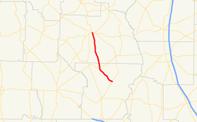
State Route 377 (SR 377) is a 20.0-mile-long (32.2 km) state highway that travels south-to-north through portions of Lee and Sumter counties in the southwestern part of the U.S. state of Georgia. The roadway was built in the late 1950s and was designated as SR 377 in the mid-1970s.
Route description
SR 377 begins at an intersection with SR 195 in rural Lee County. It heads northwest, and curves to the north-northwest, to an intersection with SR 118, east of Smithville. The route continues to the north-northwest, crossing into Sumter County along the way, and meets its northern terminus, two intersections with US 280/SR 27/SR 30/SR 49, on one-way pairs, in Americus. The highway roughly parallels US 19/SR 3 for nearly its entire length.[1]
SR 377 is not part of the National Highway System, a system of roadways important to the nation's economy, defense, and mobility.[2]
History
The road that would eventually become SR 377 was built between 1957 and 1960, but only between SR 195 and SR 118.[3][4] By 1966, the road was extended to Americus.[5][6] By 1976, the entire road was designated as SR 377.[7][8]
Major intersections
| County | Location | mi[1] | km | Destinations | Notes |
|---|---|---|---|---|---|
| Lee | | 0.0 | 0.0 | Southern terminus | |
| | 7.5 | 12.1 | |||
| Sumter | Americus | 19.9 | 32.0 | Eastbound lanes of US 280/SR 27/SR 30/SR 49 on one-way pairs | |
| 20.0 | 32.2 | Northern terminus; westbound lanes of US 280/SR 27/SR 30/SR 49 on one-way pairs | |||
| 1.000 mi = 1.609 km; 1.000 km = 0.621 mi | |||||
See also
-
.svg.png) Georgia (U.S. state) portal
Georgia (U.S. state) portal -
 U.S. Roads portal
References
- 1 2 3 Google (October 21, 2013). "Route of SR 377" (Map). Google Maps. Google. Retrieved October 21, 2013.
- ↑ "National Highway System: Georgia" (PDF). Federal Highway Administration. October 1, 2012. Retrieved October 21, 2013.
- ↑ Georgia State Highway System (PDF) (Map). Cartography by GSHD. Georgia State Highway Department. July 1, 1957. Retrieved August 14, 2015.
- ↑ Georgia State Highway System (PDF) (Map). Cartography by GSHD. Georgia State Highway Department. June 1, 1960. Retrieved August 14, 2015.
- ↑ Georgia State Highway System (PDF) (Map). Cartography by GSHD. Georgia State Highway Department. June 1, 1963. Retrieved August 14, 2015.
- ↑ Georgia State Highway System (PDF) (Map). Cartography by GSHD. Georgia State Highway Department. January 1, 1966. Retrieved August 14, 2015.
- ↑ Georgia State Highway System (PDF) (Map). Cartography by GSHD. Georgia State Highway Department. January 1, 1974. Retrieved August 14, 2015.
- ↑ Georgia State Highway System (PDF) (Map). Cartography by GSHD. Georgia State Highway Department. January 1, 1975. Retrieved August 14, 2015.