Georgia State Route 374
| ||||
|---|---|---|---|---|
 | ||||
| Route information | ||||
| Maintained by GDOT | ||||
| Length: | 7.9 mi[1] (12.7 km) | |||
| Existed: | 1972[2][3] – present | |||
| Major junctions | ||||
| South end: |
| |||
| North end: |
| |||
| Location | ||||
| Counties: | Seminole | |||
| Highway system | ||||
| ||||

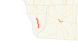
State Route 374 (SR 374) is a 7.9-mile-long (12.7 km) rural state highway located entirely in Seminole County in the southwestern part of the state of Georgia. The roadway was built in the early 1960s and was designated as SR 374 in 1972.
Route description
SR 374 begins at an intersection with SR 253 north of Lake Seminole and travels to the north and curves to the northwest. Then, it curves back to the north and again curves to the northwest until it reaches its northern terminus, an intersection with SR 39 approximately 6.8 miles (10.9 km) south of Donalsonville.[1]
SR 374 is not part of the National Highway System, a system of roadways important to the nation's economy, defense, and mobility.[4]
History
The roadway that would eventually become SR 374 was built between 1960 and 1963 on nearly exactly the same alignment as the current one.[5][6] In 1972, the roadway was extended southward to the northern shore of Lake Seminole and the entire roadway was designated as SR 374.[2][3] In 1997, the segment south of SR 253 was removed from the state highway system.[7][8]
Major intersections
The entire route is in Seminole County.
| Location | mi[1] | km | Destinations | Notes | |
|---|---|---|---|---|---|
| | 0.0 | 0.0 | Southern terminus | ||
| | 7.9 | 12.7 | Northern terminus | ||
| 1.000 mi = 1.609 km; 1.000 km = 0.621 mi | |||||
See also
-
.svg.png) Georgia (U.S. state) portal
Georgia (U.S. state) portal -
 U.S. Roads portal
References
- 1 2 3 Google (October 11, 2013). "Route of SR 374" (Map). Google Maps. Google. Retrieved October 11, 2013.
- 1 2 Georgia State Highway System (PDF) (Map). Cartography by GSHD. Georgia State Highway Department. January 1, 1972. Retrieved August 14, 2015.
- 1 2 Georgia State Highway System (PDF) (Map). Cartography by GSHD. Georgia State Highway Department. January 1, 1973. Retrieved August 14, 2015.
- ↑ "National Highway System: Georgia" (PDF). Federal Highway Administration. October 1, 2012. Retrieved October 11, 2013.
- ↑ Georgia State Highway System (PDF) (Map). Cartography by GSHD. Georgia State Highway Department. June 1, 1960. Retrieved August 14, 2015.
- ↑ Georgia State Highway System (PDF) (Map). Cartography by GSHD. Georgia State Highway Department. June 1, 1963. Retrieved August 14, 2015.
- ↑ Georgia State Highway System (PDF) (Map). Cartography by GSHD. Georgia State Highway Department. January 1, 1997. Retrieved August 14, 2015.
- ↑ Georgia State Highway System (PDF) (Map). Cartography by GSHD. Georgia State Highway Department. January 1, 1998. Retrieved August 14, 2015.