Georgia State Route 347
| ||||
|---|---|---|---|---|
 | ||||
| Route information | ||||
| Maintained by GDOT | ||||
| Length: | 12.3 mi[1] (19.8 km) | |||
| Existed: | 1963[2][3] – present | |||
| Major junctions | ||||
| West end: | Lake Lanier Islands north of Buford | |||
|
| ||||
| East end: |
| |||
| Location | ||||
| Counties: | Gwinnett, Hall | |||
| Highway system | ||||
| ||||

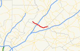
State Route 347 (SR 347) is a west-to-east state highway in the northeastern part of the U.S. state of Georgia. It travels from the Lake Lanier Islands north of Buford to a point on the northern edge of Braselton. Its routing is nearly completely within Hall County, but there is a tiny section at its eastern end that exists in Gwinnett County. The highway connects the Lake Lanier Islands with Buford and Braselton.
As the Atlanta metropolitan area has grown over the past few years, SR 347 has undergone strain from an influx of new subdivisions and housing developments, especially during morning and evening rush hours. SR 347 also serves as an important connector to the Lake Lanier Islands and the southeast portion of Lake Lanier from Interstate 985 (I-985).
Route description
SR 347 begins at the entrance to the Lake Lanier Islands beach and water park, along the southern part of Lake Lanier, in Hall County. It travels to the southeast on Holiday Road and enters the northeastern part of Buford. There it has an intersection with SR 13 (Atlanta Highway). It then continues to the southeast on Friendship Road to an interchange with I-985/US 23/SR 365 (Lanier Parkway). Then, the highway leaves Buford and curves to the east-northeast on Thompson Mill Road. It slips into Gwinnett County just before meeting its eastern terminus, an intersection with SR 211 (Old Winder Highway) on the northern edge of Braselton.[1]
SR 347 is not part of the National Highway System, a system of roadways important to the nation's economy, defense, and mobility.[4][5]
History
1960s to 1990s
SR 347 was built between 1960 and 1963, but it only traveled from the Lake Lanier Islands area to an intersection with US 23/SR 13. I-985 had not been built in this area, so US 23 still traveled along surface streets.[2][3] In 1968, it was extended to the under-construction freeway, which was then-proposed to be designated as SR 365. The roadway that would become the reminder of SR 347 was built at this time.[6][7] The road remained virtually unchanged for nearly 30 years. In 1997, SR 347 was extended further east along Friendship and Thompson Mill Roads to SR 211 more than doubling the length of the highway.[8][9]
Widening
Plans to widen Friendship Road (SR 347) began to appear in the late 1990s and early 2000s. In late 2012, the DOT began clearing and grading work to widening the road.[10] The road widening would be handled in three sections. Section one would extend from I-985/US 23/SR 365 to the Lake Lanier Islands Beach and Water Park. Section two would extend from Thompson Mill Road to SR 211. Section three would connect the first and second sections.
Renaming controversy
In early 2013, the Hall County Board of Commissioners met to discuss eliminating the name "Friendship Road" and replacing it with the name "Lanier Islands Parkway."[11] Château Élan Winery & Resort and the Town of Braselton both announced their displeasure with the potential name change.[12] The residents who live on Friendship Road were angered as well, as the change represented, to them, county government bowing to business pressure from Lake Lanier Islands. The residents are also upset about losing yet another connection with the area's past, as the Friendship Community stretches back over 100 years, yet so much is being lost due to the road construction.[13] Later, Hall County Board of Commissioners decided to keep it as Friendship Road within the Braselton Town Limits.
Major intersections
| County | Location | mi[1] | km | Destinations | Notes |
|---|---|---|---|---|---|
| Hall | Lake Lanier Islands | 0.0 | 0.0 | Lanier Islands Parkway, Holiday Road | Western terminus |
| Buford | 3.0 | 4.8 | |||
| 3.9 | 6.3 | I-985 exit 8. | |||
| Gwinnett | Braselton | 12.3 | 19.8 | Eastern terminus | |
| 1.000 mi = 1.609 km; 1.000 km = 0.621 mi | |||||
See also
-
.svg.png) Georgia (U.S. state) portal
Georgia (U.S. state) portal -
 U.S. Roads portal
References
- 1 2 3 Google (November 3, 2013). "Route of SR 347" (Map). Google Maps. Google. Retrieved November 3, 2013.
- 1 2 Georgia State Highway System (PDF) (Map). Cartography by GSHD. Georgia State Highway Department. June 1, 1960. Retrieved August 16, 2015.
- 1 2 Georgia State Highway System (PDF) (Map). Cartography by GSHD. Georgia State Highway Department. June 1, 1963. Retrieved August 16, 2015.
- ↑ National Highway System: Georgia (PDF) (Map). Cartography by FHWA. Federal Highway Administration. October 1, 2012. Retrieved November 3, 2013.
- ↑ National Highway System: Atlanta, GA (PDF) (Map). Cartography by FHWA. Federal Highway Administration. October 1, 2012. Retrieved November 3, 2013.
- ↑ Georgia State Highway System (PDF) (Map). Cartography by GSHD. Georgia State Highway Department. January 1, 1968. Retrieved August 16, 2015.
- ↑ Georgia State Highway System (PDF) (Map). Cartography by GSHD. Georgia State Highway Department. January 1, 1969. Retrieved August 16, 2015.
- ↑ Georgia State Highway System (PDF) (Map). Cartography by GSHD. Georgia State Highway Department. January 1, 1997. Retrieved August 16, 2015.
- ↑ Georgia State Highway System (PDF) (Map). Cartography by GSHD. Georgia State Highway Department. January 1, 1998. Retrieved August 16, 2015.
- ↑ "GDOT plans meeting on Friendship Rd. widening". AccessNorthGa.com. Jacobs Media. October 24, 2011. Retrieved November 3, 2013.
- ↑ Gill, Jeff (January 8, 2013). "Hall proposes changing name of Friendship Road". The Gainesville Times. Retrieved August 16, 2015.
- ↑ Akin, LeAnne (March 12, 2013). "Braselton keeps Friendship Road name in town". The Gainesville Times. Retrieved August 16, 2015.
- ↑ Gill, Jeff (March 9, 2013). "Friendship residents worried about heritage and future". The Gainesville Times. Retrieved August 16, 2015.