Georgia State Route 216
| ||||
|---|---|---|---|---|
 | ||||
| Route information | ||||
| Maintained by GDOT | ||||
| Length: | 40.4 mi[1] (65.0 km) | |||
| Major junctions | ||||
| Southeast end: |
| |||
|
| ||||
| North end: |
| |||
| Location | ||||
| Counties: | Baker, Early, Calhoun, Randolph | |||
| Highway system | ||||
| ||||

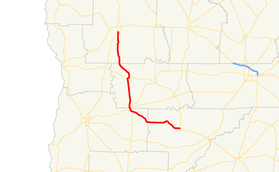
State Route 216 (SR 216) is a 40.4-mile-long (65.0 km) state highway located in the southwestern part of the U.S. state of Georgia. It runs southeast-to-north through portions of Baker, Early, Calhoun, and Randolph counties.
Route description
SR 216 begins at an intersection with SR 37 northwest of Newton, in central Baker County. It heads northwest, crossing into Early County, until it reaches Arlington. Almost immediately is an intersection with SR 45 (Joe Bryan Highway), which begins a concurrency with SR 216. Just after this is SR 62 (Blakely Road SW), which joins the concurrency. In downtown Arlington, the three highways enter Calhoun County and cross a Norfolk Southern Railway track. Then, SR 62 departs to the northeast on Pioneer Road. Two blocks later, SR 45 leaves the concurrency to the northeast on Morgan Road NE. SR 216 heads north to Edison, where it has a brief concurrency with SR 37 (Hartford Street). The highway heads north, curves to the northwest, and then curves back to the north, until it enters Randolph County. It continues heading north until it meets is northern terminus, an intersection with US 27/SR 1, just south of Cuthbert.[1]
Major intersections
| County | Location | mi[1] | km | Destinations | Notes |
|---|---|---|---|---|---|
| Baker | | 0.0 | 0.0 | Southeastern terminus | |
| Early | Arlington | 16.1 | 25.9 | Southern end of SR 45 concurrency | |
| 16.5 | 26.6 | Southern end of SR 62 concurrency | |||
| Calhoun | 17.2 | 27.7 | Northern end of SR 62 concurrency | ||
| 17.4 | 28.0 | Northern end of SR 45 concurrency | |||
| Edison | 25.6 | 41.2 | Southern end of SR 37 concurrency | ||
| 26.0 | 41.8 | Northern end of SR 37 concurrency | |||
| Randolph | | 40.4 | 65.0 | Northern terminus | |
1.000 mi = 1.609 km; 1.000 km = 0.621 mi
| |||||
See also
-
.svg.png) Georgia (U.S. state) portal
Georgia (U.S. state) portal -
 U.S. Roads portal
References
- 1 2 3 Google (June 18, 2013). "Route of SR 216" (Map). Google Maps. Google. Retrieved June 18, 2013.
External links
-
 Media related to Georgia State Route 216 at Wikimedia Commons
 - Georgia Roads (Routes 201 - 220)