Georgia State Route 19
| ||||
|---|---|---|---|---|
 | ||||
| Route information | ||||
| Maintained by GDOT | ||||
| Length: | 152.0 mi[1] (244.6 km) | |||
| Major junctions | ||||
| Southeast end: |
| |||
|
| ||||
| Northwest end: |
| |||
| Location | ||||
| Counties: | Bacon, Jeff Davis, Appling, Telfair, Wheeler, Laurens, Twiggs, Bibb, Monroe | |||
| Highway system | ||||
| ||||

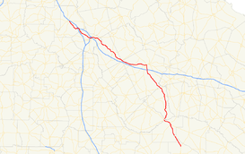
State Route 19 (SR 19) is a 152-mile-long (245 km) state highway that runs southeast-to-northwest through portions of Bacon, Jeff Davis, Appling, Telfair, Wheeler, Laurens, Twiggs, Bibb, and Monroe counties in the central part of the U.S. state of Georgia. The route travels from its southern terminus at US 1/US 23/SR 4 north of Alma to its northern terminus at US 41/SR 18 in Forsyth.
Route description
SR 19 begins at an intersection with US 1/SR 4 north of Alma. The route travels north, concurrent with US 23, which is also concurrent with US 1/SR 4 south of here. In Hazlehurst, US 341/SR 27 join the concurrency. In Lumber City, SR 19 departs to the north, crossing the Little Ocmulgee River, and begins to parallel the Oconee River north to Dublin. In Dublin, SR 19 travels concurrent with US 80. The two routes travel west to Macon. In Macon, SR 19 leaves US 80 and travels concurrent with US 23 again, and later, US 41. The routes travel north to Forsyth, where SR 18 runs concurrent with US 41, and SR 19 meets its northern terminus.
In 1998, the Georgia state legislature passed a resolution designating a portion of SR 19 in Macon as "Duane Allman Boulevard" and a bridge thereon as "Raymond Berry Oakley III Bridge" in honor and remembrance of late founding members of The Allman Brothers Band.[2]
The following sections of SR 19, that are concurrent with U.S. Highways, are the only segments that are included as part of the National Highway System, a system of roadways important to the nation's economy, defense, and mobility
- The section concurrent with US 23/US 341/SR 27 from Hazlehurst to Lumber City[3]
- The section concurrent with US 80/SR 26 from Dublin to the intersection with US 441 Bypass/SR 117 west of the city[4]
- Macon:[5]
- The section concurrent with US 80 from the intersection with SR 57 east of Macon to the intersection with US 23/US 129 Alternate/SR 87 northwest of the Macon Downtown Airport
- The section concurrent with US 23/US 80/US 129 Alternate/SR 87 from northwest of the Macon Downtown Airport to just northeast of Coliseum Medical Center, where US 80/SR 87 split off
- The section concurrent with US 23/US 129 Alternate from just northeast of Coliseum Medical Center to just northwest of the hospital, where US 129 Alternate splits off
- The section concurrent with US 23 from just northwest of Coliseum Medical Center to just before crossing under I-16, where US 129/SR 11/SR 49 join the concurrency
- The section concurrent with US 23/US 129/SR 11/SR 49 from northwest of River Edge Behavioral Health Center to Riverside Drive, where US 23, US 129, and SR 11 split off
- The section concurrent with SR 49 from Riverside Drive to Walnut Street, where SR 49 splits off and US 41 Business joins
- The section concurrent with US 41 Business from Walnut Street to Pio Nono Avenue, where US 41 Business ends and US 41 joins
- The section concurrent with US 41 from Pio Nono Avenue to Old Forsyth Road[6][7]
Major intersections
| County | Location | mi | km | Destinations | Notes | |||
|---|---|---|---|---|---|---|---|---|
| Bacon | | 0.0 | 0.0 | Southern terminus, southern end of US 23 concurrency | ||||
| Appling |
No major junctions | |||||||
| Jeff Davis |
No major junctions | |||||||
| Appling |
No major junctions | |||||||
| Jeff Davis | | Southern terminus of SR 135 Conn. | ||||||
| Hazlehurst | Southern end of US 341/SR 27 concurrency | |||||||
| One-way pair | ||||||||
| Telfair | Lumber City | Northern end of US 23/US 341/SR 27 concurrency | ||||||
| Wheeler | Jordan | Eastern terminus of SR 126 | ||||||
| Glenwood | ||||||||
| | ||||||||
| Laurens | | I-16 exit 54; Diamond interchange. | ||||||
| Dublin | Southern end of US 441 concurrency | |||||||
| Eastern end of US 80/SR 26 concurrency, northern end of US 441 concurrency | ||||||||
| | ||||||||
| Dudley | ||||||||
| | Western end of SR 26 concurrency | |||||||
| Montrose | Eastern terminus of SR 278 | |||||||
| Wilkinson | Allentown | |||||||
| Twiggs | | Eastern terminus of SR 358 | ||||||
| Jeffersonville | Eastern end of SR 96 concurrency | |||||||
| Eastern terminus of SR 18, western end of SR 96 concurrency | ||||||||
| Bibb | | Western terminus of SR 57 | ||||||
| | Northern terminus of SR 87 Conn. | |||||||
| | Eastern end of US 23/US 129 Alt./SR 87 concurrency | |||||||
| Macon | Western end of US 80/SR 87 concurrency | |||||||
| Western end of US 129 Alt. concurrency | ||||||||
| Northern end of US 129/SR 11/SR 49 concurrency | ||||||||
| Southern end of US 129/SR 11 concurrency | ||||||||
| Eastern end of US 41 Bus. concurrency, southern end of SR 49 concurrency | ||||||||
| I-75 exit 164; Diamond interchange. | ||||||||
| Northern terminus of US 41 Bus., southern end of US 41 concurrency | ||||||||
| | ||||||||
| Monroe | | I-475 exit 15; Folded diamond interchange. | ||||||
| Forsyth | Northern terminus, northern end of US 41 concurrency | |||||||
1.000 mi = 1.609 km; 1.000 km = 0.621 mi
| ||||||||
Bannered route
| |
|---|---|
| Location: | Hazlehurst |
| Length: | 0.2 mi[8] (0.3 km) |
State Route 19 Connector (SR 19 Connector) is a 0.2-mile-long (0.32 km) connector route that exists entirely within the city limits of Hazlehust in the north central part of Jeff Davis County, and is known as East Coffee Street for its entire length.
It begins at an intersection with US 221/SR 135 (South Tallahassee Street) in the central part of Hazlehurst. It heads northeast for two blocks and has a slight curve to the east. At that point, it meets its northern terminus, an intersection with US 23/US 341/SR 19/SR 27.[8]
SR 19 Connector is not part of the National Highway System, a system of roadways important to the nation's economy, defense, and mobility.[6]
The entire route is in Hazlehurst, Jeff Davis County.
| mi[1] | km | Destinations | Notes | ||
|---|---|---|---|---|---|
| 0.0 | 0.0 | Southern terminus | |||
| 0.2 | 0.32 | Northern terminus | |||
| 1.000 mi = 1.609 km; 1.000 km = 0.621 mi | |||||
See also
-
.svg.png) Georgia (U.S. state) portal
Georgia (U.S. state) portal -
 U.S. Roads portal
References
- 1 2 Google (August 23, 2013). "Route of SR 19" (Map). Google Maps. Google. Retrieved August 23, 2013.
- ↑ Senator Brown,; Georgia State Senate (March 12, 1998). "SR 653 Duane Allman and Berry Oakley III Bridge - designate". State of Georgia. Retrieved 2009-06-23.
- ↑ Google (December 25, 2013). "Route of SR 19's National Highway System routing (Hazlehurst to Lumber City)" (Map). Google Maps. Google. Retrieved December 25, 2013.
- ↑ Google (December 25, 2013). "Route of SR 19's National Highway System routing (Dublin area)" (Map). Google Maps. Google. Retrieved December 25, 2013.
- ↑ Google (December 25, 2013). "Route of SR 19's National Highway System routing (Macon area)" (Map). Google Maps. Google. Retrieved December 25, 2013.
- 1 2 "National Highway System: Georgia" (PDF). United States Department of Transportation. November 15, 2013. Retrieved December 25, 2013.
- ↑ "National Highway System: Macon, GA" (PDF). United States Department of Transportation. October 1, 2012. Retrieved August 24, 2013.
- 1 2 Google (August 24, 2013). "Route of SR 19 Connector" (Map). Google Maps. Google. Retrieved August 24, 2013.