Georgetown, Connecticut
| Georgetown, Connecticut | |
|---|---|
| Census-designated place | |
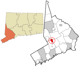 Location in Fairfield County and the state of Connecticut. | |
| Coordinates: 41°15′24″N 73°26′1″W / 41.25667°N 73.43361°W | |
| Country | United States |
| State | Connecticut |
| County | Fairfield County |
| Town | Redding, Weston, Wilton, Ridgefield |
| Area | |
| • Total | 2.9 sq mi (7.4 km2) |
| • Land | 2.8 sq mi (7.3 km2) |
| • Water | 0.0 sq mi (0.0 km2) |
| Elevation | 354 ft (108 m) |
| Population (2010) | |
| • Total | 1,805 |
| • Density | 620/sq mi (240/km2) |
| Time zone | Eastern (EST) (UTC-5) |
| • Summer (DST) | EDT (UTC-4) |
| ZIP code | 06829 |
| Area code(s) | 203 |
| FIPS code | 09-30540 |
| GNIS feature ID | 0207283 |
Georgetown is a village and census-designated place in Fairfield County, Connecticut, United States. It is located in the area where the towns of Wilton, Redding, Ridgefield, and Weston meet.
The village and its surrounding area are also defined as the Georgetown census-designated place (CDP). As of the 2010 census, the population of the CDP was 1,805.[1]
Georgetown is located at the southwest corner of the town of Redding, the northwest corner of the town of Weston, the southeast corner of the town of Ridgefield, and the northeast corner of the town of Wilton. Georgetown residents officially live in and pay local taxes to one of these four towns, but typically identify themselves as living in Georgetown. Georgetown has its own fire district, which also serves the surrounding rural areas not traditionally included in Georgetown, and its own ZIP code (06829).
Historic district
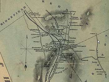
On April 9, 1987, the central portion of the village was listed on the U.S. National Register of Historic Places as the Georgetown Historic District. A map shows its approximate location within Georgetown.[2] The historic district is an area of 90 acres (360,000 m2) that includes the Gilbert and Bennett manufacturing plant, institutional housing built for the plant workers, and other private homes. The district includes portions of Georgetown in the towns of Redding and Wilton.[3]
Geography
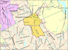
According to the United States Census Bureau, the CDP has a total area of 2.85 square miles (7.4 km2), of which 2.84 square miles (7.4 km2) is land and 0.02 square miles (0.052 km2), or 0.70%, is water. Of the total area of the CDP, 2.36 square miles (6.1 km2) are in Wilton, 0.33 square miles (0.85 km2) are in Redding, and 0.16 square miles (0.41 km2) are in Weston.
Demographics
As of the census[4] of 2000, there were 1,650 people, 572 households, and 455 families residing in the CDP. The population density was 581.8 people per square mile (224.3/km2). There were 597 housing units at an average density of 210.5 per square mile (81.2/km2). The racial makeup of the CDP was 90.62% White, 1.33% African American, 0.24% Native American, 3.39% Asian, 0.48% from other races, and 0.55% from two or more races. Hispanic or Latino of any race were 3.39% of the population.
There were 572 households out of which 44.9% had children under the age of 18 living with them, 71.0% were married couples living together, 4.7% had a female householder with no husband present, and 20.3% were non-families. 16.3% of all households were made up of individuals and 5.9% had someone living alone who was 65 years of age or older. The average household size was 2.87 and the average family size was 3.27.
In the CDP the population was spread out with 30.4% under the age of 18, 3.3% from 18 to 24, 29.9% from 25 to 44, 27.7% from 45 to 64, and 8.7% who were 65 years of age or older. The median age was 38 years. For every 100 females there were 100.0 males. For every 100 females age 18 and over, there were 99.1 males.
The median income for a household in the CDP was $103,424, and the median income for a family was $110,081. Males had a median income of $81,538 versus $59,531 for females. The per capita income for the CDP was $55,029. About 2.0% of families and 4.7% of the population were below the poverty line, including 3.5% of those under age 18 and 4.6% of those age 65 or over.
Movies filmed in Georgetown
- Reckless (1995)
- Other People's Money (1991)
- Rachel, Rachel (1968)[5]
Pictures
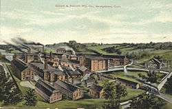 Gilbert & Bennett factory, 1909
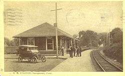 Georgetown train station, sometime before 1919
See also
- Branchville (Ridgefield), a section of the town of Ridgefield sometimes considered part of Georgetown.
References
- ↑ "Race, Hispanic or Latino, Age, and Housing Occupancy: 2010 Census Redistricting Data (Public Law 94-171) Summary File (QT-PL), Georgetown CDP, Connecticut". U.S. Census Bureau, American FactFinder 2. Retrieved August 11, 2011.
- ↑ Google-based map showing approximate boundaries of Georgetown CDP and of Georgetown Historic District within it
- ↑ Jan Cunningham and John Herzan (June 25, 1986). "National Register of Historic Places Inventory-Nomination: Georgetown Historic District" (PDF). National Park Service. and Accompanying 25 photos, from 1986
- ↑ "American FactFinder". United States Census Bureau. Retrieved 2008-01-31.
- ↑ Internet Movie DataBase page for Georgetown, Connecticut, accessed on July 3, 2006
External links
| Wikimedia Commons has media related to Georgetown, Connecticut. |
- History of Georgetown, Connecticut, from the History of Redding website
- Lisa Prevost, "A Mill Town Writes Its Next Chapter", part of the "Living In" section in the Real Estate section of The New York Times, January 30, 2005 and August 29, 2006
- Photographs of Historic Buildings, Town of Wilton website
Municipalities and communities of Fairfield County, Connecticut, United States | ||
|---|---|---|
| Cities | 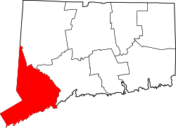 | |
| Towns | ||
| Borough | ||
| CDPs | ||
| Other communities | ||
Coordinates: 41°15′20″N 73°26′05″W / 41.25556°N 73.43472°W