Geology of the Pacific Ocean
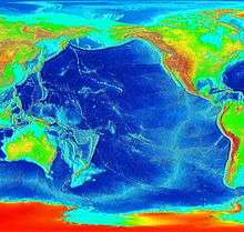

The Pacific Ocean evolved in the Mesozoic from the Panthalassic Ocean, which had formed when Rodinia rifted apart around 750 Ma. The first ocean floor which is part of the current Pacific Plate began 160 Ma to the west of the central Pacific and subsequently developed into the largest oceanic plate on Earth.[1]
The tectonic plates continue to move today. The slowest spreading ridge is the Gakkel Ridge on the Arctic Ocean floor which spreads at less that 2.5 cm/yr while the fastest, the East Pacific Rise near Easter Island, has a spreading rate of over 15 cm/yr.
History
The Pacific Ocean developed from the Panthalassa, a vast global ocean, following the breakup of the supercontinent Pangaea in the Mesozoic Era, gradually forming Gondwana and Laurasia, which in turn divided.[2][3] There is no firm date for when the changeover occurred, as the replacement of the sea bed is a continuous process, though reconstruction maps often change the name from Panthalassic to Pacific around the time the Atlantic Ocean began to open.[4] The Panthalassic Ocean first opened around 750 million years ago at the breakup of Rodinia,[4] but the oldest Pacific Ocean floor is only around 180 Ma old. Any older Pacific floor crust has been subducted.[5]
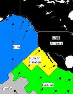
During the Jurassic period, four tectonic plates developed in the Pacific Basin: the Kula and the Farallon in the north, the large Pacific Plate in the centre and south and the Phoenix Plate in the far south. The Kula Plate was subducted under the eastern and south-eastern Asian landmass. The northern part of the Farallon was subducted under North America while its southern section, together with the Phoenix Plate, was subducted under South America and the Antarctic. During the late Tertiary period, the Farallon plate broke up, leaving the Juan de Fuca Plate in the north, the Cocos Plate off today's Central America, and the Nazca and Phoenix Plates in the southern Pacific.[6][7]
Charles Darwin had proposed a theory of the slow subsidence of the ocean floor based on his studies of Pacific oceanic islands, seamounts (underwater volcanoes) and guyots (flat-topped seamounts). His observations have been verified and expanded in the development of plate tectonic theory.[8]
The tectonic plates continue to move today. The slowest ridge spreading rate is across the Gakkel Ridge in the Arctic Ocean which separates at less than 2.5 cm/yr while the fastest, across the East Pacific Rise near Easter Island, has a spreading rate of over 15 cm/yr.[9] The Pacific Plate moves generally towards the northwest at between 7 and 11 cm/yr while the Juan De Fuca Plate has an east-northeasterly movement of some 4 cm/yr.[10]
Geological origins of the Pacific islands
The theory of plate tectonics, which is supported by seismology, volcanology, gravimetry, and paleomagnetism (remanent magnetism), explains the origin of the physical features of the Pacific.[8] The islands of the Pacific have developed in a number of ways. Some have originated as chains of volcanic islands on the tectonic plates either as a result of mantle plumes or by fracture propagation. Atolls have developed in tropical waters when, after volcanos sink, coral growth results in reefs as evidenced by the Cook Islands. Coral reefs can develop into islands over a submerged extinct volcano following uplift as in Makatea and Rennell Island in the Solomon Archipelago which have steep coral cliffs over 100 metres high.[1]
The collision of two plates, resulting in subduction, have contributed to the emergence of the western Pacific arcs of volcanic islands. A new crust has emerged as the East Pacific Rise. In the northeastern Pacific margin there is a lateral shift, through the San Andreas Fault system, of the North American Plate and the Pacific Plate.[8]
Plate movements have also caused fragments of continental crust to be rotated away from landmasses so as to form islands. Zealandia which broke off from Gondwana 70 million years ago with the spreading of the Tasman Sea, has since resulted in island protrusions such as New Zealand and New Caledonia. Related causes of island formation include obduction and subduction at convergent plate boundaries. Malaita and Ulawa in the Solomon Islands are the result of obduction while the effects of subduction can be seen in the formation of volcanic island arcs such as the Aleutian Arc off Alaska and the Kermadec-Tonga Subduction Zone north of New Zealand.[1]
As a result of the collision of the Nazca Plate and the South American Plate, the Andes Mountains emerged in western South America, close to the Peru–Chile Trench.[8] Many large fracture zones aligned in an east-west direction, occur in the floor of the northeastern Pacific.[8]
Andesite line
The Pacific is a broad ocean basin (unlike the narrow Atlantic Ocean) and extends over a width of 10,000 miles (16,000 km) between New Guinea and Peru.[11] The andesite line, a zone of intense volcanic and seismic activity, is a major regional distinction in the Pacific. The petrologic boundary separates the deeper mafic igneous rock of the Central Pacific Basin from the partially submerged continental areas of felsic igneous rock on its margins.[12] The andesite line follows the western edge of the islands off California and passes south of the Aleutian arc, along the eastern edge of the Kamchatka Peninsula, the Kuril Islands, Japan, the Mariana Islands, the Solomon Islands, and New Zealand's North Island.[13][14]
The dissimilarity continues northeastward along the western edge of the Andes Cordillera along South America to Mexico, returning then to the islands off California. Indonesia, the Philippines, Japan, New Guinea, and New Zealand lie outside the andesite line.
Outside of the andesite line, volcanism is explosive; the Pacific Ring of Fire is the world's foremost belt of explosive volcanism. The Ring of Fire is named after the several hundred active volcanoes that sit above the various subduction zones. In 2009, the deepest undersea eruption ever recorded occurred at the West Mata submarine volcano, a mile beneath the ocean, close to the Tonga-Kermadec Trench, within the Ring of Fire;[15] it was filmed by the US Jason robotic submersible which descended over 1,100 metres (3,600 ft).[16] The Pacific Ocean is the only ocean which is almost totally bounded by subduction zones. Only the Antarctic and Australian coasts have no nearby subduction zones.
Earthquakes
In March and April 2008, a series or swarm of moderate earthquakes occurred both near and within the Blanco Fracture Zone. The swarm began on 30 March when over 600 measurable tremors began occurring north of the zone within the Juan de Fuca Plate.[17] A decade earlier, in January 1998, another swarm was detected at Axial Seamount in the Juan de Fuca Ridge.[18] At the time of its occurrence, scientists were not aware that the series of faults in this plate even existed.[19] In a remote region of the central Pacific Ocean, at the southeastern section of the Gilbert Islands, a major swarm of intraplate earthquakes occurred between December 1981 and March 1983, with no prior seismicity having been reported in this region previously.[20] Another swarm was detected on the Queen Charlotte Islands fracture zone in August–September 1967.[21]
Features
Seamount chains and hotspots
The Pacific Ocean contains several long seamount chains, formed by hotspot volcanism. These include the Hawaiian–Emperor seamount chain and the Louisville seamount chain.
Arcs and belts
Faults and fracture zones
Underwater ridges and plateaus
- Carnegie Ridge
- Chile Rise
- Darwin Rise
- East Pacific Rise
- East Tasman Plateau
- Explorer Ridge
- Galapagos Rise
- Gorda Ridge
- Juan de Fuca Ridge
- Juan Fernández Ridge
- Kula-Farallon Ridge
- Lord Howe Rise
- Nazca Ridge
- Norfolk Ridge
- Pacific-Antarctic Ridge
- Pacific-Farallon Ridge
- Pacific-Kula Ridge
- Phoenix Ridge
- Tehuantepec Ridge
Trenches and troughs
Plates
- Amurian Plate
- Antarctic Plate
- Balmoral Reef Plate
- Banda Sea Plate
- Bird's Head Plate
- Caroline Plate
- Cocos Plate
- Conway Reef Plate
- Easter Plate
- Eurasian Plate
- Futuna Plate
- Galapagos Microplate
- Gorda Plate
- Halmahera Plate
- Indo-Australian Plate
- Juan de Fuca Plate
- Juan Fernández Plate
- Kermadec Plate
- Kula Plate
- Manus Plate
- Maoke Plate
- Mariana Plate
- Molucca Sea Plate
- Nazca Plate
- New Hebrides Plate
- Niuafo'ou Plate
- North American Plate
- North Bismarck Plate
- North Galapagos Microplate
- Okhotsk Plate
- Okinawa Plate
- Pacific Plate
- Philippine Sea Plate
- Rivera Plate
- Sangihe Plate
- Solomon Sea Plate
- South Bismarck Plate
- Sunda Plate
- Timor Plate
- Tonga Plate
- Woodlark Plate
- Yangtze Plate
Volcanoes
- Alcedo Volcano
- Alofi Island
- Ball's Pyramid
- Bartolomé Island
- Clarion Island
- Daphne Island
- Eastern Gemini Seamount
- Futuna (Wallis and Futuna)
- Galápagos Islands
- Genovesa Island
- Hallasan
- Isabela Island (Galápagos)
- Isla Salas y Gómez
- Lord Howe Island
- Maquinna
- Marchena Island
- Matthew and Hunter Islands
- Mount Lidgbird
- Norfolk Island
- Nunivak Island
- Phillip Island (Norfolk Island)
- Pinta Island
- Poike
- Rábida Island
- Revillagigedo Islands
- Rocas Alijos
- San Benedicto Island
- Santiago Island (Galápagos)
- Sierra Negra (Galápagos)
- Socorro Island
- Volcán Wolf
References
- 1 2 3 Neall, Vincent E.; Trewick, Steven A. (27 October 2008). "The age and origin of the Pacific islands: a geological overview". Phil. Trans. R. Soc. B. 363 (1508): 3293–3308. doi:10.1098/rstb.2008.0119. PMC 2607379
 . PMID 18768382. Retrieved 23 June 2013.
 - ↑ Zhai, M. G. (2007). Mesozoic Sub-Continental Lithospheric: Thinning Under Eastern Asia. Geological Society. pp. 123–. ISBN 978-1-86239-225-0.
- ↑ Carmen Arias, "Palaeoceanography and biogeography in the Early Jurassic Panthalassa and Tethys Oceans", Universidad Complutense de Madrid. Retrieved 25 June 201.
- 1 2 "GEOL 102 The Proterozoic Eon II: Rodinia and Pannotia". Geol.umd.edu. 5 January 2010. Retrieved 23 June 2013.
- ↑ Mussett, Alan E.; Khan, M. Aftab (2000). Looking into the Earth: An Introduction to Geological Geophysics. Cambridge University Press. p. 332. ISBN 978-0-521-78574-7.
- ↑ Glasby, G.P. (1989). Antarctic Sector of the Pacific. Elsevier. pp. 131–. ISBN 978-0-08-087089-2.
- ↑ Foulger, Gillian R.; Jurdy, Donna M. (2007). Plates, Plumes, and Planetary Processes. Geological Society of America. pp. 479–. ISBN 978-0-8137-2430-0.
- 1 2 3 4 5 "Pacific Ocean". Geology. Encyclopædia Britannica. Retrieved 26 June 2013.
- ↑ "Understanding plate motions", USGS. Retrieved 26 June 2013.
- ↑ "Plate Tectonics", Pacific Northwest Seismic Network. Retrieved 26 June 2013.
- ↑ "The Geological History of the Pacific Ocean". Nature.com. Retrieved 26 June 2013.
- ↑ Trent, D. D.; Hazlett, Richard; Bierman, Paul (2010). Geology and the Environment. Cengage Learning. p. 133. ISBN 978-0-538-73755-5.
- ↑ Mueller-Dombois, Dieter (1998). Vegetation of the Tropical Pacific Islands. Springer. p. 13. ISBN 978-0-387-98313-4.
- ↑ Lal, Brij Vilash; Fortune, Kate (January 2000). The Pacific Islands: An Encyclopedia. University of Hawaii Press. p. 4. ISBN 978-0-8248-2265-1.
- ↑ Sandell, Clayton (17 December 2009). "Deepest Undersea Volcanic Eruption Ever Seen". ABC News. Retrieved 26 June 2013.
- ↑ Amos, Jonathan (18 December 2009). "Deepest volcano caught on Pacific Ocean video – Amazing video has been obtained in the Pacific Ocean of the deepest undersea eruption ever recorded". BBC. Retrieved 26 June 2013.
- ↑ "2008 Oregon Offshore Earthquakes". NOAA. Retrieved 23 June 2013.
- ↑ Dziak, Robert P.; Fox, Christopher G. (1 December 1999). "The January 1998 Earthquake swarm at Axial Volcano, Juan de Fuca Ridge: Hydroacoustic evidence of seafloor volcanic activity". Geophysical Research Letters. 26 (23): 3429–3432. Bibcode:1999GeoRL..26.3429D. doi:10.1029/1999gl002332.
- ↑ Floyd, Mark (26 October 2009). "OSU researchers find cause of 2008 offshore earthquake swarms". Corvallis Gazette Times. Retrieved 26 June 2013.
- ↑ Lay, Thorne; Okal, Emile (1983). "The Gilbert Islands (Republic of Kiribati) earthquake swarm of 1981—1983" (PDF). Physics of the Earth and Planetary Interiors. 33: 284–303. Bibcode:1983PEPI...33..284L. doi:10.1016/0031-9201(83)90046-8.
- ↑ Wetmiller, Robert J. (December 1971). "An earthquake swarm on the Queen Charlotte Islands Fracture Zone". Bulletin of the Seismological Society of America. 61 (6): 1489–1505.
External links
| Wikimedia Commons has media related to Geology of the Pacific Ocean. |