Geology of Nepal
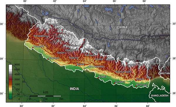
The Himalaya is the highest, youngest and a very highly active mountain range.[1] Himalaya is a type locality for the study of on-going continent-continent collision tectonics.[1] The Himalayan arc extends about 2400 km from Nanga Parbat (8,138 m) by the Indus River in northern Pakistan eastward to Namche Barwa (7,756 m) by the gorge of the Tsangpo-Brahmaputra in eastern Tibet (Le Fort 1996). About 800 km of this extent is in Nepal; the remainder includes Bhutan and parts of Pakistan, India, and China.
Since 55 Ma the Himalayan orogeny beginning with the collision of Indian subcontinent and Eurasia at the Paleocene/Eocene epoch (Rowley 1996), has thickened the Indian crust to its present thickness of 70 km (Le Fort 1975). The northwest tip of India after colliding with Asia seems to have met along the full length of the suture by about 40 Ma (Dewey et al. 1988).
Immediately prior to the onset of the Indo-Asian collision, the northern boundary of the Indian shield was likely a thinned continental margin on which Proterozoic clastic sediments and the Cambrian ±Eocene Tethyan shelf sequence were deposited (Le Fort 1996).
Morpho-tectonic division of Nepal Himalaya
Heim & Gansser 1939, and Gansser 1964 divided the rocks of the Himalaya into four tectonostratigraphic zones that are characterised by distinctive stratigraphy and physiography. From south to north,it can be divided into five latitudinal morpho-tectonic zones and these are :
1.The Gangatic Plain (Terai)
2. The Sub Himalayan,
3 Lesser Himalayan,
4.Greater Himalayan, and
5.Tibetan Himalayan zones.
Gangetic plain
The gangetic plain is also called the Terai which is a rich, fertile and ancient land in the southern parts of Nepal. It represents Holocene/Recent sedimentation belt where fluvial sedimentation is still in progress. This plain is less than 200 m above sea level and has thick (about 1500 m) alluvial deposit. The alluvial deposits mainly consists of boulders, gravel, sand,silt and clay. It is a foreland basin which consists of the sediments brought down from the northern part of Nepal. It is the Nepalese extension of the Indo-Gangetic Plains, which covers most of northern and eastern India, the most populous parts of Pakistan, and virtually all of Bangladesh. The Plains get their names from the rivers Ganges and Indus.
The vast alluvial plains of the Indo-Gangetic Basin evolved as a foreland basin in the southern part of the rising Himalaya, before breaking up along a series of steep faults known as the Himalayan Frontal Fault (Nakata 1989) or the Main Frontal Thrust (Gansser 1981). It comprises several sub-basins and all of them are quite shallow towards the south, but rather deep in the northern sections.
Sub-Himalaya (Siwaliks)
The Sub-Himalayan Sequence borders the Indo-Gangetic Floodplain along the Himalayan Frontal Fault and is dominated by thick Late Tertiary mollassic deposits known as the Siwaliks that resulted from the accumulating fluvial deposits on the southern front of the evolving Himalaya. In Nepal, it extends throughout the country from east to west in the southern part. It is delineated by the Himalayan Frontal Thrust (HFT) and Main Boundary Thrust (MBT) in south and north respectively. The youngest sediments on the top are the conglomerates, and the sandstones and mudstones are dominant in the lower portions. The upward coarsening sequence of the sediments obviously exhibit the time-history in the evolution and growth of the Himalaya during the early Tertiary time (Gansser 1964).
The Sub Himalayan zone is the 10 to 25 km wide belt of Neogene Siwaliks (or Churia) group rocks forming the topographic front of the Himalaya. It rises from the fluvial plains of the active foreland basin, and this front generally mapped as the trace of the Main Frontal Thrust (MFT). The Siwaliks Group consists of upward-coarsening successions of fluvial mudstone, siltstone, sandstone, and conglomerate.
The Siwaliks Group in Nepal is composed of three units that are known as lower, middle and upper members. These units can be correlated with the Sub Himalaya of Pakistan and of northern India (Burbank, Beck & Mulder 1996). Palaeocurrent and petrographic data from the sandstone and conglomerate indicate that these rocks were derived from the fold-thrust belt, and deposited within the flexural foredeep of the Himalayan foreland basin (Tokuoka et al. 1986; DeCelles et al. 1998).
Lesser Himalaya
The Lesser Himalayas lies in between the Sub-Himalayas and Higher Himalayas separated by the Main Boundary Thrust (MBT) and the Main Central Thrust (MCT) respectively. The total width ranges from 60–80 km. The Lesser Himalayas is made up mostly of the unfossiliferous sedimentary and metasedimentary rocks; such as shale, sandstone, conglomerate, slate, phyllite, schist, quartzite, limestone and dolomite. The rocks range in age from Precambrian to Miocene. The geology is complicated due to folding, faulting and thrusting and are largely unfossiliferous. Tectonically, the entire Lesser Himalayas consists of two sequences of rocks: allochthonous, and autochthonous-paraautochthonous units; with various nappes, klippes and tectonic windows.
The northernmost boundary of the Siwaliks Group is marked by the Main Boundary Thrust (MBT), over which the low-grade metasedimentary rocks of the Lesser Himalaya overlie. The Lesser Himalaya, also called the Lower Himalaya, or the Midlands, is a thick (about 7 km) section of para-autochthonous crystalline rocks made up of low- to medium grade rocks. These lower Proterozoic clastic rocks (Parrish & Hodges 1996) are subdivided into two groups. Argillo-arenaceous rocks dominate the lower half of the succession, whereas the upper half consists of both carbonate and siliciclastic rocks (Hagen (1969); Le Fort 1975; Stöcklin 1980).
The Lesser Himalaya thrust over the Siwaliks along the MBT to the south, and is overlained by the allochthonous thrust sheets of Kathmandu and HHC along the MCT. The Lesser Himalaya is folded into a vast post-metamorphic anticlinal structure known as the Kunchha-Gorkha anticlinorium (Pêcher 1977). The southern flank of the anticlinorium is weakly metamorphosed, whereas the northern flank is highly metamorphosed.
Main Central Thrust Zone
The Main Central thrust (MCT) is the single largest structure within the Indian plate that has accommodated Indian-Asian convergence. It extends for nearly 2500 km along strike and has been the site of at least 140 and perhaps more than 600 km of displacement (Schelling & Arita 1991; Srivastava & Mitra 1994). Heim & Gansser 1938 defined the MCT in Kumaon based on the difference in metamorphic grade between low to medium-grade rocks of the Lesser Himalaya and higher-grade rocks of the Greater Himalaya. However, the fault originally defined by Heim & Gansser 1938 is not the MCT, but a fault within Lesser Himalaya rocks (Valdiya 1980; Ahmad et al. 2000). This misidentification symbolizes the challenge that workers have faced in locating the MCT. The metamorphic grade within the Lesser Himalaya increases towards the MCT and at higher structural levels.
In central Nepal, the metamorphic grade increases from low (chlorite + biotite) to medium (biotite + garnet + kyanite + staurolite) towards the MCT over a north-south distance. The highest-grade rocks (kyanite and sillimanite gneisses) are found within the MCT shear zone, i.e. upper Lesser Himalaya. Arita (1983) places two thrusts (MCT I and MCT II) on each side of the MCT shear zone.
Higher Himalaya
This zone extends from the MCT to Tibetan-Tethys Zone and runs throughout the country. This zone consists of almost 10 km thick succession of the crystalline rocks, commonly called the Himal Group. This sequence can be divided into four main units, as Kyanite-Sillimanite gneiss, pyroxenic marble and gneiss, banded gneiss, and augen gneiss in the ascending order (Bordet, Colchen & LeFort 1972).
The Higher Himalayan sequence has been variously named. French workers used the term Dalle du Tibet (Tibetan Slab) for this unit (Le Fort 1975; Bordet, Colchen & LeFort 1972). Hagen (1969) called them Khumbu Nappes, and Lumbasumba Nappes. Arita (1983) calls it the Himalayan Gneiss Group, and it lies above the MCT II, or the upper MCT.
The High Himalayan Crystalline units (HHC) (Bollinger et al. 2004) are mainly composed of kyanite- to sillimanite-grade gneisses intruded by High Himalayan leucogranites at structurally higher levels (Upreti 1999). Throughout much of the range, the unit is divided into three formations (Pêcher & Le Fort 1986). In central Nepal (Guillot 1999), the upper Formation III consists of augen orthogneisses, whereas the Middle Formation II are calcsilicate gneisses and marbles, and the basal Formation I are kyanite- and sillimanite bearing metapelites, gneisses, and metagreywacke with abundant quartzite.
The gneiss of Higher Himalayan zone (HHZ) is a thick continuous sequence of about 5 to 15 km (Guillot 1999). The northern part is marked by North Himalayan Normal fault (NHNF), which is also known as the South Tibetan Detachment system (STDS). At its base, it is bounded by the MCT. The protolith of the HHC is interpreted to be Late Proterozoic clastic sedimentary rocks deposited on the northern Indian margin (Parrish & Hodges 1996).
Tibetan-Tethys
The Tibetan-Tethys Himalayas generally begins from the top of the Higher Himalayan Zone and extends to the north in Tibet. In Nepal these fossiliferous rocks are well developed in Thak Khola (Mustang), Manang and Dolpa area. This zone is about 40 km wide and composed of fossiliferous sedimentary rocks such as shale, sandstone and limestone etc.
The area north of the Annapurna and Manaslu ranges in central Nepal consists of metasediments that overlie the Higher Himalayan zone along the South Tibetan Detachment system. It has undergone very little metamorphism except at its base where it is close to the Higher Himalayan crystalline rocks. The thickness is currently presumed to be 7,400 m (Fuchs, Widder & Tuladhar 1988). The rocks of the Tibetan Tethys Series (TSS) consist of a thick and nearly continuous lower Paleozoic to lower Tertiary marine sedimentary succession. The rocks are considered to be deposited in a part of the Indian passive continental margin (Liu & Einsele 1994).
See also
- 1934 Nepal–Bihar earthquake
- April 2015 Nepal earthquake
- May 2015 Nepal earthquake
- Geology of the Himalaya
- List of earthquakes in Nepal
- Geography of Nepal
References
- Ahmad, Talat; Harris, Nigel; Bickle, Mike; Chapman, Hazel; Bunbury, Judith; Prince, Christophe (March 2000). "Isotopic constraints on the structural relationships between the Lesser Himalayan Series and the High Himalayan Crystalline Series, Garhwal Himalaya". Geological Society of America Bulletin. 112 (3): 467–477. Bibcode:2000GSAB..112..467A. doi:10.1130/0016-7606(2000)112<467:ICOTSR>2.0.CO;2. ISSN 0016-7606.
- Arita, Kazunori (20 May 1983). "Origin of the inverted metamorphism of the lower Himalayas, Central Nepal". Tectonophysics. 95 (1–2): 43–60. Bibcode:1983Tectp..95...43A. doi:10.1016/0040-1951(83)90258-5.
- Bollinger, L.; Avouac, J. P.; Beyssac, O.; Catlos, E. J.; Harrison, T. M.; Grove, M.; Goffé, B.; Sapkota, S. (2004). "Thermal structure and exhumation history of the Lesser Himalaya in central Nepal" (PDF). Tectonics. 23: TC5015. Bibcode:2004Tecto..23.5015B. doi:10.1029/2003TC001564.
- Bordet, P.; Colchen, M.; Le Fort, P. (1972). "Some features of the geology of the Annapurna range Nepal Himalaya". Himalayan Geology. 2: 537–563.
- Burbank, D.W.; Beck, R.A.; Mulder, T. (1996). "The Himalayan foreland basin". In Yin, A.; Harrison, T.M. The Tectonic Evolution of Asia. Cambridge: Cambridge Univ. Press. pp. 149–188.
- DeCelles ,P. G.; Gehrels, G. E.; Quade, J.; Ojha, T. P.; Kapp, P. A.; Upreti, B. N. "Neogene foreland basin deposits, erosional unroofing, and the kinematic history of the Himalayan fold-thrust belt, western Nepal". Geological Society of America Bulletin. 110 (1): 2–21. Bibcode:1998GSAB..110....2D. doi:10.1130/0016-7606(1998)110<0002:NFBDEU>2.3.CO;2.
- Dewey, J.F.; Shackleton, Robert M.; Chengfa, Chang; Yiyin, Sun (1988). The Tectonic Evolution of the Tibetan Plateau. Philosophical Transactions of the Royal Society, A. 327. pp. 379–413. doi:10.1098/rsta.1988.0135.
- Fuchs, G.; Widder, R.W.; Tuladhar, R. (1988). "Contributions to the geology of the Annapurana range (Manang area Nepal)". Jahrbuch der Geologischen Bundesanstalt. 131. pp. 593–607.
- Gansser, Augusto (1964). Geology of the Himalayas. London/New York/Sydney: Wiley Interscience. p. 289.
- Gansser, Augusto (1981). "The Geodynamik History of the Himalaya, in Zagros, Hindu Kush". In Gupta, H. K.; Delany, F. M. Himalaya-Geodynamik Evolution. Geodynamik Series. 3. American Geophysical Union. pp. 111–121.
- Hagen, T. (1969). Vol. 1: Preliminary Reconnaissance. Report on the Geological Survey of Nepal. 86. Denkschriften der Schweizerischen Naturforschenden Gesellschaft. p. 185.
- Heim, Arnold; Gansser, Augusto (1939). Central Himalaya Geological Observations of Swiss Expedition, 1936. p. 246.
- Guillot, Stéphane (October–December 1999). "An overview of the metamorphic evolution in Central Nepal" (PDF). Journal of Asian Earth Sciences. 17 (5–6): 713–725. Bibcode:1999JAESc..17..713G. doi:10.1016/S1367-9120(99)00045-0.
- Le Fort, P. (1975). "Himalayas, the collided range: Present Knowledge of the continental arc". American Journal of Science. 275A: 1–44.
- Le Fort, P. (1996). "Evolution of the Himalaya". In Yin, A.; Harrison, T. M. Tectonic Evolution of Asia. New York: Cambridge University Press. pp. 95–109.
- Liu, G.; Einsele, G. (1994). "Sedimentary history of the Tethyan basin in the Tibetan Himalaya". Geologische Rundschau. 83: 32–61. Bibcode:1994GeoRu..83...32L. doi:10.1007/BF00211893.
- Nakata, T. (1989). "Active faults of the Himalayas of India and Nepal". Geological Society of America, Special Paper. 32: 243–264. doi:10.1130/spe232-p243.
- Parrish, Randall R.; Hodges, V. (1996). "Isotopic constraints on the age and provenance of the Lesser and Greater Himalayan sequences, Nepalese Himalaya". Geological Society of America Bulletin. 108 (7): 904–911. Bibcode:1996GSAB..108..904P. doi:10.1130/0016-7606(1996)108<0904:ICOTAA>2.3.CO;2.
- Pêcher, A. (1977). "Geology of the Nepal Himalaya: deformation and petrography in the Main Central Thrust Zone". Ecologie et geologie de l'Himalaya. Science de la Terre. 268. pp. 301–318.
- Pêcher, A.; Le Fort, P. (1986). "The Metamorphism in Central Himalaya, its relations with the thrust tectonic". In Le Fort, P.; Colchen, M.; Montenat, C. Évolution des Domains Orogénique d'Asie Méridionale (de la Turquie à la Indoneasie). Science Terre. 47. pp. 285–309.
- Rowley, David B. (December 1996). "Age of initiation of collision between India and Asia: A review of stratigraphic data" (PDF). Earth and Planetary Science Letters. 145 (1–4): 1–13. Bibcode:1996E&PSL.145....1R. doi:10.1016/S0012-821X(96)00201-4.
- Schelling, Daniel; Arita, Kazunori (1991). "Thrust tectonics, crustal shortening, and the structure of the far-eastern Nepal Himalaya". Tectonics. 10 (5): 851–862. Bibcode:1991Tecto..10..851S. doi:10.1029/91TC01011.
- Srivastava, P.; Mitra, G. (1994). "Thrust geometries and deep structure of the outer and Lesser Himalaya, Kumaon and Garhwal (India): Implications for evolution of the Himalayan fold-and-thrust belt". Tectonics. 13: 89–109. Bibcode:1994Tecto..13...89S. doi:10.1029/93TC01130.
- Stöcklin, J. (1980). "Geology of Nepal and its regional frame". Journal of Geological Society of London. 137: 1–34. doi:10.1144/gsjgs.137.1.0001.
- Tokuoka, T.; Takayasu, K.; Yoshida, M.; Hisatomi, K. (1986). "The Churia (Siwalik) group of the Arung Khola area, west central Nepal". Memoirs of the Faculty of Science Shimane University. 20: 135–210.
- Upreti, Bishan N. (October–December 1999). "An overview of the stratigraphy and tectonics of the Nepal Himalaya" (PDF). Journal of Asian Earth Sciences. 17 (5–6): 577–606. Bibcode:1999JAESc..17..577U. doi:10.1016/S1367-9120(99)00047-4.
- Valdiya, K. S. (1980). Geology of Kumaun Lesser Himalaya. Dehra Dun, India: Wadia Institute of Himalayan Geology. p. 291.
Further reading
- Elizabeth Jacqueline Catlos (2000). Geochronologic and Thermobarometric Constraints on the Evolution of the Main Central Thrust, Himalayan Orogen (Thesis). Los Angeles: University of California.
- DeCelles, Peter G.; Robinson, Delores M.; Quade, Jay; Ojha, T. P.; Garzione, Carmala N.; Copeland, Peter; Upreti, Bishal N. (2001). "Stratigraphy, structure, and tectonic evolution of the Himalayan fold-thrust belt in western Nepal" (PDF). Tectonics. 20 (4): 487–509. Bibcode:2001Tecto..20..487D. doi:10.1029/2000TC001226.
- Yin, An (May 2006). "Cenozoic tectonic evolution of the Himalayan orogen as constrained by along-strike variation of structural geometry, exhumation history, and foreland sedimentation" (PDF). Earth-Science Reviews. 76 (1-2): 1–131. Bibcode:2006ESRv...76....1Y. doi:10.1016/j.earscirev.2005.05.004.
- Yin, An (November 2006). "Erratum to "Cenozoic tectonic evolution of the Himalayan orogen as constrained by along-strike variation of structural geometry, exhumation history, and foreland sedimentation" [Earth-Science Reviews 76 (2006 1–131)]". Earth-Science Reviews. 79 (1-2): 163–164. Bibcode:2006ESRv...79..163Y. doi:10.1016/j.earscirev.2006.08.005.