Geography of the Solomon Islands
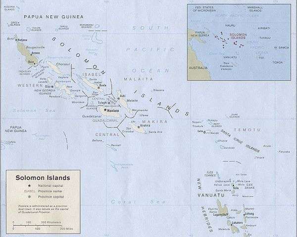
Solomon Islands is a nation in the South Pacific Ocean, that lies east of Papua New Guinea.
Islands
The Solomon Islands consists of an extensive archipelago: Choiseul, the Shortland Islands, the New Georgia Islands, Santa Isabel, the Russell Islands, the Florida Islands, Malaita, Guadalcanal, Sikaiana, Maramasike, Ulawa, Uki, Makira (San Cristobal), Santa Ana, Rennell, Bellona and the Santa Cruz Islands.
The distance between the most western and most eastern islands is about 1,500 km (930 mi). Especially the Santa Cruz Islands, North of Vanuatu, (of which Tikopia is part) are isolated at more than 200 km (120 mi) from the other islands.
Bougainville is geographically part of the Solomon Islands archipelago, but politically an autonomous region of Papua New Guinea.
Geology and ecology
Volcanoes with varying degrees of activity are situated on some of the larger islands, while many of the smaller islands are simply tiny atolls covered in sand and palm trees.
Climate
The climate is tropical, though temperatures are rarely extreme due to cooling winds blowing off the surrounding seas. Daytime temperatures are normally 25 to 32 °C (77 to 90 °F), falling to about 13 to 15 °C (55 to 59 °F) at night. From April to October (the dry season), the southeast trade winds blow, gusting at times up to 30 knots (55 km/h) or more.
November to March is the wet season—the northwest monsoon—typically warmer and wetter. Cyclones arise in the Coral Sea and the area of the Solomon Islands, but they usually veer toward Vanuatu and New Caledonia or down the coast of Australia.
Statistics

Geographic coordinates: 8°00′S 159°00′E / 8.000°S 159.000°E
Map references: Oceania
Area:
total:
28,896 km² (10,985 mi²)
land:
27,986 km² (10,633 mi²)
water:
910 km² (351 mi²)
Land boundaries: 0 km
Coastline: 5,313 km
Maritime claims:
Measured from claimed archipelagic baselines
continental shelf:
200 nmi (230 mi; 370 km)
exclusive economic zone:
200 nmi (230 mi; 370 km)
territorial sea: 12 nmi (14 mi; 22 km)
Terrain: Mostly rugged mountains with some low coral atolls
Elevation extremes:
lowest point:
Pacific Ocean 0 m
highest point:
Mount Popomanaseu 2,332 m (7,651 ft) (not Mount Makarakomburu)
Natural resources: fish, forests, gold, bauxite, phosphates, lead, zinc, nickel
Land use:
arable land:
0.62%
permanent crops:
2.04%
other:
97.34% (2005)
Irrigated land: NA
Natural hazards: Typhoons, but they are rarely destructive; geologically active region with frequent earth tremors; volcanic activity
Environment - current issues: Deforestation; soil erosion; much of the surrounding coral reefs are dead or dying
Environment - international agreements:
party to: Biodiversity, Climate Change, Climate Change-Kyoto Protocol, Desertification, Environmental Modification, Law of the Sea, Marine Dumping, Marine Life Conservation, Ozone Layer Protection, Whaling
signed, but not ratified:
none
Extreme points
This is a list of the extreme points of the Solomon Islands, the points that are farther north, south, east or west than any other location.
- Northernmost point – Ontong Java Atoll, Malaita Province
- Easternmost point – Fatutaka, Santa Cruz Islands, Temotu Province
- Southernmost point – South Reef, Indispensable Reef, Rennell and Bellona Province
- Westernmost point - Mono Island, Treasury Islands, Western Province
See also
- Provinces of the Solomon Islands
- List of mammals of the Solomon Islands}
- Template:Relatives
References
Solomon Islands articles | |||||||
|---|---|---|---|---|---|---|---|
| History |  | ||||||
| Geography |
| ||||||
| Politics | |||||||
| Economy | |||||||
| Society |
| ||||||
| |||||||