Geography of Venezuela


Venezuela is a country in South America, and part of Caribbean South America, bordering the Caribbean Sea and the North Atlantic Ocean,№ between Colombia and Guyana. It is situated on major sea and air routes linking North and South America. Located at the northernmost end of South America, Venezuela has a total area of 916,445 square kilometers and a land area of 882,050 square kilometers, about twice the size of California. Shaped roughly like an inverted triangle, the country has a 2,800-kilometer coastline and is bounded on the north by the Caribbean Sea and the Atlantic Ocean, on the east by Guyana, on the south by Brazil, and on the west by Colombia. Its maritime limits border Trinidad and Tobago, Dominica, the Dominican Republic, Grenada, St. Kitts and Nevis, St. Vincent and the Grenadines, France, the United Kingdom, the Netherlands, and the United States.
Geographic coordinates: 8°00′N 66°00′W / 8.000°N 66.000°W
Topography
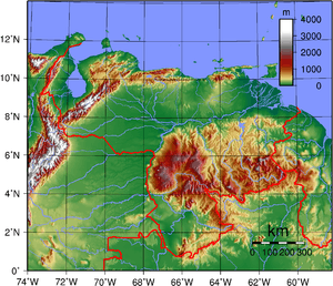
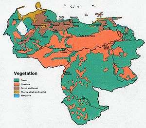
Most observers describe Venezuela in terms of four fairly well-defined regions: the Maracaibo lowlands in the northwest, the northern mountains extending in a broad east-west arc from the Colombian border along the Caribbean Sea, the wide Orinoco plains (llanos) in central Venezuela, and rank highly dissected Guiana highlands in the southeast.
The Maracaibo lowlands form a large spoon-shaped oval bounded by mountains on three HI sides and open to the Caribbean on the north. The area is remarkably flat with only a gentle slope toward the center and away from the mountains that border the region. Lake Maracaibo occupies much of the lower-lying territory. Areas around the southern part of Lake Maracaibo are swampy, and, despite the rich agricultural land and significant petroleum deposits, the area was still thinly populated in the early to mid 1990.
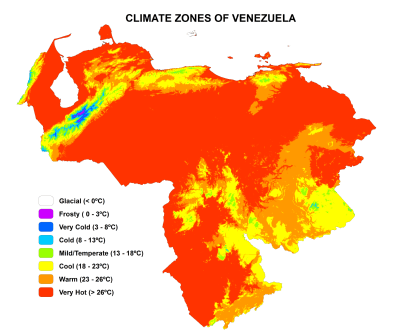
Climate
Although the country lies wholly within the tropics, its climate varies from tropical humid to alpine, depending on the elevation, topography, and the direction and intensity of prevailing winds. Seasonal variations are marked less by temperature than by rainfall. Most of the country has a distinct rainy season; the rainy period (May through November) is commonly referred to as winter and the remainder of the year as summer.
The country falls into four horizontal temperature zones based primarily on elevation. In the tropical zone—below 800 m (2,600 ft)—temperatures are hot, with yearly averages ranging between 26 and 28 °C (79 and 82 °F). The temperate zone ranges between 800 and 2,000 m (2,600 and 6,600 ft) with averages from 12 to 25 °C (54 to 77 °F); many of Venezuela's cities, including the capital, lie in this region. Colder conditions with temperatures from 9 to 11 °C (48 to 52 °F) are found in the cool zone between 2,000 and 3,000 m (6,600 and 9,800 ft). Pastureland and permanent snowfield with yearly averages below 8 °C (46 °F) cover land above 3,000 m (9,800 ft) in the high mountain areas known as the páramos.
Average yearly rainfall amounts in the lowlands and plains range from a semiarid 430 mm (17 in) in the western part of the Caribbean coastal areas to around 1,000 mm (39 in) in the Orinoco Delta. Rainfall in mountainous areas varies considerably; sheltered valleys receive little rain, but slopes exposed to the northeast trade winds experience heavy rainfall. Caracas averages 750 mm (30 in) of precipitation annually, more than half of it falling from June– August.
Hydrography
The Orinoco is by far the most important of the more than 1,000 rivers in the country. Flowing more than 2,500 kilometers to the Atlantic from its source in the Guiana highlands at the Brazilian border, the Orinoco is the world's eighth largest river and the largest in South America after the Amazon. Its flow varies substantially by season, with the high water level in August exceeding by as much as thirteen meters the low levels of March and April. During low water periods, the river experiences high and low tides for more than 100 kilometers upstream from Ciudad Guayana.
For most of the river's course, the gradient is slight. Downstream from its headwaters, it splits into two; one-third of its flow passes through the Brazo Casiquiare (Casiquiare Channel) into a tributary of the Amazon, and the remainder passes into the main Orinoco channel. This passageway allows vessels with shallow drafts to navigate from the lower Orinoco to the Amazon River system after unloading and reloading on either side of two falls on the Orinoco along the Colombian border.
Most of the rivers rising in the northern mountains are flowing southeastward to the Río Apure, a tributary of the Orinoco. From its headwater, the Apure crosses the llanos in a generally eastward direction. Few rivers flow into it from the poorly drained region south of the river and much of this area near the Colombian border is swampland.
The other major Venezuelan river is the fast-flowing Caroní, which originates in the Guiana highlands and flows northward into the Orinoco upstream from Ciudad Guyana. The Caroní is capable of producing as much hydroelectric power as any river in Latin America and has contributed significantly to the nation's electric power production. Electricity generated by the Caroní was one of the factors encouraging industrialization of the northern part of the Guiana highlands and the lower Orinoco valley.
Lake Maracaibo, the largest lake in Latin America, occupies the central 13,500 square kilometers of the Maracaibo lowlands. The low swampy shores of the lake and areas beneath the lake itself hold most of Venezuela's rich petroleum deposits. The lake is shallow, with an average depth of ten meters, and separated from the Caribbean by a series of islands and sandbars. In 1955 a 7.5-meter channel was cut through the sandbars to facilitate shipping between the lake and the Caribbean. The channel also allows salt water to mix with the yellowish fresh water of the lake, making the northern parts brackish and unsuited for drinking or irrigation.
Antipodes
The llanos of Venezuela, along the course of the Apure and Orinoco rivers, are antipodal to central Indonesia, specifically the islands of Bali, Lombok, Sumbawa, Madura, and most of Java. The Amazonian southern lobe of the country, mostly south of the Guiana Highlands, is antipodal to the southeastern corner of Borneo.
Although not overlapping with the large Javanese cities of Jakarta and Bandung, which are opposite Colombia, Java from Semarang east on the north coast, and south of Bandung on the south coast, correlates to Venezuela. The largest Venezuelan city corresponding to Java is San Fernando de Apure (within a couple kilometers of antipodal to the large city of Malang), though San Cristóbal comes close, within a few kilometers of the Javanese coast.
El Tigre is opposite the Wallace Line between Bali and Lombok. Sumbawa corresponds to the Orinoco delta, and almost to Ciudad Guayana.
References
-
 This article incorporates public domain material from the Library of Congress Country Studies website http://lcweb2.loc.gov/frd/cs/.
 - This article incorporates public domain material from the CIA World Factbook website https://www.cia.gov/library/publications/the-world-factbook/index.html.
Venezuela articles | |||||||||||
|---|---|---|---|---|---|---|---|---|---|---|---|
| History |
|  | |||||||||
| Geography |
| ||||||||||
| Politics | |||||||||||
| Economy | |||||||||||
| Society |
| ||||||||||
| |||||||||||