Geography of Houston

According to the United States Census Bureau,[1] the city has a total area of 601.7 square miles (1,558 km2) — 579.4 square miles (1,501 km2) of it is land and 22.3 square miles (58 km2) of it is water. The total area is 3.7 percent water.
Houston is located in the gulf coastal plains biome, and its vegetation is classified as temperate grassland. Much of the city was built on marshes, forested land, swamp, or prairie—all of which can still be seen in surrounding areas.
Much of Houston is very flat, making flooding a recurring problem for its residents. The city stands about 50 feet above sea level—the highest area within city limits being 90 feet.[2] However, coastal subsidence has caused the elevation to drop 10 feet or more in certain areas. The subsidence was caused by extensive use of ground water and the extraction of oil and natural gas. The city turned to ground-level water sources such as Lake Houston which was created in 1953 and Lake Conroe of which Houston owns two-thirds interest.
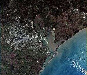
Houston has four major bayous passing through the city: Buffalo Bayou, which runs into downtown and the Houston Ship Channel; and three of its tributaries: Brays Bayou, which runs along the Texas Medical Center; White Oak Bayou, which runs through the Heights and near the northwest area; and Sims Bayou, which runs through the south of Houston and downtown Houston. The ship channel goes past Galveston and into the Gulf of Mexico.
Houston is located 165 miles (266 km) east of Austin,[3] 112 miles (180 km) west of the Louisiana border and 250 miles (400 km) south of Dallas.[4]
Geology
Underpinning Houston's land surface are unconsolidated clays, clay shales, and poorly cemented sands up to several miles deep. The region's geology developed from stream deposits from the erosion of the Rocky Mountains. These sediments consist of a series of sands and clays deposited on decaying organic matter that, over time, transformed into oil and natural gas. Beneath these tiers is a water-deposited layer of halite, a rock salt. The porous layers were compressed over time and forced upward. As it pushed upward, the salt dragged surrounding sediments into dome shapes, often trapping oil and gas that seeped from the surrounding porous sands. This thick rich soil also provides a good environment for rice farming in suburban outskirts that the city continues to grow into near Katy. Evidence of past rice farming is even still evident in developed areas as there is an abundance of rich dark loamy top soil.
The Houston region is generally earthquake-free. While the city of Houston contains 86 mapped and historically active surface faults with an aggregate length of 149 miles (240 km),[5] the clay below the surface precludes the buildup of friction that produces ground shaking in earthquakes. These faults generally move at a smooth rate in what is termed "fault creep."
Cityscape


When Houston was established in 1837, the city's founders—John Kirby Allen and Augustus Chapman Allen—divided it into political geographic districts called "wards." The ward designation is the progenitor of the current-day Houston City Council districts—there are nine in all.
Locations in Houston are generally classified as either being inside or outside Interstate 610, known as the "610 Loop" or simply "The Loop". Inside the loop generally encompasses the central business district, and has come to define an urban lifestyle and state of mind. The appellation “inner looper” carries with it the expectation of someone who appreciates cosmopolitan-style city life. Elizabeth Long, the author of the 2003 book Book Clubs: Women and the Uses of Reading in Everyday Life, wrote that most of the upper middle classes in the 610 Loop live in the southwestern part of the inner city in the areas near Hermann Park, the Houston Museum District, Rice University, and the Texas Medical Center, while some portions of northern Houston and Eastern Houston have been gentrified and also have upper middle classes.[6]
The outlying areas of Houston, the airports and the city's suburbs and enclaves are outside the Loop. Another ring road, Beltway 8 (also known simply as the "Beltway" or as the "Sam Houston Tollway"), encircles the city another 5 miles (8 km) farther out. Parts of Beltway 8 are toll roads, but for most of the route motorists can drive in the adjacent "feeder" or service roads at no charge. Farm to Market Road 1960 (FM 1960) forms a semicircle in northern Houston and is another dividing line.[7] The third ring road, State Highway 99 (also known as the Grand Parkway), is under construction. Long stated that most of the wealthier Houston suburbs are west and north of the central city, while to the southeast the Clear Lake/NASA "[represents] another burgeoning concentration of largely aerospace-related prosperity".[7]
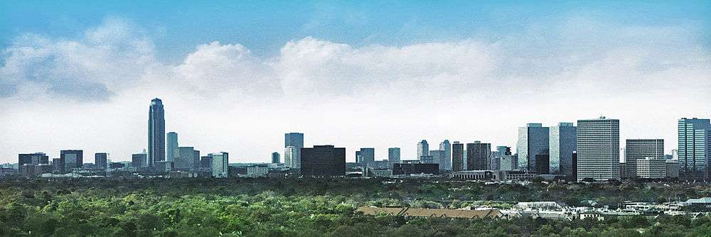
Houston, being the largest city in the United States without zoning laws, has grown in an unusual manner. Rather than a single "downtown" as the center of the city's employment, five additional business districts have grown throughout the inner-city—they are Uptown, Texas Medical Center, Greenway Plaza, Westchase, and Greenspoint. If these business districts were combined, they would form the third-largest downtown in the United States. The city also has the third-largest skyline in the country (after New York City and Chicago), but because it is spread over a few miles, pictures of the city show—for the most part—the main downtown area. The growth of the Greater Houston area has occurred from all directions from the city core.[8]
See also
References
- ↑ US Census Bureau facts
- ↑ U.S. Coast Guard Air Station–Houston: PCS Section. United States Coast Guard
- ↑ Lomax, John Nova. "This Is Texas." Texas Monthly. February 2013. Retrieved on April 30, 2013. "No, the rightful standard-bearer of our state—the city with the greatest number of people, of cultural happenings, of medical facilities, of gangbuster enterprises—is located 165 miles to the east of Texas’s pink-granite dome." - The first part is discussing Houston. The "pink granite dome" is the Texas State Capitol in Austin.
- ↑ Martin, Roland. "Football power in Texas has shifted to Houston." CNN. January 6, 2012. Retrieved on January 7, 2012.
- ↑ Houston Geographic Description. Diane Moser Properties
- ↑ Long, Elizabeth. Book Clubs: Women and the Uses of Reading in Everyday Life. University of Chicago Press, August 1, 2003. ISBN 0226492621, 9780226492629. p. 75.
- 1 2 Long, Elizabeth. Book Clubs: Women and the Uses of Reading in Everyday Life. University of Chicago Press, August 1, 2003. ISBN 0226492621, 9780226492629. p. 76.
- ↑ Long, Elizabeth. Book Clubs: Women and the Uses of Reading in Everyday Life. University of Chicago Press, August 1, 2003. ISBN 0226492621, 9780226492629. p. 75-76.
External links
- Map of Houston city limits, limited purpose annexation, and extraterritorial jurisdiction (Archive (Archive)
- "Super Neighborhoods Map." (Archive." (Archive) City of Houston.