Geography of Cambodia
.svg.png) | |
| Continent | Asia |
|---|---|
| Region | Southeast Asia |
| Coordinates | 13°00′N 105°00′E / 13.000°N 105.000°E |
| Area | Ranked 90th |
| • Total | 181,035 km2 (69,898 sq mi) |
| • Land | 97.50% |
| • Water | 2.50% |
| Coastline | 443 km (275 mi) |
| Borders |
2,530 km (1,572 mi) Laos 555 km (345 mi) Thailand 817 km (508 mi) Vietnam 1,158 km (720 mi) |
| Highest point |
Phnom Aural 1,810 m (5,938 ft) |
| Lowest point |
Gulf of Thailand 0 m (0 ft) |
| Longest river |
Mekong river 486 km (302 mi) |
| Largest lake |
Tonlé Sap 16,000 km2 (6,178 sq mi) |

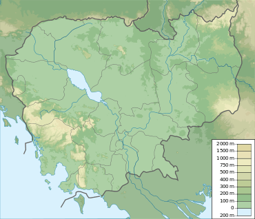
Cambodia is a country in mainland South-east Asia, bordering Thailand, Laos, Vietnam, the Gulf of Thailand and covers a total area of 181,035 km2 (69,898 sq mi). The country is situated in its entirety inside the tropical Indomalayan ecozone[1] and the Indochina Time zone (ICT).[2][3]
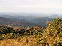
Cambodia's main geographical features are the low lying Central Plain that includes the Tonlé Sap basin, the lower Mekong River flood-plains and the Bassac River plain surrounded by mountain ranges to the north, east, in the south-west and south. The central lowlands extend into Vietnam to the south-east. The south and south-west of the country constitute a 443 km (275 mi) long coast at the Gulf of Thailand, characterized by sizable mangrove marshes, peninsulas, sandy beaches and headlands and bays. Cambodia's territorial waters account for over 50 islands. The highest peak is Phnom Aural, sitting 1,810 metres (5,938 ft) above sea level.[4][5][6]
The landmass is bisected by the Mekong river, which at 486 km (302 mi) is the longest river in Cambodia. After extensive rapids, turbulent sections and cataracts in Laos, the river enters the country at Stung Treng province, is predominantly calm and navigable during the entire year as it widens considerably in the lowlands. The Mekong's waters disperse into the surrounding wetlands of central Cambodia and strongly affect the seasonal nature of the Tonlé Sap lake.[7][8]
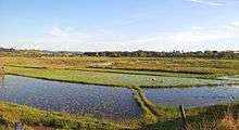
Two third of the country's population live in the lowlands, where the rich sediment deposited during the Mekong's annual flooding makes the agricultural lands highly fertile. As deforestation and over-exploitation affected Cambodia only in recent decades, forests, low mountain ranges and local eco-regions still retain much of their natural potential and although still home to the largest areas of contiguous and intact forests in mainland Southeast Asia, multiple serious environmental issues persist and accumulate, which are closely related to rapid population growth, uncontrolled globalization and inconsequent administration.[9][10][11][12][13]
The majority of the country lies within the Tropical savanna climate zone, as the coastal areas in the South and West receive noticeably more and steady rain before and during the wet season. These areas constitute the easternmost fringes of the south-west monsoon, determined to be inside the Tropical monsoon climate. Countrywide there are two seasons of relatively equal length, defined by varying precipitation as temperatures and humidity are generally high and steady throughout the entire year.[14]
Geological development

Southeast Asia consists of allochthonous continental blocks from Gondwanaland. These include the South China, Indochina, Sibumasu, and West Burma blocks, which amalgamated to form the Southeast Asian continent during the Paleozoic and Mesozoic periods.[15]
The current geological structure of South China and South-East Asia is determined to be the response to the "Indo-sinian" collision in South-East Asia during the Carboniferous.[16] The Indo-Sinian orogeny was followed by extension of the Indo-Chinese block, the formation of rift basins and thermal subsidence during the early Triassic.[17][18][19]
The Indochina continental block, which is separated from the South China Block by the Jinshajiang-Ailaoshan Suture zone, is an amalgamation of the Viet-Lao, Khorat-Kontum, Uttaradit (UTD), and Chiang Mai-West Kachin terranes, all of which are separated by suture zones or ductile shear zones. The Khorat-Kontum terrane, which includes western Laos, Cambodia and southern Vietnam, consists of the Kontum metamorphic complex, Paleozoic shallow marine deposits, upper Permian arc volcanic rocks and Mesozoic terrigenous sedimentary rocks.[20]
The central plains consist mainly of Quaternary sands, loam and clay, as most of the northern mountain regions and the coastal region are largely composed of Cretaceous granite, Triassic stones and Jurassic sandstone formations.[21][22]
General topography


Bowl- or saucer-shaped,[23][24] Cambodia covers 181,035 km2 (69,898 sq mi) in the south-western part of the Indochinese peninsula as its landmass and marine territory is situated entirely within the tropics.
The bowl's bottom represents Cambodia's interior, about 75 percent, consisting of alluvial flood-plains of the Tonlé Sap basin, the lower Mekong River and the Bassac River plain, whose waters feed the large and almost centrally located wetlands. As humans preferably settle in these fertile and easily accessible central lowlands, major transformations and widespread cultivation through wet-rice agriculture have over the centuries shaped the landscape into distinctive regional cultivated lands.[25][26] Domestic plants, such as sugar palms, Coconut trees and banana groves almost exclusively skirt extensive rice paddies, as natural vegetation is confined to elevated lands and near waterways.[27] The Mekong traverses the north to south-east portions of the country, where the low-lying plains extend into Vietnam and reach the South China Sea at the Mekong Delta region.
Cambodia's low mountain ranges - representing the walls of the bowl - remain as the result of only rather recent substantial infrastructural development and economic exploitation - in particular in remote areas - formidably forested.[28] The country is fringed to the north by the Dangrek Mountains plateau, bordering Thailand and Laos, to the north-east by the Annamite Range, in the south-west by the Cardamom Mountains and in the South by the Elephant Mountains. Highlands to the north-east and to the east merge into the Central Highlands and the Mekong Delta lowlands of Vietnam.[29][30]
A heavily indented coastline at the Gulf of Thailand of 443 km (275 mi) length and 60 offshore islands, that dot the territorial waters and locally merge with tidal mangrove marshes - the environmental basis for a remarkable range of marine and coastal eco-regions.[31]
Soils

"Sandy materials cover a large proportion of the landscape of Cambodia, on account of the siliceous sedimentary formations that underlie much of the Kingdom. Mesozoic sandstone dominates most of the basement geology in Cambodia and hence has a dominating influence on the properties of upland soils. Arenosols (sandy soils featuring very weak or no soil development) are mapped on only 1.6% of the land area."
"Sandy surface textures are more prevalent than the deep sandy soils that fit the definition for Arenosols. Sandy textured profiles are common amongst the most prevalent soil groups, including Acrisols and Leptosols. The Acrisols are the most prevalent soil group occupying the lowlands - nearly half of the land area of Cambodia. Low fertility and toxic amounts of aluminium pose limitations to its agricultural use, crops that can be successfully cultivated include rubber tree, oil palm, coffee and sugar cane.[32] The main subgroups are: Gleyic Acrisols (20.5%, Haplic Acrisols (13.3%), Plinthic Acrisol (8.7%) and Ferric Acrisol (6.3%)."[33]
Geographical extremes
- Ta Veaeng District in Rattanakiri marks the northernmost point at 14°41′N 107°32′E / 14.683°N 107.533°E
- The southernmost point lies on Koh Poulo Wai island at 9°54′N 102°53′E / 9.900°N 102.883°E
- Ou Ya Dav District in Rattanakiri marks the easternmost point at 13°22′N 107°37′E / 13.367°N 107.617°E
- Malai in Banteay Meanchey defines Cambodia's westernmost point at 13°53′N 102°33′E / 13.883°N 102.550°E
Regions
Central plain
The vast alluvial and lacustrine interconnected Cambodian flood-plain is a geologically relatively recent depression where the sediments of the Mekong and its tributaries accumulate as waters are subject to frequent course changes.[34] The area covers 25,069 km2 (9,679 sq mi). The Tonlé Sap lake and - river system occupies the lowest area. The Tonle Sap river is a waterway that branches off the Mekong near Phnom Penh in the north-westerly direction and meets the Tonle Sap lake after around 115 km (71 mi). Its waters' flow reverses direction every year, caused by greatly varying amounts of water carried by the Mekong over the course of a year and the impact of monsoonal rains, that coincides with the river's maximum.[35]
The plains of the Mekong and Tonle Sap basin are confined in the North by the Dangrek and Central Annamite Mountains, and to the South by the Cardamom Mountains and Elephant Mountains. The plains completely surround the Tonle Sap Lake in the western half of the country and wind their way through the middle of the country following the course of the Mekong River. The two basins actually form a single body of water, the whole of which effects about 75% of Cambodia’s land cover.[36]
Flow reversal
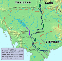
The Mekong river and its tributaries increase water volumes in spring (May) on the northern hemisphere, mainly caused by melting snows. As the Mekong enters Cambodia (over 95% of its waters have already joined the river) it widens and inundates large areas.
"There is extreme hydrodynamic complexity in both time and space and it becomes impossible to measure channel discharge. Water levels, not flow rates and volumes, determine the movement of water across the landscape."[37]
The plain's deepest point - the Tonle Sap - flooded area varies from a low of around 2,700 km2 (1,000 sq mi) with a depth of around 1 meter at the end of the dry season (April) to 26,000 km2 (10,000 sq mi) and a depth of up to 9 meters in October/November. This figure rose to 45,000 km2 (17,000 sq mi) during 2000 when some of the worst flood conditions recorded caused over 800 deaths in Cambodia and Vietnam.
Inflow starts in May/June with maximum rates of flow of around 10,000 m3/s by late August and ends in October/November, amplified by precipitation of the annual monsoon. In November the lake reaches its maximum size. The annual monsoon coincides to cease around this time of the year. As the Mekong river begins its minimum around this time of the year and its water level falls deeper than the inundated Tonle Sap lake, Tonle Sap river and surrounding wetlands, waters of the lake's basin now drains via the Tonle Sap river into the Mekong. As a result the Tonle Sap River (length around 115 km/71 mi) flows 6 months a year South-East (Mekong) to North-West (lake) and 6 month a year in the opposite direction. The mean annual reverse flow volume in the Tonle Sap is 30 km3 (7.2 cu mi), or about half of the maximum lake volume. A further 10% is estimated to enter the system by overland flow from the Mekong.[38][39] The Mekong branches off into several arms near Phnom Penh and reaches Vietnamese territory south of Koh Thom and Loek Daek districts of Kandal Province.
Southern Mountains


This region represents the eastern parts of the original extent of the wet evergreen forests that cover the Cardamom - and Elephant Mountains in South-West Cambodia and along the mountains east of Bangkok in Thailand.[40]
The densely wooded hills receive rainfall of 150–200 inches (3,800–5,000 mm) annually on their western slopes (which are subject to the South-West monsoons) but only 40–60 inches (1,020–1,520 mm) on their eastern - rain shadow - slopes.[41]
The Cardamom/Krâvanh Mountains
Occupying Koh Kong Province and Kampong Speu Province, running in a north-western to south-eastern direction and rising to more than 1,500 meters. The highest mountain of Cambodia, Phnom Aural, at 1,810 meters is located in Aoral District in Kampong Speu Province. The Cardamom Mountains form - including the north-western part of Chanthaburi Province, Thailand, the 'Soi Dao Mountains' - the Cardamom Mountains Moist Forests Ecoregion, that is considered to be one of the most species-rich and intact natural habitats in the region. The climate, size inaccessibility and seclusion of the mountains have allowed a rich variety of wildlife to thrive. The Cardamom and Elephant Mountains remain to be fully researched and documented.[42][43][44][45]
The Elephant Mountains
Chuŏr Phnum Dâmrei - A north-south-trending range of high hills, an extension of the Cardamom/Krâvanh Mountains, in south-eastern Cambodia, rising to elevations of between 500 and 1,000 meters. Extending 70 miles (110 km) north from the Gulf of Thailand, they reach a high point in the Bok Koŭ ridge at Mount Bokor (3,547 feet [1,081 m]) near the sea.[46][47][48][49]
To the south-west of the Southern mountain ranges extends a narrow coastal plain that contains the Kampong Saom Bay area and the Sihanoukville peninsula, facing the Gulf of Thailand.
Northern Mountains
The Dangrek Mountains
A forested range of hills averaging 1,500–2,000 feet (450–600 m), dividing Thailand from Cambodia, mainly formed of massive sandstone with slate and silt. A few characteristic basalt hills are located on the northern side of the mountain chain. This east–west-trending range extends from the Mekong River westward for approximately 200 miles (320 km), merging with the highland area near San Kamphaeng, Thailand. Essentially the southern escarpment of the sandstone Khorat Plateau of northeastern Thailand, the Dângrêk range slopes gradually northward to the Mun River in Thailand but falls more abruptly in the south to the Cambodian plain. Its highest point is 2,497 feet (761 m). The watershed along the escarpment in general terms marks the boundary between Thailand and Cambodia, however there are exceptions. The region is covered in dry evergreen forest, mixed dipterocarp forest, and deciduous dipterocarp forests. Tree species like Pterocarpus macrocarpus, Shorea siamensis and Xylia xylocarpa var. kerrii dominate. Illegal logging are issues on both, the Thai as well as on the Cambodian side, leaving large hill stretches denuded, vulnerable tree species such as Dalbergia cochinchinensis have been affected.[50] Forest fires are common during the dry season.[51]

Annamite Range
Lying to the east of the Mekong River, the long chain of mountains called the Annamite Mountains of Indochina and the lowlands that surround them make up the Greater Annamites ecoregion. Levels of rainfall vary from 1,500 - 3,850 mm annually. Mean annual temperatures are about 20 °C. This eco-region contains some of the last relatively intact moist forests in Indochina. Moisture-laden monsoon winds, that blow in from the Gulf of Tonkin ensure permanent high air humidity. Plants and animals adapted to moist conditions, to seek refuge here and evolve into highly specialized types that are found nowhere else on Earth.[52][53][54]
Ethnically diverse More than 30 ethnic groups of indigenous people live in the Annamites, each with their distinctive and traditional music, language, dress and customs. The natural resources of the Greater Annamites are vital to all of these people.[55]
Eastern Highlands
Tall grasses and deciduous forests cover the ground east of the Mekong River in Mondulkiri, where the transitional plains merge with the eastern highlands at altitudes from 200–1000 meters. The landscape has suffered from rubber farming, logging and particularly mining, although sizable areas of pristine jungle survive, which are home to rare and endemic wildlife.[56]
Coast
Cambodia's coastal area covers 17,237 km2 (6,655 sq mi), distributed among 4 provinces: Sihanoukville province, Kampot province, Koh Kong province, and Kep province. The total length of the Cambodian coastal area has been disputed over the years. The generally accepted length is 440 kilometers, a 1997 survey by the DANIDA organization set the length at 435 km (270 mi), and the Oil Authority in 1973 determined the coast to be 450 km (280 mi) long.[57] The Food and Agriculture Organization claims a length of 557 km (346 mi) in of its studies.[58]
The southern mountain ranges drain to the south and west towards the shallow sea. Sediments on the continental shelf are the basis for extensive mangroves marshes, in particular in the Koh Kong province and the Ream National Park.[39][59]
Islands
Cambodia’s islands fall under administration of the 4 coastal provinces.[60] "There are 60 islands in Cambodia's coastal waters. They include 23 in Koh Kong province, 2 in Kampot province, 22 in Sihanoukville and 13 in Kep city.[sic]"[61] Most islands are, apart from the two small groups of the outer islands, in relative proximity to the coast. The islands and the coastal region of Koh Kong Province are mainly composed of upper Jurassic and lower Cretaceous sandstomne massives.[21] The north-westernmost islands near and around the Kaoh Pao river delta (Prek Kaoh Pao) area are to a great extent sediments of estuaries and rivers, very flat and engulfed in contiguous mangrove marshes.[62]

Climate


Cambodia's climate, like that of much of the rest of mainland Southeast Asia is dominated by monsoons, which are known as tropical wet and dry because of the distinctly marked seasonal differences. The monsoonal air-flows are caused by annual alternating high pressure and low pressure over the Central Asian landmass. In summer, moisture-laden air—the southwest monsoon—is drawn landward from the Indian Ocean. The flow is reversed during the winter, and the northeast monsoon sends back dry air. The southwest monsoon brings the rainy season from mid-May to mid-September or to early October, and the northeast monsoon flow of drier and cooler air lasts from early November to March. Temperatures are fairly uniform throughout the Tonlé Sap Basin area, with only small variations from the average annual mean of around 25 °C (77.0 °F).
The maximum mean is about 30 °C ; the minimum mean, about 24 °C. Maximum temperatures of higher than 32 °C, however, are common and, just before the start of the rainy season, they may rise to more than 38 °C. Minimum night temperatures sporadically fall below 20 °C.[63] in January, the coldest month. May is the warmest month - although strongly influenced by the beginning of the wet season, as the area constitutes the easternmost fringe of the south-west monsoon. Tropical cyclones only rarely cause damage in Cambodia.[64][65]
The total annual rainfall average is between 1,000 and 1,500 millimeters (39.4 and 59.1 in), and the heaviest amounts fall in the southeast. Rainfall from April to September in the Tonlé Sap Basin-Mekong Lowlands area averages 1,300 to 1,500 millimeters (51.2 to 59.1 in) annually, but the amount varies considerably from year to year. Rainfall around the basin increases with elevation. It is heaviest in the mountains along the coast in the southwest, which receive from 2,500 millimeters (98.4 in) to more than 5,000 millimeters (196.9 in) of precipitation annually as the southwest monsoon reaches the coast. This area of greatest rainfall, however, drains mostly to the sea; only a small quantity goes into the rivers flowing into the basin. Relative humidity is high throughout the entire year; usually exceeding 90 percent. During the dry season daytime humidity rates average around 50 percent or slightly lower, climbing to about 90 percent during the rainy season.[33][66]
| Climate data for Sihanoukville, Cambodia | |||||||||||||
|---|---|---|---|---|---|---|---|---|---|---|---|---|---|
| Month | Jan | Feb | Mar | Apr | May | Jun | Jul | Aug | Sep | Oct | Nov | Dec | Year |
| Average high °C (°F) | 31.3 (88.3) |
31.2 (88.2) |
32.1 (89.8) |
33.7 (92.7) |
32.3 (90.1) |
31.2 (88.2) |
30.0 (86) |
30.8 (87.4) |
30.8 (87.4) |
30.8 (87.4) |
31.2 (88.2) |
31.7 (89.1) |
31.43 (88.57) |
| Average low °C (°F) | 23.9 (75) |
24.6 (76.3) |
25.4 (77.7) |
25.0 (77) |
26.8 (80.2) |
26.3 (79.3) |
25.9 (78.6) |
25.1 (77.2) |
25.2 (77.4) |
24.7 (76.5) |
24.4 (75.9) |
23.5 (74.3) |
25.07 (77.12) |
| Average precipitation mm (inches) | 28.3 (1.114) |
25.2 (0.992) |
50.3 (1.98) |
124.8 (4.913) |
207.3 (8.161) |
252.7 (9.949) |
341.4 (13.441) |
377.2 (14.85) |
320.6 (12.622) |
290.4 (11.433) |
138.2 (5.441) |
54.4 (2.142) |
2,210.8 (87.038) |
| Source: world weather online[67] | |||||||||||||
| Climate data for Phnom Penh, Cambodia | |||||||||||||
|---|---|---|---|---|---|---|---|---|---|---|---|---|---|
| Month | Jan | Feb | Mar | Apr | May | Jun | Jul | Aug | Sep | Oct | Nov | Dec | Year |
| Average high °C (°F) | 31.3 (88.3) |
32.2 (90) |
34.1 (93.4) |
35.7 (96.3) |
34.3 (93.7) |
33.2 (91.8) |
32.0 (89.6) |
32.8 (91) |
32.8 (91) |
31.8 (89.2) |
30.2 (86.4) |
30.7 (87.3) |
32.59 (90.67) |
| Average low °C (°F) | 23.9 (75) |
23.6 (74.5) |
25.4 (77.7) |
26.0 (78.8) |
26.8 (80.2) |
26.3 (79.3) |
26.9 (80.4) |
25.1 (77.2) |
25.2 (77.4) |
25.7 (78.3) |
24.4 (75.9) |
23.5 (74.3) |
25.23 (77.42) |
| Average precipitation mm (inches) | 0.0 (0) |
11.3 (0.445) |
6.5 (0.256) |
0.0 (0) |
4.8 (0.189) |
34.8 (1.37) |
16.1 (0.634) |
40.3 (1.587) |
60.5 (2.382) |
65.8 (2.591) |
22.7 (0.894) |
3.2 (0.126) |
266 (10.474) |
| Source: world weather online[68] | |||||||||||||
| Climate data for Senmonorom, Cambodia | |||||||||||||
|---|---|---|---|---|---|---|---|---|---|---|---|---|---|
| Month | Jan | Feb | Mar | Apr | May | Jun | Jul | Aug | Sep | Oct | Nov | Dec | Year |
| Average high °C (°F) | 26.0 (78.8) |
27.0 (80.6) |
25.0 (77) |
19.0 (66.2) |
25.0 (77) |
25.0 (77) |
27.0 (80.6) |
25.0 (77) |
24.0 (75.2) |
25.0 (77) |
24.0 (75.2) |
27.0 (80.6) |
24.9 (76.85) |
| Average low °C (°F) | 14.0 (57.2) |
13.0 (55.4) |
17.0 (62.6) |
13.0 (55.4) |
18.0 (64.4) |
19.0 (66.2) |
20.0 (68) |
19.0 (66.2) |
18.0 (64.4) |
18.0 (64.4) |
16.0 (60.8) |
15.0 (59) |
16.7 (62) |
| Average precipitation mm (inches) | 30.0 (1.181) |
48.0 (1.89) |
21.0 (0.827) |
144.0 (5.669) |
90.0 (3.543) |
114.0 (4.488) |
282.0 (11.102) |
555.0 (21.85) |
192.0 (7.559) |
234.0 (9.213) |
129.0 (5.079) |
39.0 (1.535) |
1,878 (73.936) |
| Source: world weather online[69] | |||||||||||||
Hydrology


The Mekong River and its tributaries comprise one of the largest river systems in the world.[70] The central Tonle Sap - Great Lake has several input rivers, the most important being the Tonle Sap river during the rainy season, which contributes 62 percent of the total water supply. The other rivers in the sub-basin and direct rainfall on the lake contribute the remaining 38 percent. Other major rivers are the Sen river, Sreng river, Pursat (Pouthisat) river, Sisophon river, Mongkul Borey river, and Sangker river.[71][72]
Except for the smaller rivers in the southeast, most of the major rivers and river systems in Cambodia drain into the Tonle Sap or into the Mekong River. The Cardamom Mountains and Elephant Range form a separate drainage divide. To the east the rivers flow into the Tonle Sap, as in the south-west rivers flow into the Gulf of Thailand. Toward the southern slopes of the Elephant Mountains, small rivers flow south-eastward on the eastern side of the divide.
The Mekong River flows southward from the Cambodia-Laos border to a point below Kratie city, where it turns west for about 50 kilometers and then turns southwest to Phnom Penh. Extensive rapids run above Kratie city. From Kampong Cham Province the gradient slopes very gently, and inundation of areas along the river occurs at flood stage—June through November—through breaks in the natural levees that have built up along its course. At Phnom Penh four major water courses meet at a point called the Chattomukh (Four Faces). The Mekong River flows in from the northeast and the Tonle Sap, a river emanating from the Tonle Sap—flows in from the northwest. They divide into two parallel channels, the Mekong River proper and the Bassac River, and flow independently through the delta areas of Cambodia and Vietnam to the South China Sea.
The flow of water into the Tonle Sap is seasonal. In spring, the flow of the Mekong River, fed by monsoon rains, increases to a point where its outlets through the delta cannot handle the enormous volume of water. At this point, the water pushes northward up the Tonle Sap river and empties into the Tonle Sap lake, thereby increasing the size of the lake from about 2,590 square kilometers to about 24,605 square kilometers at the height of the flooding. After the Mekong's waters crest — when its downstream channels can handle the volume of water — the flow reverses, and water flows out of the engorged lake.
As the level of the Tonle Sap retreats, it deposits a new layer of sediment. The annual flooding, combined with poor drainage immediately around the lake, transforms the surrounding area into marshlands, unusable for agricultural purposes during the dry season. The sediment deposited into the lake during the Mekong's flood stage appears to be greater than the quantity carried away later by the Tonle Sap River. Gradual silting of the lake would seem to be occurring; during low-water level, it is only about 1.5 meters deep, while at flood stage it is between 10 and 15 meters deep.[73][74]
Vegetation & ecoregions

Cambodia has one of the highest levels of forest cover in the region as the interdependence of Cambodia’s geography and hydrology makes it rich in natural resources and biological diversity - among the bio-richest countries in Southeast Asia. The Royal Government of Cambodia estimates Cambodia contains approximately 10.36 million hectares of forest cover, representing approximately 57.07% of Cambodia’s land area (2011).[75] On the contrary, international observers and independent sources provide rather different numbers. Consensus permeates, as most sources agree, that deforestation, loss of seasonal wetlands and habitat destruction - among countless minor factors - correlates with the absence of strict administrative control and indifference in law enforcement - not only in Cambodia but the entire region.[76][77][78]
Figures and assessments are numerous as are available sources. as seen in numbers below, which provide a wide range for interpretation. About 69,000 ha (1%) of forest cover is planted forest. Overall Cambodia’s forests contain an estimated 464 million metric tonnes of carbon stock in living forest biomass.[79] Approximately 40% of Cambodia’s Forests have some level of protection, while one of the Cambodia Millennium Development Goals targets is to achieve a 60% forest cover by 2015.[80][81]
| Cambodia Forest Cover, 2002 | |||||||||||||||||||||
| Forest Types | Area (ha) | Percentage | |||||||||||||||||||
|---|---|---|---|---|---|---|---|---|---|---|---|---|---|---|---|---|---|---|---|---|---|
| Evergreen Forest | 3,720,506 | 20.49 | |||||||||||||||||||
| Semi-evergreen forest | 1,455,190 | 8.01 | |||||||||||||||||||
| Deciduous forest | 4,833,861 | 26.62 | |||||||||||||||||||
| Other forest | 1,094,726 | 6.03 | |||||||||||||||||||
| Non-forest | 7,056,388 | 38.85 | |||||||||||||||||||
| Source: United Nations [82] | |||||||||||||||||||||
| Cambodia Forest Cover, 2002 | |||||||||||||||||||||
| Forest Types | Area (ha) | Percentage | |||||||||||||||||||
|---|---|---|---|---|---|---|---|---|---|---|---|---|---|---|---|---|---|---|---|---|---|
| forests - commercially unattractive | 3.200.000 | 30 | |||||||||||||||||||
| forests - commercially attractive | 630.000 | 6 | |||||||||||||||||||
| flooded forest - cut and/or converted | 30 | ||||||||||||||||||||
| flooded forest - healthy | 450.000 | ||||||||||||||||||||
| lost area | 550.000 | 55 | |||||||||||||||||||
| Source: CAMBODIA DEVELOPMENT RESOURCE INSTITUTE [83] | |||||||||||||||||||||
According to the Forestry Administration statistics, a total of 380,000 hectares of forest were cleared between 2002 and 2005/2006 - a deforestation rate of 0.5% per year. The main cause of deforestation has been determined to be large-scale agricultural expansions.[84][85]
Southern Annamites Montane Rain Forests ecoregion
The Southern Annamites Montane Rain Forests ecoregion of the montane forests of Kontuey Nea, "the dragon's tail" in the remote north-west of Cambodia, where the boundaries of Cambodia, Laos, and Vietnam meet, is remarkably rich in biodiversity. The relatively intact forests occupy a broad topographic range - from lowlands with wet evergreen forests to montane habitats with evergreen hardwood and conifer forests. The complex geological, topographic and climatic ( rainfall and temperature ) facets that characterize the region make forest structure and composition unique and very variable. There is a unusually high number of near-endemic and endemic species among the many species to be found in the area,. The entire eco-region has a size of 94,000 km2 (36,294 sq mi).[86][87][88]
The Great Lake ecosystem
_(15607560356).jpg)
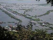
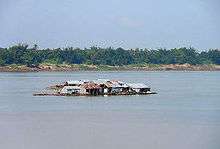
The Tonle Sap, also known as the Great Lake in central Cambodia is the largest freshwater lake in Southeast Asia and one of the richest inland fishing grounds in the world. The Lake functions as a natural flood water reservoir for the Mekong system as a whole and therefore is an important source of water for the Mekong Delta during the dry season.[89] The ecosystem has developed as a result of the Mekong’s seasonal flow fluctuations. A belt of freshwater mangroves known as the "flooded forest" surrounds the lake. The floodplains in turn are surrounded by low hills, covered with evergreen seasonal tropical forest with substantial dipterocarp vegetation or deciduous dry forest. The eco-region consists of a mosaic of habitats for a great number of species.[90] The forest gradually yields to bushes and finally grassland with increasing distance from the lake.
Henri Mouhot: "Travels in the Central Parts of Indo-China" 1864
"During more than five months of the year, the great lake of Cambodia, Touli-Sap, covers an immense space of ground: after that period there is a diminution in depth owing to the great evaporation, but its width remains nearly unaltered. Although its waters increase in volume during the rainy season, these are not swelled by the streams from the mountains on its western boundary, but by the strength of the current from the Mekon which pours into it its overflow.[sic]"[91]
On higher quality soils or at higher elevation, areas of mixed deciduous forest and semi-evergreen forests[92] occur. This variety of vegetation types accounts for the quantity and diversity of species of the Great Lake ecosystem. Interlocking forest, - grassland and marshland patches provide the many facets and refugiae for the abundant local wildlife.[93][94]
The lake’s flooded forest and the surrounding floodplains are of utmost importance for Cambodia's agriculture as the region represents the cultural heart of Cambodia, the center of the national freshwater fishery industry - the nation's primary protein source.[95] Threats to the lake include widespread pollution, stress through growth of the local population which is dependent on the lake for subsistence and livelihood, over-harvesting of fish and other aquatic - often endangered - species, habitat destruction and potential changes in the hydrology, such as the construction and operation of dams, that disrupt the lake's natural flood cycle. However, concerns that the lake is rapidly filling with sediment seem - according to studies[96] - to be unfounded at the present time.[97]
Wetlands
Wetlands cover more than 30 per cent of Cambodia. In addition to the Mekong River and the Tonle Sap floodplain there are the Stung Sen River and the coastal Stung Koh Pao - and Stung Kep estuaries of Koh Kong Province and Kep Province. The freshwater wetlands of Cambodia represent one of the most diverse ecosystems worldwide.[98] The area’s extensive wetland habitats are the product of the annual Mekong maximum, the simultaneous wet season and the drainage paths of a number of minor rivers. See also:Geography of Cambodia#Hydrology The numerous and varied wetlands are Cambodia's central and traditional settlement area, the productive environments for rice cultivation, freshwater fisheries, other forms of agriculture and aquaculture and the constantly growing tourism sector.[99] Considering the eco-region's importance, a variety of plans for local wetland management consolidation exist[100][101] with varying degrees of completion.[102]
Coastal habitats

The Cambodian coastline consists of 60,000 ha of some 30 species of mangroves - among the most biologically diverse wetlands on earth.[103] The most pristine mangrove forests are found in Koh Kong Province. In addition to mangroves, sea-grass beds extend throughout the coastal areas, especially in Kampot Province, the Prek Kompong Saom Bay Delta and Kep municipal waters. The meadows are highly productive, but few animals feed directly on the grasses. Those that do tend to be vertebrates such as sea turtles, dabbling ducks and geese.[104][105][106]
"With their roots deep in mud, jagged and gnarled mangrove trees are able to grow in the brackish wetlands between land and sea where other plant life cannot survive. The trees offer refuge and nursery grounds for fish, crabs, shrimp, and mollusks. They are nesting - and migratory sites for hundreds of bird species. They also provide homes for monkeys, lizards, sea turtles, and many other animals as well as countless insects. "[103]
"Until relatively recently, the mangroves of Koh Kong, Cambodia have remained relatively intact. This is partly because of the region’s location — it is an isolated, inaccessible place — and because decades of war and conflict perversely protected the forests from over-exploitation. Local people, however, tended to use the forest's sustainability, for food, fuel, medicine, building materials, and other basic needs. "[103]
Fauna

Cambodia is home to a wide array of wildlife. There are 212 mammal species, 536 bird species, 176 reptile species (including 89 subspecies), 850 freshwater fish species (Tonlé Sap Lake area), and 435 marine fish species. Many of the country's species are recognized by the IUCN or World Conservation Union as threatened, endangered, or critically endangered due to deforestation and habitat destruction, poaching, illegal wildlife trade, farming, fishing, and unauthorized forestry concessions. Intensive poaching may have already driven Cambodia's national animal, the Kouprey, to extinction. Wild tigers, Eld's deer, wild water buffaloes and hog deer are at critically low numbers.[107][108][109]
Protected areas
"The 1993 Royal Decree on the Protection of Natural Areas recognized 23 protected areas, which at the time covered more than 18% of the country’s total land area."[110]
- Natural parks (sometimes described as ‘national parks’)
- Wildlife reserves
- Protected scenic view areas (sometimes described as ‘protected landscapes’)
- Multi-purpose areas.
Political and human geography
| Life in Cambodia |
|---|
|
Cambodia borders Vietnam over a length of 1,228 km, Thailand over a length of 803 km and Laos over a length of 541 km, with 2,572 km in total and an additional 443 km of coastline. The capital (reach thani) and provinces (khaet) of Cambodia are first-level administrative divisions. Cambodia is divided into 25 provinces including the capital.
Municipalities and districts are the second-level administrative divisions of Cambodia. The provinces are subdivided into 159 districts and 26 municipalities. The districts and municipalities in turn are further divided into communes (khum) and quarters (sangkat).[111]
Land use
Cambodia, Laos and Vietnam have experienced major changes in land use and land cover over the last two decades. The emergence from cold war rivalries and recent major economic reforms result in a shift from subsistence agrarian modes of production to market-based agricultural production and industrialized economies, which are heavily integrated into regional and global trade systems.[112]
| Land Use in Cambodia - Sources: World Bank,[113] FAO[114] UN[115] | |||||||||||||||||||||
|---|---|---|---|---|---|---|---|---|---|---|---|---|---|---|---|---|---|---|---|---|---|
| 1990 | 2000 | 2002 | 2010 | ||||||||||||||||||
| Agricultural land (km2) in Cambodia | 44550.0 | 47700.0 | |||||||||||||||||||
| Agricultural land (% of land area) in Cambodia | 25.2 | 27.0 | 23.0 | ||||||||||||||||||
| Arable land (hectares) in Cambodia | 3695000.0 | 3700000.0 | |||||||||||||||||||
| Arable land (hectares per person) in Cambodia | 0.4 | 0.3 | |||||||||||||||||||
| Arable land (% of land area) in Cambodia | 20.9 | 21.0 | |||||||||||||||||||
| Permanent cropland (% of land area) in Cambodia | 0.6 | 0.8 | |||||||||||||||||||
| Forest area (km2) in Cambodia | 129460.0 | 115460.0 | 100940.0 | ||||||||||||||||||
| Forest area (% of land area) in Cambodia | 73.3 | 65.4 | 54.0 | 57.2 | |||||||||||||||||
Regional divisions
Cambodia's boundaries were for the most part based upon those recognized by France and by neighboring countries during the colonial period. The 800-kilometer boundary with Thailand runs along the watershed of the Dangrek Mountains, although only in its northern sector. The 541-kilometer border with Laos and the 1,228-kilometer border with Vietnam result from French administrative decisions and do not follow major natural features. Border disputes have broken out in the past and do persist between Cambodia and Thailand as well as between Cambodia and Vietnam.[116][117][118][119]


|
Area and boundaries

Area:
total:
181,035 km²
land:
176,515 km²
water:
4,520 km²
Maritime claims:
territorial sea:
12 nmi (13.8 mi; 22.2 km)
contiguous zone:
24 nmi (27.6 mi; 44.4 km)
exclusive economic zone:
200 nmi (230.2 mi; 370.4 km)
continental shelf:
200 nmi (230.2 mi; 370.4 km)
Elevation extremes:
lowest point:
Gulf of Thailand 0 m
highest point:
Phnum Aoral 1,810 m[121]
Border disputes
Lakes
- Tonlé Sap Lake
- Yak Loum Crater Lake – Ratanakiri
Natural resources
- Oil and natural gas - In addition to the four parts of mining project, the oilfield, Block A was discovered in 2005 and located 200 km offshore in the gulf of Thailand Chevron would operate and hold a 30% interest Block A which cover 4,079 KM². It is expected to get 30-year-production permit in the second quarter of 2011.
In late 1969, the Cambodian government granted a permit to a French company to explore for petroleum in the Gulf of Thailand. By 1972 none had been located, and exploration ceased when the Khmer Republic (see Appendix B) fell in 1975. Subsequent oil and gas discoveries in the Gulf of Thailand and in the South China Sea, however, could spark renewed interest in Cambodia's offshore area, especially because the country is on the same continental shelf as its Southeast Asian oil-producing neighbors.[122]
- Timber
- Dipterocarpus alatus (chheuteal tan) Sawnwood, veneer, plywood
- Anisoptera glabra (mersawa, phdiek) Sawnwood, veneer, plywood
- Hopea odorata (koki) Sawmilling, construction (bridges, boats)
- Shorea vulgaris (choë(r) chông) Sawmilling, construction (housing)
- Tarrietia javanica Sawnwood (decorative, furniture)[123]
- Gemstones - Gemstone areas are located in Samlot district of Battambang, Paillin, Ratanakkiri, and Takeo Province
- Iron ore - Hermatite (Fe203); Magnetite (Fe304); Limonite (2Fe203, 3H2O) - was found in two areas, one located in Phnom Deck and the others located in Koh Keo of Preah Vihear Province, and Thalaborivath of Stung Treng Province. According to General Department of Mineral, the total iron reserves in Phnom Deck area are estimated at 5-6 million tons and other deposits may add 2-3 million tons.
- Gold - Gold deposit was found in four provinces: Kampong Cham (The Rumchek in Memot area), Kampong Thom (Phnom Chi area), Preah Vihear (Phnom Deck in Roveing district), Ratanakiri (Oyadav district) and Mondulkiri
- Bauxite – was found in Battambang Province and Chhlong district in Mondulkiri Province.
- Antimony (Sb) – found in Sre Peang area, Pursat Province
- Chromium (Cr) – found in Sre Peang area, Pursat Province
- manganese
- phosphates
- Hydro-power - Hydroelectric dams: Lower Se San 2 Dam, Stung Treng Dam
- Arable land
- Marine resoures[124][125]
Total renewable water resources:
- 476.1 km3 (114.22 cu mi) (2011)
Freshwater withdrawal (domestic/industrial/agricultural):
- Total: 2.18 km3 or 0.523 cu mi/yr (4%/2%/94%)
- Per capita: 159.8 km3 or 38.3 cu mi/yr (2006)
Environmental issues


Natural hazards
- Monsoonal rains (June to November)
- Mekong flooding[126]
- Occasional droughts
Human impact
"Environmental and natural resources (ENR) in Cambodia are threatened by short-sighted over-exploitation on an increasing and threatening scale. This reduces the Country’s overall natural capital, yet whilst great benefits flow to the few; equally great burdens fall on the many."[127]
Issues
- Illegal logging activities throughout the country[128]
- rubber tree mono-cultures and strip mining for gold in the eastern highlands
- gem mining in the western region along the border with Thailand[129]
- destruction of mangrove swamps threatens natural fisheries, illegal fishing and over-fishing[130][131]
- large scale sand mining in river beds and estuaries of Koh Kong's mangrove marshes affects tidal balance[132]
A nascent environmental movement has been noticed by NGO's - and it is gaining strength, as the example of local resistance against the building of a Chinese hydro-electric dam in the Areng Valley shows.[133]
Consequences
- Flooding[134]
- Deforestation
- Soil erosion in rural areas
- Declining fish stocks
- Decreasing access to clean water
- Habitat loss and declining biodiversity
International agreements and conventions
Cambodia is party to the following treaties:
- Convention on Biological Diversity[135]
- Convention on Climate Change[136]
- MARPOL 73/78[137]
- Tropical Timber 94[138][139]
- Ramsar Convention on Wetlands[140]
Signed, but not ratified:
See also
References
- ↑ "Land and Resource of Cambodia". Ministry of Rural Development. January 26, 2009. Retrieved June 1, 2015.
- ↑ "ICT – Indochina Time (Standard Time)". Time and Date AS. Retrieved October 28, 2015.
- ↑ "GEOGRAPHY". The Royal Embassy of Cambodia. Retrieved June 7, 2016.
- ↑ "Cambodia Study Area" (PDF). Regional Resource Centre for Asia and the Pacific(RRC.AP). Retrieved May 13, 2015.
- ↑ "Cambodia Environment Outlook - NATURAL AND ENVIRONMENTAL RESOURCES - Geography and Climate" (PDF). United Nations Environment Programme. Retrieved May 17, 2015.
- ↑ "Cambodia". Google Books. Retrieved October 31, 2015.
- ↑ "Information Resources - Southern Part". Mekong River Commission. May 11, 2015. Retrieved May 14, 2015.
- ↑ "World Geographical Dictionary On Cambodia six distinct terrestrial eco‐regions in Cambodia have been recognized" (PDF). Water Hazard and Risk management. May 31, 2013. Retrieved June 26, 2015.
- ↑ "Rain Forests of the World". Lizas Reef. Retrieved May 13, 2015.
- ↑ "Environmental issues in Cambodia". Rainforests Mongabay. August 15, 2014. Retrieved May 13, 2015.
- ↑ "Officials Unable to Explain Mystery Ships". The Cambodia Daily. November 6, 2015. Retrieved November 6, 2015.
- ↑ "Conservation activists arrested in Koh Kong". Phnom Penh Post. August 18, 2015. Retrieved June 21, 2016.
- ↑ "In Cambodia, quality wood makes for murder". CBSNews. November 13, 2012. Retrieved October 12, 2016.
- ↑ Climate and Weather. Tourism of Cambodia. Retrieved May 18, 2015.
- ↑ "Late Palaeozoic and Mesozoic Ecosystems in SE Asia". Google Books. Retrieved May 13, 2015.
- ↑ "Late Palaeozoic–Early Mesozoic geological features of South China: Response to the Indosinian collision events in Southeast Asia" (PDF). Inria France. Retrieved May 13, 2015.
- ↑ The Geology of Thailand. Google Books. Retrieved May 13, 2015.
- ↑ "The Indo-Asian continental collision: A 3-D viscous model" (PDF). University of Missouri. Retrieved May 13, 2015.
- ↑ "Note sur la géologie du Cambodge et du Bas-Laos". Jubilothèque. Retrieved May 13, 2015.
- ↑ "Structural and geochronological constraints on the tectonic evolution of the Dulong-Song Chay tectonic dome in Yunnan province, SW China" (PDF). China University of Geosciences. Retrieved May 13, 2015.
- 1 2 "Geological Map of Cambodia, 1991, 1:500,000". Behance. June 21, 2012. Retrieved May 13, 2015.
- ↑ "Quantitative bedrock geology of east and Southeast Asia". Wiley Online Library. January 17, 2004. Retrieved May 13, 2015.
- ↑ "Cambodia - Land and People". Sandbox Networks, Inc. Retrieved June 6, 2016.
- ↑ "Volunteer and Adventures in Cambodia - Gerneral Info". Volunteer and Adventures in Cambodia. Retrieved May 14, 2015.
- ↑ "Rice in the Cambodian economy, past and present - Khmer farmers have been growing rain fed rice for at least 2,000 yr, possibly longer in the case of upland rice. Historians believe that rice - growing technologies may have been imported..." (PDF). Cambodia - IRRI - Australia Project. Retrieved July 3, 2015.
- ↑ "The Killing of Cambodia: Geography, Genocide and the Unmaking of Space James A. Tyner - Chapter 1". Google Books. Retrieved June 6, 2015.
- ↑ "Rice farming in Cambodia: A beginner's guide". MicroWorld. July 11, 2011. Retrieved May 14, 2015.
- ↑ "Terrestrial Ecoregions of the Indo-Pacific: A Conservation Assessment". Google Books. Retrieved May 27, 2015.
- ↑ "Cambodia Geography". Angkor Temple Guides. Retrieved June 6, 2015.
- ↑ "Cambodia - Topography". U.S. Library of Congress. Retrieved June 7, 2015.
- ↑ "Cambodia - Location and size, Territories and dependencies, Climate, Topographic regions, Oceans and seas". Encyclopedia of the Nations. Retrieved May 27, 2015.
- ↑ "World reference base for soil resources". FOOD AND AGRICULTURE ORGANIZATION OF THE UNITED NATIONS Rome, 1998. Retrieved June 7, 2015.
- 1 2 "Management of tropical sandy soils for sustainable agriculture". FAO Document Repository. Retrieved May 14, 2015.
- ↑ "THE LOWER REACHES AND DELTA REGIONS". MRC Mekong. Retrieved May 14, 2015.
- ↑ "Cambodian Plain definition of Cambodian Plain". Free Online Encyclopedia. Retrieved June 6, 2015.
- ↑ "Description of Ecological Factors in Cambodia" (PDF). Cambodia Tree Seed Project. Retrieved May 20, 2015.
- ↑ "Overview of the Hydrology of the Mekong Basin" (PDF). Mekong Info. October 1, 2005. Retrieved May 12, 2015.
- ↑ "Tonle Sap Cambodia - River Lake". Tonle Sap. Retrieved May 12, 2015.
- 1 2 "State of water : Cambodia". WEPA. Retrieved May 12, 2015.
- ↑ "Southeastern Asia: Southern Cambodia stretching into Thailand and Vietnam". WWF. Retrieved May 12, 2015.
- ↑ "Cardamom Mountains rain forests". Global Species. Retrieved May 12, 2015.
- ↑ "Cardamom Mountains Moist Forests". WWF Panda. Retrieved May 12, 2015.
- ↑ "Cardamom Mountain Region". Cardamom Org. Retrieved May 12, 2015.
- ↑ "Saving Cambodia's Cardamom Mountains, one frog at a time". Phnom Penh Post. September 15, 2008. Retrieved May 12, 2015.
- ↑ "New cryptic gecko species is discovered in Cambodia". BBC. March 24, 2010. Retrieved May 20, 2015.
- ↑ "Dâmrei Mountains Cambodia". Encyclopedia Britannica. Retrieved May 12, 2015.
- ↑ "World and Its Peoples: Cambodia, Laos, and Vietnam". Google Books. Retrieved May 12, 2015.
- ↑ "About: Dâmrei Mountains". OpenLink Virtuoso. December 5, 2013. Retrieved May 20, 2015.
- ↑ "Chuŏr Phnum Dâmrei". Geo-View. Retrieved May 20, 2015.
- ↑ "DSI claims illegal logging rampant". Bangkok Post. January 29, 2012. Retrieved June 7, 2015.
- ↑ "Dângrêk Mountains". Encyclopedia Britannica. Retrieved May 16, 2015.
- ↑ "Southeastern Asia: Vietnam into Laos and Cambodia". WWF. Retrieved May 16, 2015.
- ↑ "Annamite Cordillera". The Free Dictionary. Retrieved May 16, 2015.
- ↑ "Annamite Range Moist Forests". WWF. Retrieved May 16, 2015.
- ↑ "About the Annamites Ecoregion". WWF Panda. Retrieved May 16, 2015.
- ↑ "THE VANISHING RAINFORESTS (AND CULTURES) OF EASTERN CAMBODIA". Regional GeogBlog. December 27, 2012. Retrieved May 16, 2015.
- ↑ "Part III: Main Resources in the Cambodia's Coastal Zone" (PDF). Cambodia - Coastal Zone Management. Retrieved June 7, 2015.
- ↑ "Cambodia - some relevant facts - INTRODUCTION - Cambodia has a mainland coastline of 557 km on the Gulf of Thailand.". FAO - UN. Retrieved June 19, 2015.
- ↑ "Field Study: Cambodia" (PDF). Protected areas and development in the Lower Mekong River region. Retrieved May 12, 2015.
- ↑ "Southern Cambodia Unspoilt islands, pleasant rural scenry". Travelfish org. Retrieved May 27, 2015.
- ↑ "GENERAL INFORMATION OF CAMBODIA - GEOGRAPHY - Coastal Area". TOP ASIA Travel & Tours. Retrieved May 27, 2015.
- ↑ "List of Islands". Cambodia islands – Island Species Cambodia. Retrieved May 16, 2015.
- ↑ "Sihanoukville weather in January". Cambodia Weather net. Retrieved May 27, 2015.
- ↑ "Cambodia: Climate and Weather". Canby Publications Co. Retrieved May 12, 2015.
- ↑ "CAMBODIA WEATHER - CLIMATE AND SEASONS IN CAMBODIA". Visit Mekong. Retrieved May 12, 2015.
- ↑ "Cambodia's climate". Encyclopedia Britannica. Retrieved May 14, 2015.
- ↑ "Climatological Information for Sihanoukville, Cambodia", Hong Kong Observatory, 2003. Web: KOS-Airport.
- ↑ "Climatological Information for Phnom Penh, Cambodia", Hong Kong Observatory, 2003. Web: .
- ↑ "Climatological Information for Senmonorom, Mondulkiri, Cambodia", Hong Kong Observatory, 2003. Web:
- ↑ "Lower Mekong Basin Existing environment and development needs" (PDF). Water Hazard and Risk management. Retrieved June 26, 2015.
- ↑ FAO's Information System on Water and Agriculture. AQUASTAT. Retrieved May 16, 2015.
- ↑ State of water environmental issues. Water Environment Partnership in Asia. Retrieved May 16, 2015.
- ↑ "Overview of the Hydrology of the Mekong Basin" (PDF). Mekong River Commission. Retrieved June 6, 2015.
- ↑ "Cambodia - Rivers". U.S. Library of Congress. Retrieved June 7, 2015.
- ↑ Saving Cambodia's Dry Forests. WWF. Retrieved May 16, 2015.
- ↑ Greater Mekong countries 'lost one-third of forest cover in 40 years'. The Guardian. Retrieved May 16, 2015.
- ↑ "Ecology:Cambodia's Next Man-Made Disaster". The New York Times Company. January 15, 1999. Retrieved May 20, 2015.
- ↑ "Cambodia loses half its seasonal wetlands in 10 years". Mongabay. March 18, 2013. Retrieved May 26, 2015.
- ↑ Statistics for Cambodia. The REDD Desk. December 1, 2012. Retrieved May 16, 2015.
- ↑ "The Cambodian Millennium Development Goals (CMDGs)". Ministry Of Planning. Retrieved May 26, 2015.
- ↑ "The Millennium Development Goals - Eight Goals for 2015". United Nations Development Programme. Retrieved May 26, 2015.
- ↑ "Cambodia Environment Outlook" (PDF). United Nations Environment Programme. Retrieved May 17, 2015.
- ↑ "Natural Resources and Rural Livelihoods in Cambodia" (PDF). Cambodia Development Resource Institute. Retrieved June 7, 2015.
- ↑ Cambodia. UN-REDD org. Retrieved May 16, 2015.
- ↑ "Conifers of Cambodia, Lao PDR and Vietnam". The Royal Botanic Garden Edinburgh. Retrieved May 20, 2015.
- ↑ Southern Annamites montane rain forests. eoearth. May 7, 2014. Retrieved May 18, 2015.
- ↑ "Tropical Rainforest - Biomes of the World". Department of Geospatial Science Radford University. Retrieved June 7, 2015.
- ↑ "In pictures: Vietnam unveiled, Green flash". BBC News. Retrieved June 7, 2015.
- ↑ "The importance of Tonle Sap at multiple levels" (PDF). Water Hazard and Risk management. Retrieved June 26, 2015.
- ↑ "Dipterocarpaceae Data Base". Forestry Research Programme. Retrieved May 26, 2015.
- ↑ "The Project Gutenberg EBook of Travels in the Central Parts of Indo-China (Siam), Cambodia, and Laos (Vol. 1 of 2), by Henri Mouhot". The Project Gutenberg. Retrieved July 3, 2015.
- ↑ "semi-evergreen seasonal tropical forest". Encyclopedia com. Retrieved May 26, 2015.
- ↑ Hydrology. Mekong River Commission. Retrieved May 18, 2015.
- ↑ "Dry Forest Ecology". World Wide Fund For Nature. Retrieved May 20, 2015.
- ↑ Biodiversity and the Ecosystem Approach in Agriculture, Forestry and Fisheries. Food and Agriculture Organization of the United Nations. Retrieved May 18, 2015.
- ↑ "Sediment: Curse or Blessing for Tonle Sap Lake" (PDF). Aalto University. Retrieved June 6, 2015.
- ↑ "Species diversity and ecology of Tonle Sap Great Lake, Cambodia". Springer International Publishing AG. January 17, 2006. Retrieved May 20, 2015.
- ↑ "Review of Wetland and Aquatic Ecosystem in the Lower Mekong River Basin of Cambodia" (PDF). Mekong Info - Mekong River Commission. August 1, 2003. Retrieved May 26, 2015.
- ↑ Natural Resources. Mekong River Commission. Retrieved May 18, 2015.
- ↑ "Streamlining wetland conservation in Cambodia". IUCN, International Union for Conservation of Nature. July 15, 2011. Retrieved May 26, 2015.
- ↑ "Cambodian Lower Mekong Wetlands - Project overview". Wildfowl & Wetlands Trust (WWT) - Wetland Centre. Retrieved May 26, 2015.
- ↑ "Projects We Have Completed". Cambodian Rural Development Team. Retrieved May 26, 2015.
- 1 2 3 "Protecting mangrove forests in Cambodia". International Development Research Centre (IDRC). Retrieved May 26, 2015.
- ↑ "Seagrass meadows - Biomes of the World". Department of Geospatial Science Radford University. Retrieved June 7, 2015.
- ↑ "Biodiversity of Cambodia's Wetlands" (PDF). WorldFish Center. Retrieved May 26, 2015.
- ↑ "Cambodia - Mangroves for the Future". Mangroves for the Future. Retrieved May 26, 2015.
- ↑ "Cambodia". Fauna & Flora International (FFI). Retrieved May 26, 2015.
- ↑ "Remote wildlife Eden uncovered in Cambodia". Fauna & Flora International (FFI). Retrieved May 26, 2015.
- ↑ "Reptiles". Reptile Database. January 15, 1999. Retrieved May 20, 2015.
- ↑ "Cambodia's Protected Areas". Open Development Cambodia. Retrieved May 17, 2015.
- ↑ "Administrative divisions of Cambodia". GeoNames. Retrieved May 16, 2015.
- ↑ "An Investigation of Land Cover and Land Use Change in Stung Chrey Bak Catchment, Cambodia" (PDF). Cambodia Development Resource Institute. Retrieved May 26, 2015.
- ↑ "Cambodia - Data". The World Bank Group. Retrieved May 26, 2015.
- ↑ "Forest area statistics - Cambodia". Food and Agriculture Organization of the United Nations. Retrieved May 26, 2015.
- ↑ "The Report of Land and Human Development in Cambodia - Supreme National Economic Council 2007" (PDF). United Nations. Retrieved May 26, 2015.
- ↑ "Border Conflicts between Cambodia and Vietnam" (PDF). Durham University. Retrieved May 16, 2015.
- ↑ "Thai–Cambodian conflict rooted in history". East Asia Forum. January 27, 2012. Retrieved May 16, 2015.
- ↑ "Thailand-Cambodia " A love-hate relationships"". Cambodian Life Story. January 23, 2013. Retrieved June 6, 2015.
- ↑ "Cambodia's Impossible Dream: Koh Tral". The Diplomat. June 17, 2014. Retrieved June 6, 2015.
- ↑ Mom Kunthear. "Kampong Cham's great divide". Phnom Penh Post. Retrieved 28 October 2014.
- ↑ "Cambodia". The World Factbook. Retrieved June 7, 2015.
- ↑ "Big Oil in Tiny Cambodia: The Burden of New Wealth". The New York Times Company. May 5, 2007. Retrieved June 11, 2015.
- ↑ "STATUS OF TROPICAL FOREST MANAGEMENT". The International Tropical Timber Organization (ITTO). Retrieved May 27, 2015.
- ↑ "Land and Resource of Cambodia". Ministry of Rural Development. January 26, 2009. Retrieved May 16, 2015.
- ↑ "Mining Sector in Cambodia" (PDF). Phnom Penh Securities Plc. Retrieved May 16, 2015.
- ↑ "Cambodian Flood Victims Drowning in Debt". The Diplomat. October 22, 2013. Retrieved June 6, 2015.
- ↑ "EUROPEAN UNION DELEGATION TO CAMBODIA - Country Environment Profile" (PDF). EUROPEAN UNION. April 1, 2012. Retrieved May 17, 2015.
- ↑ "Loss of Forest in Cambodia Among Worst in the World". The Cambodia Daily. November 19, 2013. Retrieved May 17, 2015.
- ↑ "Cambodia Environment - current issues". Index Mundi. Retrieved May 17, 2015.
- ↑ "Koh Kong fishermen struggle in the shadow of sand dredgers". Phnom Penh Post. June 27, 2016. Retrieved June 27, 2016.
- ↑ "Environmental issues in Cambodia". mongabay. August 15, 2014. Retrieved May 17, 2015.
- ↑ "SHIFTING SAND - How Singapore's demand for Cambodian sand threatens ecosystems and undermines good governance". Global Witness. Retrieved May 17, 2015.
- ↑ "Cambodia's Environment: Good News in Areng Valley?". The Diplomat. November 3, 2014. Retrieved June 6, 2015.
- ↑ "Role of Tonle Sap floodplains in the prevention of Phnom Penh flooding". Mekong River Commission. March 1, 2006. Retrieved June 6, 2015.
- ↑ "The Convention on Biological Diversity - The Kingdom of Cambodia ratified the Convention in 1995". The Convention on Biological Diversity. Retrieved May 26, 2015.
- ↑ "Approving of the convention of the united nations 9 mai 1992 relating to climate change". Big Pond. May 9, 1992. Retrieved May 26, 2015.
- ↑ "International Convention for the Prevention of Pollution from Ships (MARPOL) - Adoption: 1973 (Convention), 1978 (1978 Protocol), 1997 (Protocol - Annex VI); Entry into force: 2 October 1983 (Annexes I and II).". International Maritime Organization (IMO). Retrieved May 26, 2015.
- ↑ "Cambodia's challenges". The International Tropical Timber Organization (ITTO). Retrieved May 26, 2015.
- ↑ "39 . International Tropical Timber Agreement, 1994". United Nations. January 26, 1994. Retrieved May 26, 2015.
- ↑ "KRAM DATED OCTOBER 22, 1996 ON THE ADOPTION OF THE CONVENTION ON WETLANDS OF INTERNATIONAL IMPORTANCE - ESPECIALLY AS WATERFOWL HABITAT". Big Pond. October 22, 1996. Retrieved May 26, 2015.
- ↑ "LAW OF THE SEA 6 . United Nations Convention on the Law of the Sea Montego Bay, 10 December 1982". United Nations. December 10, 1982. Retrieved May 26, 2015.
External links
National
- Ministry of Land Management Urban Planning and Construction
- Forestry Administration
- Law on Forestry
- law on land use
- Ministry of Water Resources and Meteorology
- Tonle Sap Authority
- Economic Land Concession
- Environmental Law
- An Assessment of Cambodia’s Draft Environmental Impact Assessment Law
- Climate Change Department
International
- National Library of France
- National Aquaculture Legislation
- Cambodia Forestry Outlook Study
- FAO UN
- Mekong River Commission
- NATIONAL ADAPTATION PROGRAMME OF ACTION TO CLIMATE CHANGE (NAPA)
- World reference base for soil resources
Further reading
Cambodia articles | |||||||
|---|---|---|---|---|---|---|---|
| History |  | ||||||
| Geography | |||||||
| Politics | |||||||
| Economy | |||||||
| Society |
| ||||||
| |||||||