Gegham mountains
| Gegham Ridge | |
|---|---|
 Geghama from space | |
| Highest point | |
| Elevation | 3,597 m (11,801 ft) |
| Coordinates | 40°16′30″N 44°45′00″E / 40.275°N 44.75°ECoordinates: 40°16′30″N 44°45′00″E / 40.275°N 44.75°E |
| Geography | |
| Location | Armenia |
| Geology | |
| Mountain type | Volcanic field |
| Last eruption | 1900 BCE ± 1000 years |
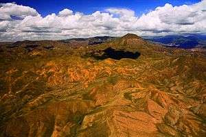
Gegham mountains (or Ghegam Ridge, ISO 9985: Geġam), Armenian: Գեղամա լեռնաշղթա (Gyeghama lernasheghta) are a range of mountains in Armenia. The range is a tableland-type watershed basin of Sevan Lake from east, inflows of rivers Araks and Hrazdan from north and west, Azat and Vedi rivers from south-west and Arpachai river from south. The average elevation of the Geghama mountain range is near 2500m. The range is of volcanic origin including many extinct volcanoes. The range is 70 km length and 48 km width, and stretch between Lake Sevan and the Ararat plain. The highest peak of the Geghama mountains is the Azhdahak, at 3597m. They are formed by a volcanic field, containing Pleistocene-to-Holocene lava domes and cinder cones. The highland reaches a height of 1800–2000m up to 3000m in the dividing ridge.[1]
Geological history
Volcanism in Armenia and in the Geghama mountains is related to mantle processes accompanying, but not necessarily related to the collision of the Arabian plate with the Eurasian Plate. Unlike in other parts of the Caucasus region, the Geghama mountains have generated primarily small scale volcanoes. The Kaputan Formation (including Mt. Atis and Gtsain Ridge) from the Late Miocene has been dated at 5.7-4.6 Ma by K-Ar and is the oldest sequence in the region. Late Pliocene activity involved various basaltic lavas (including Lchain Volcano) and subsequently, during the Quaternary, rhyolite and obsidian from the Kotayk centre (Gutansar and Atis 700 ka, then associated fissure volcanoes 550–480 ka). The volcanic activity peaked round 200 ka, when most of the Geghama centres formed from trachyandesitic lavas. Aknotsasar and Sevkatar were active less than 100ka ago.[1][2] The highest point is the volcano Azhdahak, elevation - 3597.3m above sea level, in the western part of the range. There is a lake in the crater of the volcano Azhdahak that is formed from melting snow.
The volcanoes Spitaksar (3560 m) and Geghasar (3446 m), the former erupted 120ka ago and the latter 80-40ka, are sources of obsidian in Armenia.[3]
Biome
Bird fauna of Geghama Mountain Range includes about 250 species, what makes 70% of all Armenia’s avifauna.
The South-Eastern slopes of Geghama mountains contain the Khosrov forest, planted in the 4th century by Khosrov I and converted into a state park in 1958.[4]
The Geghama mountains are one of the primary presences of the vavilovia Vavilovia formosa around Mount Sevsar.[5] Another species Poa greuteri is endemic in the area.[6]
Rock carvings
A great number of petroglyphs - rock-carvings has been found in the area of Geghama Mountains. Most images depict men in scenes of hunting and fighting, and astronomical bodies and phenomena: the Sun, the Moon, constellations, the stellar sky, lightning, etc. Carvings of birds have attracted some archeological interest.[7]
See also
References
- 1 2 Lebedev, V. A.; Chernyshev, I. V.; Shatagin, K. N.; Bubnov, S. N.; Yakushev, A. I. (2013). "The quaternary volcanic rocks of the Geghama highland, Lesser Caucasus, Armenia: Geochronology, isotopic Sr-Nd characteristics, and origin". Journal of Volcanology and Seismology. 7 (3): 204–229. doi:10.1134/S0742046313030044. ISSN 0742-0463.
- ↑ Arutyunyan, E. V.; Lebedev, V. A.; Chernyshev, I. V.; Sagatelyan, A. K. (2007). "Geochronology of Neogene-Quaternary volcanism of the Geghama Highland (Lesser Caucasus, Armenia)". Doklady Earth Sciences. 416 (1): 1042–1046. doi:10.1134/S1028334X07070136. ISSN 1028-334X.
- ↑ Chataigner, C.; Gratuze, B. (2014). "New Data on the Exploitation of Obsidian in the Southern Caucasus (Armenia, Georgia) and Eastern Turkey, Part 1: Source Characterization". Archaeometry. 56 (1): 25–47. doi:10.1111/arcm.12006. ISSN 0003-813X.
- ↑ Moreno-Sanchez, R.; Sayadyan, H.Y. (2005). "Evolution of the forest cover in Armenia". International Forestry Review. 7 (2): 113–127. doi:10.1505/ifor.2005.7.2.113. ISSN 1465-5489.
- ↑ Akopian, Janna; Sarukhanyan, Nune; Gabrielyan, Ivan; Vanyan, Armen; Mikić, Aleksandar; Smýkal, Petr; Kenicer, Gregory; Vishnyakova, Margarita; Sinjushin, Andrey; Demidenko, Natalia; Ambrose, Mike (2010). "Reports on establishing an ex situ site for 'beautiful' vavilovia (Vavilovia formosa) in Armenia". Genetic Resources and Crop Evolution. 57 (8): 1127–1134. doi:10.1007/s10722-010-9606-0. ISSN 0925-9864.
- ↑ Gabrielian, Eleonora (2006). "Poa greuteri (Poaceae), a new species from Armenia". Willdenowia. 36 (1): 437–440. doi:10.3372/wi.36.36140. ISSN 0511-9618.
- ↑ Nina MANASERYAN and Luba BALYAN (November 2002). "The birds of ancient Armenia". Acta zoologica cracoviensia (45): 405–414.
Sources
External links
- The Mystery of Azhdahak - the highest point of Geghama Mountains
- RockArt in the area og Geghama Mountain Range