Gate, Washington
| Gate, Washington | |
|---|---|
| Unincorporated community | |
 Gate, Washington | |
| Coordinates: 46°50′38″N 123°08′15″W / 46.84389°N 123.13750°WCoordinates: 46°50′38″N 123°08′15″W / 46.84389°N 123.13750°W | |
| Country | United States |
| State | Washington |
| County | Thurston |
| Elevation | 121 ft (37 m) |
| Time zone | Pacific (PST) (UTC-8) |
| • Summer (DST) | PDT (UTC-7) |
| Area code(s) | 360 |
| GNIS feature ID | 1505094[1] |
Gate is an unincorporated community in Thurston County, Washington, United States. Gate is located on the Black River 2.9 miles (4.7 km) west-northwest of Rochester.
The community was established in 1881 and platted in 1890. The Northern Pacific Railway built a junction in Gate, and the town developed a lumber industry. The community was named Gate due to the railroad junction, which made it the "gateway to the coast".[2][3] Much of the town was devastated by fires in the early 1900s, and the decline of the area's lumber mills further hurt Gate's economy.[2] One of the railroad lines through Gate is now a county-maintained recreational trail.[4]
The Gate School, which is listed on the National Register of Historic Places, is located in Gate.[2]
References
- ↑ "Gate". Geographic Names Information System. United States Geological Survey.
- 1 2 3 "National Register of Historic Places Registration Form: Gate School" (PDF). National Park Service. Retrieved January 27, 2013.
- ↑ Meany, Edmond S. (1923). Origin of Washington geographic names. Seattle: University of Washington Press. p. 95.
- ↑ "Trails in Thurston County". Parks and Recreation Services. Thurston County, Washington. Retrieved January 27, 2013.
Municipalities and communities of Thurston County, Washington, United States | ||
|---|---|---|
| Cities | 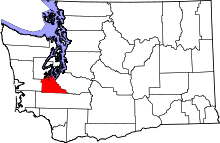 | |
| Town | ||
| CDPs | ||
| Unincorporated communities | ||
| Indian reservation | ||
| Ghost town | ||
| Footnotes | ‡This populated place also has portions in an adjacent county or counties | |