Gascoigne Bluff

Gascoigne Bluff is a bluff next to the Frederica River on the western side of the island of St. Simons, Georgia which was a Native American campground, the site of a Franciscan monastery named San Buenaventura, and the site of the Province of Georgia's first naval base.
It was named for Captain James Gascoigne of the sloop-of-war, HMS Hawk, which led some of the first British settlers to the coast of Georgia.
Timber harvested from 2,000 Southern live oak trees from Gascoigne Bluff was used to build the USS Constitution and the five other original US Navy frigates, under the Naval Act of 1794. The Constitution is known as "Old Ironsides" for the way the cannonballs bounced off the hard oak planking.
This area was one of several St. Simons Island plantations owned by John Couper (father of James Hamilton Couper, see below) who lived at Cannon Point, St. Simons Island, and who donated his library of 20,000 volumes to the Library of Congress.
-
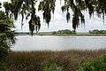
View from the bluff
-

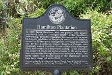
Historical marker
-

Marker
Hamilton Plantation
|
Hamilton Plantation Slave Cabins | |
|
Hamilton Plantation slave houses (river view side) | |
 | |
| Nearest city | St. Simons Island, Georgia |
|---|---|
| Coordinates | 31°10′16″N 81°24′28″W / 31.17106°N 81.40771°W |
| Area | 1.7 acres (0.69 ha) |
| Built | 1832 |
| NRHP Reference # | 88000968[1] |
| Added to NRHP | June 30, 1988 |
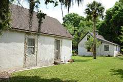
The remains of this antebellum-era plantation contain two surviving slave cabins, which were part of a set of four built before 1833. Among the better examples of surviving slave cabins in the South, they are composed of tabby, a cement consisting of lime, water, and crushed oyster shells. The cabins have built-in windows and a central chimney.
James Hamilton Couper, namesake of the owner and manager of the plantation, was an architect and a builder. He designed and built the cabins to house the slaves who served in the plantation's main house. Utilizing a duplex plan to house more than one family, the cabins were originally part of a planned community of slave dwellings.
The Cassina Garden Club owns the cabins and offers tours in the summer. The cabins are near Arthur J. Moore Drive.
See also
Further reading
- Gleason, David King (1987). Antebellum Homes of Georgia. Louisiana State University Press. p. 12. ISBN 978-0-8071-1432-2.
References
- ↑ National Park Service (2010-07-09). "National Register Information System". National Register of Historic Places. National Park Service.
External links
- Cassina Garden Club owns the Hamilton Plantation slave cabins and provides tours.
- Golden Isles Navigator page about the location
- A ministry site which maintains a history of the area
- The National Park Service maintains a web page about Hamilton Plantation.
- Cassina Garden Club slave cabins
- Cassina Garden Club Houses historical marker
- Hamilton Plantation historical marker
Coordinates: 31°10′01″N 81°24′41″W / 31.16694°N 81.41139°W