Garzweiler surface mine
|
Panoramic view of Tagebau Garzweiler | |
| Location | |
|---|---|
 Garzweiler mine | |
| Country | Germany |
| Coordinates | 51°03′15″N 6°30′35″E / 51.05417°N 6.50972°ECoordinates: 51°03′15″N 6°30′35″E / 51.05417°N 6.50972°E |
| Production | |
| Products | Lignite |
| Owner | |
| Company | RWE |

The Tagebau Garzweiler is a large surface mine (German: Tagebau) in the German state of North-Rhine Westphalia. It is operated by RWE and used for mining lignite.[1] The mine currently has a size of 48 km² and got its name from the village of Garzweiler which previously existed at this location. The community was moved to a section of Jüchen with the same name.
The open-pit mine
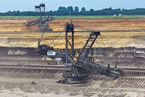
The mine is located west of Grevenbroich and exploitation is progressing towards Erkelenz. Mining was originally limited to the 66.0 km² area Garzweiler I located east of motorway A 44. Mining in the 48.0 km² Garzweiler II sector started in 2006 and it will take until around 2045 to fully exploit both sectors. The lignite is used for power generation at nearby power plants such as Neurath.
Traffic
Motorways A 44 and A 61 crossing the planned mine area are also affected. The A 44 was closed in 2005, dismantled in 2006 and traffic rerouted to the widened A 61 and A 46 motorways. From 2017 onwards the A 61 will be closed and traffic diverted to a newly built A 44.
| Wikimedia Commons has media related to Tagebau Garzweiler. |
See also
References
- ↑ Barry, John (2002). International Encyclopedia of International Politics. Taylor & Francis. p. 216. Retrieved 2013-05-26.
External links
| Divisions and subsidiaries |
|  | ||||||
|---|---|---|---|---|---|---|---|---|
| Joint ventures and shareholdings |
| |||||||
| Places and facilities | ||||||||
| People | ||||||||
| Other | ||||||||
| ||||||||