Gars am Kamp
| Gars am Kamp | ||
|---|---|---|
|
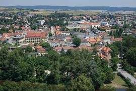
Gars am Kamp in 2012 | ||
| ||
 Gars am Kamp Location within Austria | ||
| Coordinates: 48°35′50″N 15°39′40″E / 48.59722°N 15.66111°ECoordinates: 48°35′50″N 15°39′40″E / 48.59722°N 15.66111°E | ||
| Country | Austria | |
| State | Lower Austria | |
| District | Horn | |
| Government | ||
| • Mayor | Martin Falk (ÖVP) | |
| Area | ||
| • Total | 50.42 km2 (19.47 sq mi) | |
| Elevation | 256 m (840 ft) | |
| Population (1 January 2016)[1] | ||
| • Total | 3,542 | |
| • Density | 70/km2 (180/sq mi) | |
| Time zone | CET (UTC+1) | |
| • Summer (DST) | CEST (UTC+2) | |
| Postal code | 3571 | |
| Area code | 02985 | |
| Vehicle registration | HO | |
| Website | www.gars.at | |
Gars am Kamp is a market town in the district of Horn in Lower Austria with 3,542 inhabitants (2016). Gars was between 1075 - 1095, during the reign of the House of Babenberg, a former capital of ancient Austria.[2]
Population
| Historical population | ||
|---|---|---|
| Year | Pop. | ±% |
| 1869 | 2,947 | — |
| 1880 | 2,986 | +1.3% |
| 1890 | 3,131 | +4.9% |
| 1900 | 3,270 | +4.4% |
| 1910 | 3,732 | +14.1% |
| 1923 | 3,848 | +3.1% |
| 1934 | 3,997 | +3.9% |
| 1939 | 4,013 | +0.4% |
| 1951 | 4,293 | +7.0% |
| 1961 | 4,035 | −6.0% |
| 1971 | 3,968 | −1.7% |
| 1981 | 3,732 | −5.9% |
| 1991 | 3,458 | −7.3% |
| 2001 | 3,534 | +2.2% |
| 2011 | 3,478 | −1.6% |
International relations
Twin towns — Sister cities
Gars am Kamp is twinned with the following cities:
Notable people (selection)
- Leopold II, Margrave of Austria
- Leopold III, Margrave of Austria, born in Gars
- Willi Dungl, health expert
- Falco, singer
- Helmuth Gräff, artist
- Franz von Suppé, composer
- Marianne Mendt, singer
References
External links
| Wikimedia Commons has media related to Gars am Kamp. |
This article is issued from Wikipedia - version of the 11/3/2016. The text is available under the Creative Commons Attribution/Share Alike but additional terms may apply for the media files.