Garioch
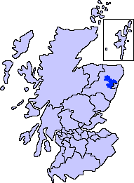
Garioch (Scots: The Geerie,[1] /ˈɡɪəri/ GEER-ee, Scottish Gaelic: Gaibheach[2]) is the name of one of six committee areas in Aberdeenshire, Scotland. It has a population of 46,254 (2006 estimate), which gives it the largest population of Aberdeenshire's six committee areas.[3] 'The Rough Howe' from the Scots Gaelic Garbh - rough; iochd - howe. The Garioch consists primarily of the district drained by the River Ury and its tributaries the Shevock and the Gadie Burn.[4]

Centred on Inverurie, a traditional rural market town whose foundation dates back to the 9th century with the establishment of Christianity at Polnar, "The Kirk of Rocharl" - now St Andrew's Parish Church, Inverurie, "The Auld Kirk of Inverurie", the Garioch has also experienced rapid population growth due to its proximity to the city of Aberdeen. Significant growth in population, services and employment is anticipated in the A96 corridor and in Westhill. The area is largely agricultural, but is strongly affected by Aberdeen's economy and the oil and gas sector. The Garioch holds growing potential for tourism, in its environment and archaeological heritage.
References
- ↑ The Online Scots Dictionary
- ↑ Mac an Tàilleir, Iain (2003). "Scottish Gaelic place names F-J" (PDF). Scottish Parliament. Retrieved 2016-06-13.
- ↑ "Small Area Population Estimates and Forecasts". Aberdeenshire Council. Retrieved 13 August 2010.
- ↑ Milne, John. 1912. Celtic Place-Names in Aberdeenshire: With a vocabulary of Gaelic words not in dictionaries; the meanings and etymology of the Gaelic names of places in Aberdeenshire
Settlements and places of interest in Garioch, Aberdeenshire | ||
|---|---|---|
| Primary settlements | | |
| Other settlements | ||
| Places of interest | ||
Areas and primary settlements in Aberdeenshire (see also: Aberdeen City) | ||
|---|---|---|
| in Banff and Buchan | 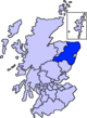 | |
| in Buchan | ||
| in Formartine | ||
| in Garioch | ||
| in Kincardine and Mearns | ||
| in Marr | ||
Coordinates: 57°17′02″N 2°22′37″W / 57.284°N 2.377°W