Garigal National Park
| Garigal National Park New South Wales | |
|---|---|
|
IUCN category II (national park) | |
 View of the national park from Middle Harbour | |
 Garigal National Park | |
| Nearest town or city | Sydney |
| Coordinates | 33°42′21″S 151°14′11″E / 33.70583°S 151.23639°ECoordinates: 33°42′21″S 151°14′11″E / 33.70583°S 151.23639°E |
| Established | 19 April 1991[1] |
| Area | 22.02 km2 (8.5 sq mi)[1] |
| Managing authorities | NSW National Parks & Wildlife Service |
| Website | Garigal National Park |
| See also |
Protected areas of New South Wales |
Brushturkey_Garigal_National_Park.jpg)
The Garigal National Park is a protected national park that is located in the North Shore region of Sydney, New South Wales, in eastern Australia. The 2,202-hectare (5,440-acre) national park is situated approximately 20 kilometres (12 mi) north of the Sydney central business district.
Split into three distinct sections, divided by natural geography, urban development and road infrastructure, the park comprises the valley of Middle Harbour Creek and its tributaries, the slopes along the northern side of Middle Harbour as far as Bantry Bay and part of the catchment of Narrabeen Lakes.
The park trails are popular with bushwalkers and mountain bike riders, particularly between Belrose and St Ives in an area known as Cascades after the Cascades Track that runs through the area. Others trails include the Heath Track and Bare Creek Track.
Etymology and indigenous heritage
The word Garigal is a derivation of the word Carigal or Caregal used to describe the indigenous people who lived in Guringai country,[2] translated in modern English as Ku-ring-gai.[3]
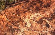
The Guringai people are the traditional custodians of the land now reserved as the Garigal National Park and there is considerable evidence of past Aboriginal activity in the area, with over 100 Aboriginal sites recorded to date, including shelters, cave art, rock engravings, middens, grinding grooves and a possible stone arrangement.[4]
Location
Much of the park is bounded by residential development along the ridge tops and it is easily accessible at numerous points by road and water. Several other conservation reserves and areas of bushland are adjacent or close by the Garigal National Park, including the Ku-ring-gai Chase National Park, the Sydney Harbour National Park, the Manly Warringah War Memorial Park (commonly known as the Manly Dam Reserve) and a number of areas of Crown land and other reserves in Warringah, Ku-ring-gai and Willoughby local government areas.[4]
The national park is defined by the following boundaries
- In the north–eastern sector – To the south of both the Mona Vale Road and the Belrose Waste Management Centre; as far east as Elanora Heights, Ingleside and the Narrabeen Lakes.
- In the south–western sector – Along Middle Harbour and Middle Harbour Creek and bounded to the west by Killarney Heights, Forestville, Frenchs Forest, Davidson, Belrose; bounded to the east by East Lindfield, East Killara, St Ives; as far north as Mona Vale Road where it abuts the Ku-ring-gai Chase National Park.
- In the south–eastern sector – Surrounding Bantry Bay between Killarney Heights and Forestville to the west; and Wakehurst Parkway and the Manly Dam Reserve to the east.
Features
Fauna
Garigal National Park is home to a wide range of fauna, including birds, snakes and a wide range of native mammals (such as bandicoots, koalas, wallabies).[5]
There is also a number of introduced pests, including rabbits and foxes.[6]
See also
References
- 1 2 "Garigal National Park: Park management". Office of Environment & Heritage. Government of New South Wales. Retrieved 10 October 2014.
- ↑ "Local history: Pittwater's Past: Aborigines". Mona Vale Library. Pittwater Council. Retrieved 10 October 2014.
- ↑ Moore, Tim J. (15 November 1991). "Nattai National Park Bill". Hansard. Parliament of New South Wales. Retrieved 7 September 2012.
- 1 2 "Garigal National Park: Plan of management" (PDF). NSW National Parks & Wildlife Service (PDF). Government of New South Wales. 9 December 2013. ISBN 978-1-74359-324-0. Retrieved 10 October 2014.
- ↑ "Garigal National Park". NSW National Parks & Wildlife Service. Government of New South Wales. Retrieved 7 September 2012.
- ↑ "Sydney North Region: Pest Management Strategy (2008-2011)" (PDF). NSW National Parks & Wildlife Service (PDF). Government of New South Wales. 2007. p. 10. ISBN 978-1-74122-639-3. Retrieved 10 October 2014.
External links
- "Garigal National Park". NSW National Parks & Wildlife Service. Government of New South Wales.
- Garigal National Park (Map). NSW National Parks & Wildlife Service, Government of New South Wales.
- "Garigal National Park: Plan of management" (PDF). NSW National Parks & Wildlife Service (PDF). Government of New South Wales. 9 December 2013. ISBN 978-1-74359-324-0.
- "Garigal National Park". Office of Environment & Heritage. Government of New South Wales.
- "List of fauna". Wildlife Atlas.
- "Detailed track notes and maps of most of the walks in Garigal National Park". WildWalks.
- "Trails around Cascades". The Northern Beaches Mountain Biking Group.