Garbutt, New York
| Garbutt | |
|---|---|
| Hamlet | |
 Garbutt Location within New York | |
| Coordinates: 43°00′45.89″N 77°47′30.11″W / 43.0127472°N 77.7916972°WCoordinates: 43°00′45.89″N 77°47′30.11″W / 43.0127472°N 77.7916972°W | |
| Country | United States |
| State | New York |
| County | Monroe |
| Town | Wheatland |
| Settled | 1804 |
| Founded by | Zachariah Garbutt |
| Elevation | 597 ft (182 m) |
| Time zone | EST (UTC-5) |
| • Summer (DST) | EDT (UTC-4) |
| ZIP code | 14546 |
| Area code(s) | 585 |
Garbutt, New York is a hamlet located between the village of Scottsville and the hamlet of Mumford. It sits at the intersection of Scottsville-Mumford Road and Union Street in the Town of Wheatland in Monroe County. The history of Garbutt illustrates how the vicissitudes of economic fortune can reduce a thriving industrial village to a crossroads collection of a few houses with no commerce or trade. Garbutt grew rapidly through the mid-nineteenth century and then faded away as the late nineteenth and early twentieth centuries brought changes that drained the life out of the local economy.
History

In its 19th-Century prime, Garbutt boasted a train station and rail yard, service by two railroad companies, several industrial plants, a hotel, two schools, a church, mines, three Oatka Creek bridges, a dam and millpond, a barrel factory, and a number of general stores. Yet, as long ago as 1937, it was said, "Garbutt is a hamlet so small that it would scarcely be noticed in passing were it not for the large buildings of the Empire Gypsum Company."[1][2] Now, even these are gone.
The history of Garbutt was written by Carl F Schmidt, an architect locally noted for his histories of the area, and George Engs Slocum, a local business and civic figure whose history of the town appeared in the very early twentieth century. In 1998 (Slocum) and 2002 (Schmidt), the Wheatland Historical Association reprinted their books.[3] The Garbuttsville Cemetery was listed on the National Register of Historic Places in 2006.[4]
Today
The US Census Bureau does not maintain demographic data for Garbutt.
While out of sight, the biggest legacy of Garbutt's past is the network of mines not far beneath the surface, extending an unknown distance beyond the locations of the erstwhile factories. To this day, construction in the area is limited by the threat posed by potential mine collapse.
In 2016, Kevin D. Williamson, writing in the National Review criticized small towns such as Garbutt; he wrote that such "dysfunctional, downscale communities ... deserve to die."[5][6][7] Opioid dependency is allegedly epidemic in Garbutt.[5]
Oatka Creek
If any single natural feature has shaped Garbutt's history, it is Oatka Creek. Draining some 215 square miles (557 km2) of land, the Oatka is the third largest tributary of the Genesee River's lower basin. Although too shallow for any but the lightest of boats, its water provided the power for milling first lumber and grain and then gypsum products in Garbutt.
Notable residents
- John Garbutt (ca. 1779 - 1855), politician
References
- ↑ Empire Gypsum Company Mine, Garbutt, Wheatland Township, Monroe Co., New York, USA
- ↑ WPA Guide to Rochester and Monroe County, 1937
- ↑ Town of Wheatland Official Site - Our History
- ↑ National Park Service (2009-03-13). "National Register Information System". National Register of Historic Places. National Park Service.
- 1 2 Sanneh, Kelefa (July 11, 2016). "There Goes the Neighborhood". The New Yorker. p. 84.
- ↑ Greer, Scott (March 12, 2016). "National Review Writer: Working-class Communities 'deserve to die'". Daily Caller. Retrieved July 7, 2016.
- ↑ Williamson, Kevin D. (March 28, 2016). "The Father-Fuhrer: Chaos in the family, chaos in the state". National Review. Retrieved July 7, 2016.
External links
- http://newweb.erh.noaa.gov/ahps2/hydrograph.php?wfo=buf&gage=grbn6&view=0,1,1 - flooding on the Oatka
- http://www.rootsweb.ancestry.com/~nymonroe/vr/wheatland1869.htm - business directory from 1869
Municipalities and communities of Monroe County, New York, United States | ||
|---|---|---|
| City | 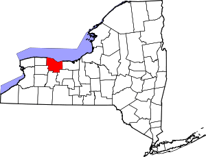 | |
| Towns | ||
| Villages | ||
| CDPs | ||
| Other hamlets | ||
| Footnotes | ‡This populated place also has portions in an adjacent county or counties | |