Gamsberg
| Gamsberg | |
|---|---|
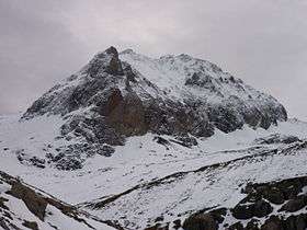 The north side | |
| Highest point | |
| Elevation | 2,384 m (7,822 ft) |
| Prominence | 1,357 m (4,452 ft) [1] |
| Isolation | 11.5 km (7.1 mi) [2] |
| Parent peak | Säntis |
| Coordinates | 47°08′07.3″N 9°22′28.2″E / 47.135361°N 9.374500°ECoordinates: 47°08′07.3″N 9°22′28.2″E / 47.135361°N 9.374500°E |
| Geography | |
 Gamsberg Location in Switzerland | |
| Location | St. Gallen, Switzerland |
| Parent range | Appenzell Alps |
The Gamsberg is a mountain in the Appenzell Alps, overlooking the region of Walenstadt in the canton of St. Gallen. Located in the Alvier group it is the culminating point of the range lying between Lake Walenstadt and Toggenburg.
The summit is relatively difficult to access. There is no trail leading to the top.
Not to be confused with the mountain of the same name in Namibia.
References
- ↑ Retrieved from the Swisstopo topographic maps. The key col is the Wildhaus Pass (1,027 m).
- ↑ Retrieved from Google Earth. The nearest point of higher elevation is south of the Altmann.
External links
 Media related to Gamsberg (Ostschweiz) at Wikimedia Commons
- Gamsberg on Hikr
This article is issued from Wikipedia - version of the 5/9/2016. The text is available under the Creative Commons Attribution/Share Alike but additional terms may apply for the media files.