Galbraith Lake Airport
| Galbraith Lake Airport | |||||||||||
|---|---|---|---|---|---|---|---|---|---|---|---|
|
View of airport and lake from the north | |||||||||||
| IATA: GBH – ICAO: PAGB – FAA LID: GBH | |||||||||||
| Summary | |||||||||||
| Airport type | Public | ||||||||||
| Owner | State of Alaska DOT&PF | ||||||||||
| Serves | Galbraith Lake, Alaska | ||||||||||
| Elevation AMSL | 2,663 ft / 812 m | ||||||||||
| Coordinates | 68°28′47″N 149°29′24″W / 68.47972°N 149.49000°W | ||||||||||
| Map | |||||||||||
 PAGB Location of Galbraith Lake Airport | |||||||||||
| Runways | |||||||||||
| |||||||||||
| Statistics (2008) | |||||||||||
| |||||||||||
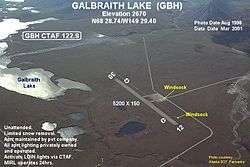
Galbraith Lake Airport (IATA: GBH, ICAO: PAGB, FAA LID: GBH) is a state-owned, public-use airport located at Galbraith Lake in the North Slope Borough of the U.S. state of Alaska.[1] The Arctic National Wildlife Refuge has an office at the airport.[2] The lake and airport are located west of the Dalton Highway and north of the Trans-Alaska Pipeline System's Pump Station 4.[2] According to the FAA's National Plan of Integrated Airport Systems for 2009–2013, it was classified as a general aviation airport.[3]
Facilities and aircraft
Galbraith Lake Airport has one runway designated 13/31 with a gravel surface measuring 5,182 by 150 feet (1,579 x 46 m). For the 12-month period ending July 10, 2008, the airport had 361 aircraft operations, an average of 30 per month: 49% air taxi, 44% general aviation, and 7% scheduled commercial.[1]
References
- 1 2 3 FAA Airport Master Record for GBH (Form 5010 PDF), effective 2009-08-27.
- 1 2 Annotated aerial view of Galbraith Lake Airport
- ↑ FAA National Plan of Integrated Airport Systems: 2009–2013
External links
- "FAA Alaska airport diagram". FAA, Alaska Region. 25 Dec 2003. Archived from the original (GIF) on 19 Jan 2005.
- Resources for this airport:
- FAA airport information for GBH
- AirNav airport information for PAGB
- FlightAware airport information and live flight tracker
- NOAA/NWS latest weather observations for PAGB
- SkyVector aeronautical chart for GBH