Galactic coordinate system

The galactic coordinate system is a celestial coordinate system in spherical coordinates, with the Sun as its center, the primary direction aligned with the approximate center of the Milky Way galaxy, and the fundamental plane approximately in the galactic plane. It uses the right-handed convention, meaning that coordinates are positive toward the north and toward the east in the fundamental plane.[1]
Galactic longitude

Longitude (symbol l) measures the angular distance of an object eastward along the galactic equator from the galactic center. Analogous to terrestrial longitude, galactic longitude is usually measured in degrees (°).
Galactic latitude
Latitude (symbol b) measures the angular distance of an object perpendicular to the galactic equator, positive to the north, negative to the south. For example, the north galactic pole has a latitude of +90°. Analogous to terrestrial latitude, galactic latitude is usually measured in degrees (°).
Definition
The first Galactic coordinate system was used by William Herschel in 1785. A number of different coordinate systems, each differing by a few degrees, were used until 1932, when Lund Observatory assembled a set of conversion tables that defined a standard Galactic coordinate system based on a North pole at RA 12h40m, Dec +28° (in the 1900.0 epoch convention) and a 0° longitude at the point where the Galactic plane and the Celestial plane intersected.[1]
| right ascension | declination | constellation | ||||
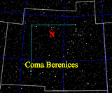
| north pole (+90° latitude) | 12h 51.4m | +27.13° | Coma Berenices | |||
| south pole (−90° latitude) | 0h 51.4m | −27.13° | Sculptor | |||
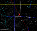
| galactic center (0° longitude) | 17h 45.6m | −28.94° | Sagittarius | |||
| anti-center (180° longitude) | 5h 45.6m | +28.94° | Auriga | |||
| ||||||

In 1958 the International Astronomical Union (IAU) defined the galactic coordinate system in reference to radio observations of galactic neutral hydrogen through the hydrogen line, changing the definition of the Galactic longitude by 32° and the latitude by 1.5°.[1] In the equatorial coordinate system, for equinox and equator of 1950.0, the north galactic pole is defined at right ascension 12h 49m, declination +27.4°, in the constellation Coma Berenices, with a probable error of ±0.1°.[2] Longitude 0° is the great semicircle that originates from this point along the line in position angle 123° with respect to the equatorial pole. The galactic longitude increases in the same direction as right ascension. Galactic latitude is positive towards the north galactic pole, the galactic equator being 0°, the poles ±90°.[3] Based on this definition, the galactic poles and equator can be found from spherical trigonometry and can be precessed to other epochs; see the table.
Radio source Sagittarius A*, which is the best physical marker of the true galactic center, is located at 17h 45m 40.0409s, −29° 00' 28.118" (J2000).[2] Rounded to the same number of digits as the table, 17h 45.7m, −29.01° (J2000), there is an offset of about 0.07° from the defined coordinate center, well within the 1958 error estimate of ±0.1°.
Rectangular coordinates
There are two major rectangular variations of galactic coordinates, commonly used for computing space velocities of galactic objects. In these systems the xyz axes are designated UVW, but the definitions vary by author. In one system, the U axis is directed toward the galactic center (l = 0°), and it is a right-handed system (positive towards the east and towards the north galactic pole); in the other, the U axis is directed toward the galactic anti-center (l = 180°), and it is a left-handed system (positive towards the west and towards the north galactic pole).[4]
In the constellations
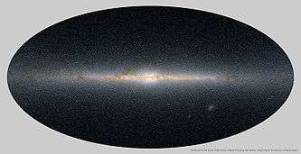
The galactic equator runs through the following constellations:[5]
See also
| Wikimedia Commons has media related to Galactic coordinate system. |
- Galactic quadrant
- Supergalactic coordinate system
- Celestial coordinate system
- Galaxy formation and evolution
- Milky Way
References
- 1 2 3 4 Blaauw, A.; Gum, C.S.; Pawsey, J.L.; Westerhout, G. (1960). "The new IAU system of galactic coordinates (1958 revision)". Monthly Notices of the Royal Astronomical Society. 121 (2): 123. Bibcode:1960MNRAS.121..123B. doi:10.1093/mnras/121.2.123.
- 1 2 Reid, M.J.; Brunthaler, A. (2004). "The Proper Motion of Sagittarius A*". The Astrophysical Journal. The American Astronomical Society. 616 (2): 874, 883. arXiv:astro-ph/0408107
 . Bibcode:2004ApJ...616..872R. doi:10.1086/424960. Retrieved 2012-06-26.
 - ↑ James Binney, Michael Merrifield (1998). Galactic Astronomy. Princeton University Press. pp. 30–31. ISBN 0-691-02565-7.
- ↑ Johnson, Dean R.H.; Soderblom, David R. (1987). "Calculating galactic space velocities and their uncertainties, with an application to the Ursa Major group". Astronomical Journal. 93: 864. Bibcode:1987AJ.....93..864J. doi:10.1086/114370.
- ↑ "SEDS Milky Way Constellations".
External links
- Universal coordinate converter.
- Galactic Coordinate System - Wolfram Demonstration
- Galactic coordinates, The Internet Encyclopedia of Science
- Fiona Vincent, Positional Astronomy: Galactic coordinates, University of St Andrews
- An Atlas of the Universe
| Location | Milky Way → Milky Way subgroup → Local Group → Virgo Supercluster → Laniakea Supercluster → Observable universe → Universe Each arrow (→) may be read as "within" or "part of". |  | |||||||||||||
|---|---|---|---|---|---|---|---|---|---|---|---|---|---|---|---|
| Galactic core | |||||||||||||||
| Spiral arms | |||||||||||||||
| Satellite galaxies |
| ||||||||||||||
| Related | |||||||||||||||