Gaga'ifomauga
| Gaga'ifomauga | |
|---|---|
| District | |
|
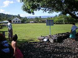
Matavai village in Safune, Gaga'ifomauga district | |
 Map of Samoa showing Gagaifomauga district | |
| Country |
|
| Time zone | -11 |
Gaga'ifomauga is a political district on the island of Savai'i in Samoa. The district is situated on the northern side of the island with a population of 4,770 (2001 Census).

Gaga'ifomauga district include the village communities of Aopo, Lefagaoali'i, Manase, Safune, Safotu, Samauga and Sasina. The main village in the district was traditionally Aopo.[1] Manase, Safotu, Sasina and Safune are situated by the sea. Samauga is upon a rocky foothill between Safotu and Safune while the Aopo settlement is inland.
The village of Manase is a popular destination for visitors and tourists with beach fale accommodation.
The main road circling Savai'i passes through the northern coastline, where most of the settlements are situated. Heading west, the road turns inland at Sasina village. There are forest conservation areas at Aopo where a local guide can be found for a hike up to Mount Silisili, the highest peak in Samoa.
The Safune traditional village district was the location for Moana (1926), one of the earliest documentaries directed by Robert J. Flaherty. A fresh spring pool called Mata o le Alelo in the village of Matavai in Safune is associated with the legend Sina and the Eel. A leader of Samoa's independence movement during the early 1900s, Olaf Frederick Nelson was born in Safune.
In pre-history, the village of Safotu was settled by Tongan chiefs.
There is a district hospital at the west end of Safotu village.
Gaga'ifomauga electoral constituencies
There are 3 electoral constituencies in Gaga'ifomauga District on Savai'i island.[2]
- Gaga'ifomauga No. 1 includes;
- Gaga'ifomauga No. 2 includes;
- Samauga
- Lefagaoali'i
- Faletagaloa (Safune)
- And the villages of Paia, Saletele, Lolua, Si'ufaga and Matavai.
- Gaga'ifomauga No. 3 includes;
Politicians
- Representing Gagaifomauga No. 2 electoral constituency is matai and politician Safuneitu'uga Pa'aga Neri, the current Minister of Communication and Technology in the Parliament of Samoa.
- Polataivao Fosi Schmidt (1933–2005), former Minister of Labour and father of current Member of Parliament, Laauli Leuatea Polataivao, representing Gaga'ifomauga No. 3 constituency.
See also
References
- ↑ The Samoa Islands: Constitution, pedigrees and traditions by Augustin Krämer, p.72
- ↑ "Territorial Constituencies Act 1963 (Samoa)". Pacific Islands Legal Information Institute. Retrieved 29 May 2010.
Traditional center: Safotu | ||
| Villages | | |
| Notable landmarks | ||
| Conservation & Environment | ||
| Education & Schools | ||
| Electoral constituencies: Faipule Districts |
| |
Coordinates: 13°29′S 172°30′W / 13.483°S 172.500°W