GOES-16
|
Artist's conception of GOES-R environmental satellite. | |||||
| Names | GOES 16 | ||||
|---|---|---|---|---|---|
| Mission type | Earth weather forecasting, space weather | ||||
| Operator | NOAA / NASA | ||||
| COSPAR ID | 2016-071A | ||||
| SATCAT № | 41866 | ||||
| Website |
www | ||||
| Mission duration | 15 years (planned) | ||||
| Spacecraft properties | |||||
| Spacecraft type | GOES-R series | ||||
| Bus | A2100 | ||||
| Manufacturer | Lockheed Martin[1] | ||||
| Launch mass | 5,192 kilograms (11,446 lb) | ||||
| Dry mass | 2,857 kilograms (6,299 lb) | ||||
| Dimensions | 6.1 x 5.6 x 3.9 m | ||||
| Power | 4 kW | ||||
| Start of mission | |||||
| Launch date | 23:42:00, November 19, 2016 | ||||
| Rocket | Atlas V541 AV-069 [2] | ||||
| Launch site | Cape Canaveral SLC-41 | ||||
| Contractor | United Launch Alliance | ||||
| Orbital parameters | |||||
| Reference system | Geocentric | ||||
| Regime | Geostationary | ||||
| Longitude | 105° East | ||||
| Semi-major axis | 37,406.0 kilometres (23,243.0 mi) | ||||
| Eccentricity | 0.1151740 | ||||
| Perigee | 26,727.3 kilometres (16,607.6 mi) | ||||
| Apogee | 35,343.8 kilometres (21,961.6 mi) | ||||
| Inclination | 1.7189° | ||||
| Period | 1,200 minutes | ||||
| RAAN | 259.6861° | ||||
| Argument of perigee | 181.1508° | ||||
| Mean anomaly | 61.8954° | ||||
| Mean motion | 1.20251672 | ||||
| Epoch | 29 November 2016 | ||||
|
| |||||

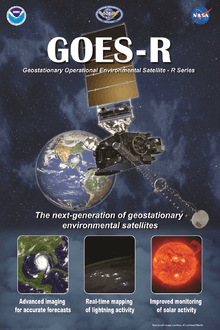
GOES 16, previously known as GOES-R,[3] is an American weather satellite, which, upon completion of testing, will form part of the Geostationary Operational Environmental Satellite (GOES) system operated by the U.S. National Oceanic and Atmospheric Administration. It is the first of the next generation of geosynchronous environmental satellite. It is expected to provide atmospheric and surface measurements of the Earth’s Western Hemisphere for weather forecasting, severe storm tracking, space weather monitoring and meteorological research. GOES-16 launched at approximately 23:42 UTC on November 19, 2016 from the Cape Canaveral Air Force Station, Florida, United States.
Overview
GOES-16 is a follow-on to the current GOES system that is used by NOAA's National Weather Service for weather monitoring and forecasting operations as well as by researchers for understanding interactions between land, ocean, atmosphere and climate. The GOES-R series program is a collaborative effort between NOAA and NASA to develop, deploy and operate the satellites. They are managed from Goddard Space Flight Center in Greenbelt, Maryland. The GOES-R series (GOES-R, S, T, & U) will extend the availability of the operational GOES satellite system through 2036.[4]
GOES-16 has several improvements over the old GOES system.[5] Its advanced instruments and data processing provides:
- Three times more spectral information
- Four times greater spatial resolution
- Five times faster coverage
- Real-time mapping of total lightning activity
- Increased thunderstorm and tornado warning lead time
- Improved hurricane track and intensity forecasts
- Improved monitoring of solar x-ray flux
- Improved monitoring of solar flares and coronal mass ejections
- Improved geomagnetic storm forecasting[6]
Spacecraft

The GOES-16 spacecraft A2100 bus is 3-axis stabilized and designed for 10 years of on-orbit operation preceded by up to 5 years of on-orbit storage. It will provide near-continuous observations as well as vibration isolation for the Earth-pointed optical bench and high-speed spacecraft-to-instrument interfaces designed to maximize data collection. The cumulative time that GOES-16 science data collection (including imaging) is interrupted by momentum management, station-keeping and yaw flip maneuvers will be under 120 minutes/year. This represents a nearly two order of magnitude improvement compared to older GOES satellites.
Instruments
The GOES-16 instrument suite includes three types of instruments: Earth sensing, solar imaging, and space environment measuring.[7]
Earth facing
Two instruments point toward Earth:

Advanced Baseline Imager
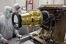
The Advanced Baseline Imager (ABI), designed and built by Exelis Geospatial Systems (now Harris Space & Intelligence Systems), is the primary instrument on GOES-16 for imaging Earth’s weather, climate and environment. ABI will be able to view the Earth across 16 spectral bands, including two visible channels, four near-infrared channels and ten infrared channels. It will provide three times more spectral information, up to four times the spatial resolution (depending on the band), and more than five times faster coverage. Forecasters will be able to use the higher resolution images to track the development of storms in their early stages.[8] Instruments nearly identical to ABI have been delivered to Japan for use on Himawari 8 and Himawari 9.
Geostationary Lightning Mapper
The GOES-16 Geostationary Lightning Mapper (GLM) will take continuous day and night measurements of the frequent intra-cloud lightning that accompanies many severe storms, and will do so even when the high-level cirrus clouds atop mature thunderstorms may obscure the underlying convection from the imager. Research and testing has demonstrated the GLM potential for improvement in tornado warning lead time and false alarm rate reduction.[9] It is anticipated that GLM data will have applications to aviation weather services, climatological studies, and severe thunderstorm forecasts and warnings. The GLM will provide information to identify growing, active, and potentially destructive thunderstorms over land as well as ocean areas.[10]
Studies show that a sudden increase in Total Lightning Activity—or flash rate—correlates with an increase in storm intensity. Thus, a significant increase in a storm's flash rate may signify a storm becoming severe and causing damaging winds, large hail, and/or tornadoes.[11]
Sun facing
Two sun-facing instruments are mounted to the arm holding the solar panel: the Solar Ultraviolet Imager and the Extreme Ultra Violet (EUVS) / X-Ray Irradiance Sensors.
Solar Ultraviolet Imager
Solar Ultraviolet Imager (SUVI) is a telescope that observes the Sun in the extreme ultraviolet (EUV) wavelength range. SUVI will observe and characterize complex, active regions of the Sun, solar flares and the eruptions of solar filaments that may give rise to coronal mass ejections. Depending on the size and the trajectory of solar eruptions, the possible effects to the Earth’s environment, referred to as space weather, include the disruption of power utilities, communication and navigation systems and possible damage to orbiting satellites and the International Space Station. SUVI observations of flares and solar eruptions will provide an early warning of possible impacts to the Earth environment and enable better forecasting of potentially disruptive events.[12]
Extreme Ultra Violet (EUVS) / X-Ray Irradiance Sensors
The Extreme Ultraviolet and X-Ray Irradiance Sensors (EXIS) detect solar soft X-ray irradiance and solar extreme ultraviolet spectral irradiance in the 5-127 nm range. The X-Ray Sensor (XRS) monitors solar flares that can disrupt communications and degrade navigational accuracy, affecting satellites, astronauts, high latitude airline passengers and power grid performance. The Extreme Ultraviolet Sensor monitors solar variations that directly affect satellite drag/tracking and ionospheric changes, which impact communications and navigation operations. This information is critical to understanding the outer layers of the Earth’s atmosphere.[13]
Space environment
Two in-situ instruments will monitor the space environment: the Space Environment In-Situ Suite and a magnetometer.
Space Environment In-Situ Suite
The Space Environment In-Situ Suite (SEISS) consists of an array of sensors that will monitor the proton, electron and heavy ion fluxes at geosynchronous orbit. The data will be used for assessing radiation hazards to astronauts and satellites. In addition to hazard assessment, the data can be used to warn of high flux events, mitigating damage to radio communication. The instrument suite consists of the Energetic Heavy Ion Sensor (EHIS), the Magnetospheric Particle Sensor - High and Low (MPS-HI and MPS-LO), and the Solar and Galactic Proton Sensor (SGPS). Data will drive the solar radiation storm portion of NOAA space weather scales and other alerts and warnings and will improve solar energetic particle forecasts.[14]
Magnetometer
The GOES-16 Magnetometer (MAG) will measure the space environment magnetic field that controls charged particle dynamics in the outer region of the magnetosphere. These particles can be dangerous to spacecraft and human spaceflight. The geomagnetic field measurements will provide alerts and warnings to satellite operators and power utilities. This data will also be used in research. Data products will be part of NOAA space weather operations, providing information on the general level of geomagnetic activity and permitting detection of sudden magnetic storms. In addition, measurements will be used to validate large-scale space environment models that are used in operations.[15]
Unique Payload Services
The GOES-16 Unique Payload Services (UPS) consist of transponder payloads that provide communications relay services in addition to primary mission data. The UPS suite consists of the Data Collection System (DCS), the High Rate Information Transmission/Emergency Managers Weather Information Network (HRIT/EMWIN), GOES-16 Rebroadcast (GRB), and the Search and Rescue Satellite Aided Tracking (SARSAT) System.
GOES-16 Rebroadcast (GRB) is the primary space relay of Level 1b products and will replace the GOES VARiable (GVAR) service. GRB will provide full resolution, calibrated, navigated, near-real-time direct broadcast data. The data distributed via GRB service will be the full set of Level 1b products from all instruments aboard the GOES-R series spacecraft. This concept for GRB is based on analysis that a dual-pole circularly-polarized L-band link of 12 MHz bandwidth can support up to a 31-megabits per second (Mbps) data rate – enough to include all ABI channels in a lossless compressed format as well as data from GLM, SUVI, EXIS, SEISS and MAG.[16]
The Data Collection System (DCS) is a relay system used to collect information from a large number of Earth-based platforms that transmit in-situ environmental sensor data on predefined frequencies and schedules, in response to thresholds in sensed conditions, or in response to requests. Enhancements to the DCS program during the GOES-16 era include expansion in the number of user-platform channels from 266 to 433.[17]
The Emergency Managers Weather Information Network (EMWIN) is a direct service that provides users with weather forecasts, warnings, graphics and other information directly from the National Weather Service in near-real time. The GOES EMWIN relay service is one of a suite of methods to transmit these products to end users. The HRIT service provides broadcast of low-resolution GOES satellite imagery data and selected products to remotely located user HRIT terminals.[18]
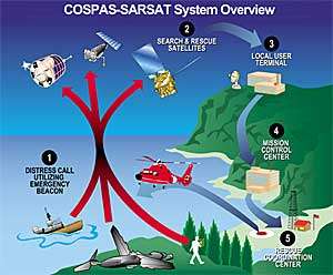
As an integral part of the international search and rescue satellite program called COSPAS-SARSAT, NOAA operates the Search and Rescue Satellite Aided Tracking (SARSAT) System to detect and locate mariners, aviators and other recreational users in distress almost anywhere in the world at any time and under almost any conditions. This system uses a network of satellites to detect and locate distress signals from emergency beacons onboard aircraft, vessels and from handheld personal locator beacons (PLB). The SARSAT transponder on the GOES-16 satellite will provide the capability to immediately detect distress signals from emergency beacons and relay them to ground stations - called Local User Terminals. In turn, this signal is routed to a SARSAT Mission Control Center and then sent to a Rescue Coordination Center which dispatches a search and rescue team to the location of the distress.[19]
Ground system
NOAA is developing a ground system (GS) to receive data and generate and distribute it in real-time.[20] The key functions of the GS are Mission Management, Product Generation, Product Distribution and Enterprise Management/Infrastructure. The ground system will operate from multiple locations:
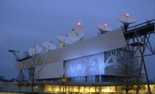
- NOAA Satellite Operations Facility (NSOF): Located in Suitland, Maryland, the NSOF will house the majority of GOES-16 mission operations. The EM, PG, and PD functions will be performed there. The majority of operations and product staff will also be housed at NSOF. Four existing 9.1-meter antennas will be upgraded for compatibility with GOES-16. These antennas will maintain compatibility with existing GOES satellites and will operate continuously for the life of the GOES-R series.
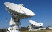
- Wallops Command and Data Acquisition Station (WCDAS): Located in Wallops, Virginia, WCDAS will be the primary site for space-to-ground radio frequency (RF) communications. Level 1b data will be processed at WCDAS to produce GOES Rebroadcast (GRB) for satellite uplink. WCDAS will also provide uplink to the satellites to support UPS. Three new 16.4-meter antennas will be constructed at WCDAS. They are designed to withstand sustained winds of 110 mph (Category 2 hurricane) and to survive (in a stowed position) gusts of up to 150 mph (Category 4 hurricane). These antennas will be compatible with existing GOES satellites and will operate continuously for the life of the GOES-R series.
- Remote Backup (RBU) Facility: Located in Fairmont, West Virginia, RBU's primary function will be to support contingency operations and perform the critical functions of NSOF and WCDAS through the production and distribution of life and property products. RBU will provide product generation for all Key Performance Parameters (KPPs). It will also serve as a backup during system/equipment testing or maintenance. Three new 16.4-meter antennas will be constructed there to the same specifications as at WCDAS.
User community
GOES-16 is preparing the satellite data user community for the coming types of imagery and data. Users include individuals, companies and institutions.
GOES-16 data is expected to appeal to a wide variety of users. Larger, institutional users can exploit the increases in spectral, temporal and spatial resolution for greater accuracy. GOES-16 data will be used in real time for life and property forecasting and warning applications primarily by the National Weather Service, where these users will be able to monitor severe storms. Other smaller public and private sector users will be able to obtain GOES-16 data through their own Earth stations, or through network distribution.[21]
Cooperative institutes
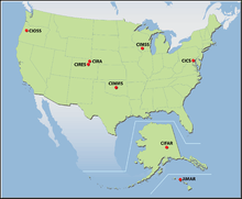
Cooperative Institutes (CIs) are non-federal academic and non-profit research institutions supported by NOAA that provide resources to the agency's mission, goals, and strategic plans.[22] Eight NOAA CIs support GOES-16:
- Cooperative Institute for Climate and Satellites (CICS)
- Cooperative Institute for Alaska Research (CIFAR)
- Cooperative Institute for Mesoscale Meteorological Studies (CIMMS)
- Cooperative Institute for Meteorological Satellite Studies (CIMSS)
- Cooperative Institute for Oceanographic Satellite Studies (CIOSS)
- Cooperative Institute for Research in the Atmosphere (CIRA)
- Cooperative Institute for Research in Environmental Sciences (CIRES)
- Joint Institute for Marine and Atmospheric Research (JIMAR)
Proving ground
Many GOES-16 products will be aimed at monitoring severe weather and helping forecasters issue earlier, more accurate, severe weather warnings. The Proving Ground was established to prepare operational forecasters for the amount of data that will be available with the GOES-R series and ensure maximum utilization when the satellites are launched and operational. Its goals are: training forecasters to use new products, identifying different utilities of each product, identifying weaknesses or errors with each product, user-feedback development, and day one readiness for GOES-R operations.[5][23]
Launch vehicle

The GOES-16 satellite launched aboard an Atlas V 541 expendable launch vehicle from Space Launch Complex 41 at Cape Canaveral Air Force Station, Florida.[24][25]
See also
References
- ↑ Lockheed Martin Geostationary Operational Environmental Satellite R-Series (GOES-R)
- ↑ Spaceflight Now AV-69 coverage
- ↑ https://www.nesdis.noaa.gov/GOES-R-Launch
- ↑ "Flyout Charts/Schedules - NOAA's Satellite and Information Service (NESDIS)". Nesdis.noaa.gov. 2015-09-21. Retrieved 2016-02-10.
- 1 2 "Proving Ground". GOES-R. NASA, NOAA. Archived from the original on February 5, 2012.
- ↑ "GOES-R Brochure" (PDF). Goes-r.gov. Retrieved 2016-02-10.
- ↑ "GOES-R Spacecraft Overview". GOES-R. NASA, NOAA. Retrieved November 2, 2014.
- ↑ "The ABI on GOES-R" (PDF). Goes-r.gov. Retrieved 2016-02-10.
- ↑ "The Geostationary Lightning Mapper (GLM) for the GOES-R Series of Geostationary Satellites" (PDF). Goes-r.gov. Retrieved 2016-02-10.
- ↑ "The Geostationary Lightning Mapper (GLM) on the GOES-R Series:" (PDF). Goes-r.gov. Retrieved 2016-02-10.
- ↑ "Lightning, Tornadoes, and the Future of NOAA Satellites [1080p". YouTube. Retrieved 2016-02-10.
- ↑ "Satnews Publishers: Daily Satellite News". Satnews.com. 2009-12-30. Retrieved 2016-02-10.
- ↑ "GOES-R EXIS Instrument Page". Goes-r.gov. 2014-07-07. Retrieved 2016-02-10.
- ↑ "GOES-R SEISS Instrument Page". Goes-r.gov. 2014-07-07. Retrieved 2016-02-10.
- ↑ "GOES-R Magnetometer". Goes-r.gov. 2014-07-07. Retrieved 2016-02-10.
- ↑ "GOES Rebroadcast". Goes-r.gov. Retrieved 2016-02-10.
- ↑ "GOES Data Collection System" (PDF). Goes-r.gov. Retrieved 2016-02-10.
- ↑ "GOES-R HRIT/EMWIN Overview page". Goes-r.gov. 2014-07-07. Retrieved 2016-02-10.
- ↑ "NOAA - Search and Rescue Satellite Aided Tracking - Welcome". Sarsat.noaa.gov. 2016-01-22. Retrieved 2016-02-10.
- ↑ "GOES-R Ground Segment Overview". Goes-r.gov. Retrieved 2016-02-10.
- ↑ "GOES-R User Readiness Overview". Goes-r.gov. 2015-09-10. Retrieved 2016-02-10.
- ↑ "CI Locations". Ci.noaa.gov. Retrieved 2016-02-10.
- ↑ "GOES-R Proving Ground Page". Goes-r.gov. 2015-06-05. Retrieved 2016-02-10.
- ↑ Braukus, Michael; Diller, George H. (April 5, 2012). "NASA Awards Launch Contract For Goes-R And Goes-S Missions". NASA. Retrieved November 2, 2014.
- ↑ Lockheed Martin Completes Assembly of Next-Generation Weather Satellite. 4 June 2015
Attributions
 This article incorporates public domain material from the National Aeronautics and Space Administration document "Mission Overview".
- This article incorporates public domain material from the National Aeronautics and Space Administration document "Proving Ground".
- This article incorporates public domain material from the National Aeronautics and Space Administration document "GOES-R Spacecraft Overview".
- This article incorporates public domain material from the National Aeronautics and Space Administration document "EUV and X-Ray Irradiance Sensors (EXIS)".
- This article incorporates public domain material from the National Aeronautics and Space Administration document "Space Environment In-Situ Suite (SEISS)".
- This article incorporates public domain material from the National Aeronautics and Space Administration document "Magnetometer (MAG)".
- This article incorporates public domain material from the National Aeronautics and Space Administration document "GOES-R Unique Payload Services (UPS)".
- This article incorporates public domain material from the National Aeronautics and Space Administration document "Program Systems Engineering Overview".
- This article incorporates public domain material from the National Aeronautics and Space Administration document "User Readiness Overview".
External links
| Predecessor SMS |  | |
|---|---|---|
| SMS derived | ||
| 1st Generation | ||
| 2nd Generation | ||
| 3rd Generation | ||
| 4th Generation | ||
| Related | ||