Fort Monroe
|
Fort Monroe | |
|
Fort Monroe Aerial Photo 2004 | |
 | |
| Location | Hampton, Virginia |
|---|---|
| Coordinates | 37°00′13″N 76°18′27″W / 37.00361°N 76.30750°WCoordinates: 37°00′13″N 76°18′27″W / 37.00361°N 76.30750°W |
| Area | 565 acres (229 ha) |
| Built | 1819–1834 |
| Website | Fort Monroe National Monument |
| NRHP Reference # |
66000912 [1] (original) 13000708 (increase) |
| VLR # | 114-0002 |
| Significant dates | |
| Added to NRHP | October 15, 1966 |
| Boundary increase | March 9, 2015 |
| Designated NHLD | December 19, 1960 [2] |
| Designated NMON | November 1, 2011 [3] |
| Designated VLR | September 9, 1969[4] |

Fort Monroe (also known as the Fort Monroe National Monument) was a military installation in Hampton, Virginia—at Old Point Comfort, the southern tip of the Virginia Peninsula. Along with Fort Wool, Fort Monroe guarded the navigation channel between the Chesapeake Bay and Hampton Roads—the natural roadstead at the confluence of the Elizabeth, the Nansemond and the James rivers. Surrounded by a moat, the seven-sided fort is the largest stone fort ever built in the United States.
During the initial exploration by the mission headed by Captain Christopher Newport in the earliest days of the Colony of Virginia, the site was identified as a strategic defensive location. Beginning by 1609, defensive fortifications were built at Old Point Comfort during Virginia's first two centuries. The first was a wooden stockade named Fort Algernourne. However, the much more substantial facility of stone to become known as Fort Monroe (and adjacent Fort Wool on an artificial island across the channel) were completed in 1834. The principal facility was named in honor of U.S. President James Monroe.[5] Throughout the American Civil War (1861–1865), although most of Virginia became part of the Confederate States of America, Fort Monroe remained in Union hands. It became notable as a historic and symbolic site of early freedom for former slaves under the provisions of contraband policies. For two years thereafter, the former Confederate President, Jefferson Davis, was imprisoned at the fort. His first months of confinement were spent in a cell of the casemate fort walls that is now part of its Casemate Museum. In the 20th century, it housed the Coast Artillery School and later the United States Army Training and Doctrine Command (TRADOC) until its decommission.
Fort Monroe was decommissioned on September 15, 2011,[6] and many of its functions were transferred to nearby Fort Eustis. Several re-use plans for Fort Monroe are under development in the Hampton community. On November 1, 2011, President Barack Obama signed a proclamation to designate portions of Fort Monroe as a National Monument. This was the first time that President Obama exercised his authority under the Antiquities Act, a 1906 law to protect sites deemed to have natural, historical or scientific significance.[3]
Description
Within the 565 acres of Fort Monroe are 170 historic buildings and nearly 200 acres of natural resources, including 8 miles of waterfront, 3.2 miles of beaches on the Chesapeake Bay, 110 acres of submerged lands and 85 acres of wetlands. It has a 332-slip marina and shallow water inlet access to Mill Creek, suitable for small watercraft.[7]
History
The land area where Fort Monroe is became part of Elizabeth Cittie [sic] in 1619, Elizabeth River Shire in 1634, and was included in Elizabeth City County when it was formed in 1643. Over 300 years later, in 1952, Elizabeth City County and the nearby Town of Phoebus agreed to consolidate with the smaller independent city of Hampton, which became one of the larger cities of Hampton Roads.
Colonial period
Arriving with three ships under Captain Christopher Newport, Captain John Smith and the colonists of the Virginia Company established the settlement of Jamestown of the British Colony of Virginia on the James River in 1607. On their initial exploration, they recognized the strategic importance of the site at Old Point Comfort for purposes of coastal defense. They initially built Fort Algernourne (1609–1612) at the location of the present Fort Monroe. It is assumed to have been a triangular stockade, based on the fort at Jamestown. Other small forts known as Fort Henry and Fort Charles were built nearby in 1610. Fort Algernourne burned in 1612.
In the latter part of August 1619, a Dutch ship, the White Lion, appeared off the coast of Old Point Comfort. Its cargo included more than 30 Africans captured from the slave ship Sao Joao Bautista. Traded for work and supplies from the English, they were the first Africans to come ashore on British-occupied land in what would become the United States. Although the Bantu Africans from Angola were considered indentured servants, their arrival is considered to mark the beginning of slavery in America.
Another fort, known only as "the fort at Old Point Comfort" was constructed in 1632. In 1728, Fort George was built on the site. Its masonry walls were destroyed by a hurricane in 1749, but the wood buildings in the fort were used by a reduced force until at least 1775. In 1781, during the Siege of Yorktown, the French West Indian fleet established a battery on the ruins of Fort George. Throughout the Colonial period, fortifications were manned at the location from time to time.
Early 19th century

Following the War of 1812, the United States realized the need to protect Hampton Roads and the inland waters from attack by sea. In March 1819, President James Monroe came up with a plan of building a network of coastal defenses. In 1822 construction began in earnest[8] on the stone-and-brick fort which would become the safeguard for Chesapeake Bay and the largest stone fort ever built in the United States. Among the original buildings is Quarters 1, designed as a residence and headquarters for Fort Monroe’s commanding officer.[9] Work continued for nearly 25 years.[10] The fort was designed by the French Napoleonic General of Engineers Simon Bernard, who had been banished from France after the defeat of Napoleon at Waterloo in 1815. It features a moat completely surrounding the inner structures.
As a young first lieutenant and engineer in the U.S. Army, Robert E. Lee was stationed there from 1831 to 1834 and played a major role in the final construction of Fort Monroe and its opposite, Fort Calhoun. He resided at Quarters 17.[11] Fort Calhoun, later renamed Fort Wool, was built on a man-made island called the Rip Raps across the navigation channel from Old Point Comfort in the middle of the mouth of Hampton Roads. The Army briefly detained the chieftain Black Hawk at Fort Monroe, following the 1832 Black Hawk War.
When construction was completed in 1834, Fort Monroe was referred to as the "Gibraltar of Chesapeake Bay." The fort mounted an impressive complement of the most powerful artillery of the time: 32-pounder guns with a range of over one mile. In conjunction with Fort Calhoun (later Fort Wool), this was just enough range to cover the main shipping channel into the area. (Decommissioned after World War II, the former Fort Wool on Rip Raps is now adjacent to the southern man-made island of the Hampton Roads Bridge-Tunnel, first completed in 1957.)
American Civil War

1860–61
Fort Monroe played an important role in the American Civil War. On December 20, 1860, South Carolina became the first state to secede from the Union. Four months later, on April 12, 1861, troops of that state opened fire on Fort Sumter in Charleston Harbor. Five days later, Virginia's legislature passed (subject to voters' ratification) the Ordinance of Secession of Virginia to withdraw from the Union and join the newly formed Confederate States of America. On 23 May 1861, voters of Virginia ratified the state's secession from the union.
President Abraham Lincoln had Fort Monroe quickly reinforced so that it would not fall to Confederate forces. It was held by Union forces throughout the Civil War, which launched several sea and land expeditions from there.
A few weeks after the Battle of Fort Sumter in 1861, U.S. Army General-in-Chief Winfield Scott proposed to President Abraham Lincoln a plan to bring the states back into the Union: Cut the Confederacy off from the rest of the world instead of attacking its army in Virginia. His Anaconda Plan was to blockade the Confederacy's coastline and control the Mississippi River valley with gunboats. In cooperation with the Navy, troops from Fort Monroe extended Union control along the coasts of the Carolinas as Lincoln ordered a blockade of the southern seaboard from the South Carolina line to the Rio Grande on April 19 and, on April 27, extended it to include the North Carolina and Virginia coasts.
On April 20 the Union Navy burned and evacuated the Norfolk Navy Yard, destroying nine ships in the process, keeping Fort Monroe at Old Point Comfort as the last bastion of the United States in Tidewater Virginia. The Confederacy's occupation of Norfolk gave it a major shipyard and thousands of heavy guns, but they held it for only one year. Confederate Brigadier General Walter Gwynn, who commanded the Confederate defenses around Norfolk, erected batteries at Sewell's Point, to protect Norfolk and to control Hampton Roads.
The Union dispatched a fleet to Hampton Roads to enforce the blockade. On May 18–19, 1861, Federal gunboats based at Fort Monroe exchanged fire with the Confederate batteries at Sewell's Point. The little-known Battle of Sewell's Point resulted in minor damage to either side. Several land operations against Confederate forces were mounted from the fort, notably the Battle of Big Bethel in June 1861.
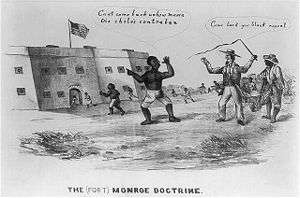
On May 27, 1861, Major General Benjamin Butler made his famous "contraband" decision, or "Fort Monroe Doctrine", determining that escaping male slaves who reached Union lines would be considered contraband and not be returned to bondage. The order resulted in thousands of slaves fleeing to Union lines around Fort Monroe, which was Butler's headquarters in Virginia. Fort Monroe became called "Freedom's Fortress", as any slave reaching it would be free. By the fall, the Army had built the Great Contraband Camp to try to house the families. It was the first of more than 100 that would be established by war's end, and the Roanoke Island Freedmen's Colony (1863–1867), which started as a contraband camp.
Mary S. Peake was teaching the children of freedmen to read and write near Fort Monroe. She was the first black teacher hired by the American Missionary Association (AMA), a northern missionary group led by black and white ministers from the Congregational, Presbyterian and Methodist denominations, who strongly supported education of freedmen. Soon she was teaching children during the day and adults at night. The AMA sponsored hundreds of northern teachers and hired local teachers in the south; it founded more than 500 local schools and 11 colleges for freedmen and their children.
Under Gen. Butler's command, Fort Monroe was the site of a military balloon camp under the flight direction of aeronaut John LaMountain. The Union Army Balloon Corps was being developed at Fort Corcoran near Arlington under the presidentially appointed Prof. Thaddeus S. C. Lowe. At the same time, LaMountain, who was vying for position as Chief Aeronaut, had gained the confidence of Butler in using his balloon Atlantic for aerial observations. LaMountain is credited with having made the first successful report from an aerial station that was of practical military intelligence. LaMountain was later reassigned to Lowe's balloon corps, but after a period of in-fighting with Lowe, he was released from military service. Lowe eventually assigned regular military balloons to Fort Monroe.
1862

In March 1862, the naval Battle of Hampton Roads took place off Sewell's Point between the first ironclad warships, CSS Virginia and USS Monitor. While the outcome was inconclusive, the battle marked a change in naval warfare and the end to wooden fighting ships.
Later that spring, the continuing presence of the Union Navy based at Fort Monroe enabled federal water transports from Washington, D.C., to land unmolested to support Major General George B. McClellan's Peninsula Campaign. Formed at Fort Monroe, McClellan's troops moved up the Virginia Peninsula during the spring of 1862, reaching within a few miles of the gates of Richmond about 80 miles to the west by June 1. For the next 30 days, they laid siege to Richmond. Then, during the Seven Days Battles, McClellan fell back to the James River well below Richmond, ending the campaign. Fortunately for McClellan, during this time, Union troops regained control of Norfolk, Hampton Roads, and the James River below Drewry's Bluff (a strategic point about 8 miles south of Richmond).
Beginning in 1862 Fort Monroe was also used as a transfer point for mail exchange. Mail sent from states in the Confederacy addressed to locations in the Union had to be sent by flag-of-truce and could only pass through at Fort Monroe where the mail was opened, inspected, resealed, marked and sent on. Prisoner of war mail from Union soldiers in Confederate prisons was required to be passed through this point for inspection.[12][13]
1864–96

In 1864, the Union Army of the James under Major General Benjamin Butler was formed at Fort Monroe. The 2nd Regiment, United States Colored Cavalry, mustered at Fort Monroe on December 22, 1864, and the 1st Regiment, United States Colored Cavalry mustered the same day at nearby Camp Hamilton. The Siege of Petersburg during 1864 and 1865 was supported on the James River from a base at City Point (now Hopewell, Virginia). Maintaining the control of Hampton Roads at Fort Monroe and Fort Wool was crucial to the naval support Grant required for the successful Union campaign to take Petersburg, which was the key to the fall of the Confederate capital at Richmond. As Petersburg fell, Richmond was evacuated in 1865 on the night of April 2–3. That night, Confederate President Jefferson Davis and his cabinet escaped Richmond, taking the Richmond and Danville Railroad to move first to Danville and then North Carolina. However, the cause was lost, and Confederate General Robert E. Lee surrendered what was left of the Army of Northern Virginia to Grant at Appomattox Court House the following week.
After the last Confederate cabinet meeting was held on April 26, 1865, at Charlotte, North Carolina, Jefferson Davis was captured at Irwinville, Georgia, and placed under arrest. He was briefly confined in an unheated, open casemate until the Union Surgeon John J. Craven recommended more humane care for Mr. Davis. General Nelson A. Miles approved changes and even moved Mr. Davis to more hospitable quarters. He was held at Fort Monroe for two years. Some historians have speculated that his treatment in captivity was intended to be lethal. In poor health, Davis was released in May, 1867, on bail, which was posted by prominent citizens of both Northern and Southern states, including Horace Greeley and Cornelius Vanderbilt, who had become convinced he was being treated unfairly. The federal government proceeded no further in its prosecution due to the constitutional concerns of U.S. Supreme Court Chief Justice Salmon P. Chase.
The Journal of the United States Artillery was founded at Fort Monroe in 1892 by First Lieutenant (later General) John Wilson Ruckman and four other officers of the Artillery School. Ruckman served as the editor of the Journal for four years (July 1892 to January 1896) and published several articles therein afterward. One publication by West Point notes Ruckman's “guidance” and “first-rate quality” work were obvious as the Journal “rose to high rank among the service papers of the world”. The Journal was renamed the Coast Artillery Journal in 1922 and the Antiaircraft Journal in 1948.
Twentieth century
Over time the armament at Fort Monroe was improved, taking advantage of new technologies. In addition, the fort controlled several sub-installations around Hampton Roads, making the area one of the most heavily defended in the United States.
The Jamestown Exposition held in 1907 at Hampton Roads, featured an extensive naval review, including the Great White Fleet. Beginning in 1917, the former exposition site at Sewell's Point became a major base of the United States Navy. Currently, Norfolk Navy Base is the base supporting naval forces operating in the Atlantic Ocean, Mediterranean Sea, and Indian Ocean. It is the world's largest naval station by number of military members supported.
Coast Artillery School
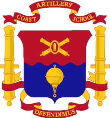
In 1907 the Coast Artillery School was established along with the U.S. Army Coast Artillery Corps. New buildings were constructed for classrooms and barracks (the library and school buildings compleated in 1909). As part of the schools responsibility the "Coast Artillery Journal" was published under the supervision of the commandant. The school operated until 1946 when most of the coast artillery was disbanded, and the school was moved to Fort Winfield Scott.
.jpg)

Commandants list
| Image | Rank | Name | Begin Date | End Date | Notes |
|---|---|---|---|---|---|
 | Lieutenant colonel | Ramsay D. Potts | 22 February 1904 | 11 August 1906 | a[›] |
 | Lieutenant colonel | George F. E. Harrison | 24 October 1906 | 14 January 1909 | a[›] |
 | Lieutenant colonel | Clarence Page Townsley | 06-February-1909 | 7 September 1911 | a[›] |
 | Lieutenant colonel | Frederick S. Strong | 8 September 1911 | 27 February 1913 | a[›] |
 | Colonel | Ira A. Haynes | 18 February 1913 | 16 October 1916 | a[›] |
 | Colonel | Stephen M. Foote | 1 October 1916 | 23 August 1917 | a[›] |
 | Colonel | John A. Lundeen | 23 August 1917 | 30 March 1918 | a[›] |
 | Colonel | Frank K. Fergusson | 30 March 1918 | 11 September 1918 | a[›] |
| Colonel | Robert R. Welshimer | 8 September 1918 | 29 January 1919 | a[›] | |
 | Colonel | Eugene Reybold | 29 January 1919 | 19 January 1920 | a[›] |
| Colonel | Jacob C. Johnson | 19 January 1920 | 3 November 1920 | a[›] | |
 | Colonel | Richmond P. Davis | 28 April 1921 | 28 December 1922 | a[›] |
 | Brigadier General | William Ruthven Smith | 11 January 1923 | 20 December 1924 | a[›] |
 | Brigadier General | Robert Emmet Callan | 20 December 1924 | 3 June 1929 | a[›] |
 | Brigadier General | Henry D. Todd | 28 August 1929 | 31 August 1930 | a[›] |
 | Brigadier General | Stanley Dunbar Embick | 1 October 1930 | 25 April 1932 | a[›] |
 | Brigadier General | Joseph P. Tracy | 31 August 1932 | 1 December 1936 | a[›] |
 | Brigadier General | John W. Gulick | 3 January 1937 | 12 October 1938 | a[›] |
| Brigadier General | Frederick H. Smith | 21 November 1938 | 1 October 1940 | a[›] | |
| Brigadier General | Frank S. Clark | 10 October 1940 | 15 January 1942 | a[›] | |
| Brigadier General | Lawrence B. Weeks | 15 January 1942 | 1 October 1945 | a[›] | |
 | Brigadier General | Robert T. Frederick | 1 November 1945 | 19 August 1947 | a[›] |

During World War I and World War II Fort Monroe and Fort Wool were used to protect Hampton Roads and the important inland military and civilian resources. The fort installed the first anti-submarine net in America in February 1917 stretching to Fort Wool.
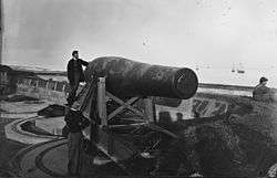
By World War II, Fort Monroe served as headquarters for an array of coast artillery guns ranging from 3-inch rapid fire guns to 16-inch guns capable of firing a 2,000 pound projectile 25 miles. In addition, the Army controlled submarine barriers and underwater mine fields. But this vast array of armaments was made largely obsolete by the end of the Second World War due to the development of the long-range bomber and the refinement of naval aviation.
Since World War II, it served as the major headquarters for training soldiers for war. In 1973, Fort Monroe became home to the United States Army Training and Doctrine Command (TRADOC), which combines the recruitment, training and education of soldiers with the development of operational doctrine. At the turn of the 21st century while as a United States Army post, Fort Monroe supported a work population of some 3000, including 1000 people in uniform.

Base Realignment and Closure
The 2005 Base Realignment and Closure Commission of the Department of Defense released a list on 13 May 2005 of military installations recommended for closure or realignment, among which was Fort Monroe. The list was approved by President George W. Bush on 15 September 2005 and submitted to Congress. Congress failed to act within 45 legislative days to disapprove the list in its entirety, and the BRAC recommendations subsequently became law. Installations on the BRAC list by law must close within six years.
Many of its functions were transferred to nearby Fort Eustis, which was named for Fort Monroe's first commander, General Abraham Eustis, a noted artillery expert.
Fort Monroe today
As several re-use plans for Fort Monroe are, as of December 2011, under development in the Hampton community, plans for its long-term use cannot be yet documented.
Fort Monroe has become a popular historical site. The Casemate Museum, opened in 1951, depicts the history of Fort Monroe and Old Point Comfort, with special emphasis on the Civil War period. It offers a view of Confederate President Jefferson Davis' prison cell. Also shown are the quarters occupied by 1st Lt. Robert E. Lee in 1831–34, and the quarters where President Abraham Lincoln was a guest in May 1862.
The area inside of the moat was to be used for a boarding high school in the year 2016-17. "Buildings once reserved for the school are now fair game for any developer because a letter of intent between the STEAM Academy's organizers and Fort Monroe Authority has expired."[14]
Redevelopment possibilities

The Fort Monroe Federal Area Development Authority (FMFADA) was established in 2007 by legislative action of the Virginia General Assembly as a public body corporate and as a political subdivision of the Commonwealth of Virginia, to serve as the official Local Redevelopment Authority (LRA) recognized by the Department of Defense. The task of the FMFADA commission was to study, plan, and recommend the best use of the resources that remain when the Army closed the fort in September 2011. The Fort Monroe Reuse Plan was officially adopted August 2008.[15] The FMFADA relies on the expertise of national consultants in the areas of BRAC law, environmental engineering, historic architecture and preservation planning, structural engineering, housing market analysis, commercial/retail analysis, public relations/marketing, and tourism planning.
The Virginia Department of Historic Resources and the Department of Environmental Quality have major regulatory authority that influences the work.The state took a lead role in planning because most of the land that Fort Monroe occupies will revert to the Commonwealth when the Army closes the fort. The effort was guided by three priorities — keep Fort Monroe open to the public, respect the rich history, and advance economic sustainability.
The Authority is an 18-member body consisting of appointees from the city of Hampton, the Virginia House of Delegates and Senate and the Virginia governor’s cabinet, with two specialists in historic preservation and heritage tourism.
Virginia historically has given local government strong consideration in determining disposition at that point, such as occurred at Fort Pickett in Nottoway County (near Blackstone) in the Southside region. Given the historic significance of the post, the decommissioned fort will be a good candidate for heritage tourism along with many other historical sites throughout the greater Hampton Roads area. Redevelopment to help offset the economic loss of a base closure is a priority.
Fort Monroe is a National Historic Landmark and the moated fort and the 190 historic buildings on Old Point Comfort will be protected with historic preservation design guidelines for reuse. Old Point Comfort is prime development property and some mixed used new construction will be allowed within strict guidelines. For example, the historic Chamberlin Hotel was leased to a developer by the Army and beautifully renovated as retirement apartments.
The National Park Service and the Fort Monroe FADA have been communicating to identify the best way to achieve a partnership and the park service presented several options.[16] In 2013, Governor Bob McDonnell approved a new master plan to revitalize the site and the National Trust for Historic Preservation cited the site as one of ten historic sites saved that year.[17] In August 2014 only 2 businesses had moved in.[18]
Climate
The climate in this area is characterized by hot, humid summers and generally mild to cool winters. According to the Köppen Climate Classification system, Fort Monroe has a humid subtropical climate, abbreviated "Cfa" on climate maps.[19]
See also
- 2nd Air Defense Artillery Regiment (United States)
- 12th Coast Artillery (United States)
- 51st Coast Artillery Regiment (United States)
- Chapel of the Centurion
- Fort Wool
- Quarters 1
- Quarters 17
- Sewell's Point
- Battle of Hampton Roads
- United States Army Training and Doctrine Command
- The Chamberlin
- List of Underground Railroad sites
- List of National Historic Landmarks in Virginia
- National Register of Historic Places listings in Hampton, Virginia
References
- ↑ National Park Service (2007-01-23). "National Register Information System". National Register of Historic Places. National Park Service.
- ↑ "Fort Monroe". National Historic Landmark summary listing. National Park Service. Retrieved 2008-06-23.
- 1 2 Macauley, David (1 Nov 2011). "It's Official - President Obama confirms Fort Monroe park designation". Daily Press. Retrieved 1 November 2011.
- ↑ "Virginia Landmarks Register". Virginia Department of Historic Resources. Retrieved 19 March 2013.
- ↑ Gannett, Henry (1905). The Origin of Certain Place Names in the United States. Govt. Print. Off. p. 129.
- ↑
- ↑ http://www.fmauthority.com/about/fact-sheet.php
- ↑ Konstam, Angus & Spedaliere, Donato: American Civil War Fortifications (1): Coastal brick and stone forts, p.19; Osprey Publishing, 2013
- ↑ Katherine D. Klepper (December 2009). "National Register of Historic Places Inventory/Nomination: Quarters 1" (PDF). Virginia Department of Historic Resources.
- ↑ "Fort Monroe During the Civil War". Kenmore Stamp Company. Retrieved 4 February 2011.
- ↑ Katherine D. Klepper (n.d.). "National Register of Historic Places Inventory/Nomination: Quarters 17" (PDF). Virginia Department of Historic Resources.
- ↑ "Civilian Flag-of-Truce Covers". Smithsonian National Postal Museum. Retrieved 17 November 2010.
- ↑ "Prisoner mail exchange". Prisoner of War mail, Smithsonian National Postal Museum. Retrieved 17 November 2010.
- ↑ http://www.dailypress.com/news/hampton/dp-nws-fort-monroe-steam-academy-20150405-story.html
- ↑ "Fort Monroe Federal Area Development Authority". n.d.
- ↑ "Making the case for Fort Monroe". Hamptonroads.com. The Virginian Pilot. Retrieved 26 April 2015.
- ↑ staff (January 5, 2014). "A look at 10 historic sites save, 10 lost in 2013". Associated Press as reported by the Post Crescent. p. F3.
- ↑ Robert Brauchle. "Businesses slow to move to Fort Monroe". Daily Press. Retrieved 5 September 2014.
- ↑ Climate Summary for Fort Monroe
External links
| Wikimedia Commons has media related to Fort Monroe, Virginia. |
| Wikisource has the text of a 1921 Collier's Encyclopedia article about Fort Monroe. |
- Fort Monroe National Monument
- Fort Monroe Casemate Museum
- Fort Monroe During the Civil War in Encyclopedia Virginia
- Fort Monroe Federal Area Development Authority
- Fort Monroe Installation Overview from ArmyUSA.org.
- GlobalSecurity.org Fort Monroe webpage
- TRADOC website
- U.S. Department of Defense website
- Site for Citizens for a Fort Monroe National Park (CFMNP.org)
- 2nd Regiment, United States Colored Cavalry
- 1st Regiment, United States Colored Cavalry
- Google Earth KML File
- "How Slavery Really Ended in America" by Adam Goodheart, New York Times, April 1, 2011
- Archival Records
- "Fort Monroe Records at the Library of Virginia", at Virginia Memory
- fort monroe film clips
- The short film Big Picture: Historic Fort Monroe is available for free download at the Internet Archive
- Fort Monroe, Hampton, Hampton, VA: 71 photos, 7 measured drawings, 37 data pages, and 4 photo caption pages at Historic American Buildings Survey
- Fort Monroe, Fortress, Hampton, Hampton, VA: 57 photos, 5 color transparencies, and 6 photo caption pages at Historic American Buildings Survey
- Fort Monroe, Bandstand, Fenwick Road, Hampton, Hampton, VA: 2 photos, 1 color transparency, and 2 photo caption pages at Historic American Buildings Survey
- Fort Monroe, Building No. 168, Murray Street, Hampton, Hampton, VA: 11 photos, 6 data pages, and 4 photo caption pages at Historic American Buildings Survey
- Fort Monroe, Chamberlin Hotel Garage, McNair Drive, Hampton, Hampton, VA: 5 photos, 5 data pages, and 2 photo caption pages at Historic American Buildings Survey
- Fort Monroe, Isolation Hospital, 20 Moat Walk, Hampton, Hampton, VA: 4 photos, 8 data pages, and 1 photo caption page at Historic American Buildings Survey
- Fort Monroe, Main Gate, U.S. Routes 60 & 258, Hampton, Hampton, VA: 9 measured drawings at Historic American Buildings Survey
- Fort Monroe, Building No. 226, Off Fenwick Road, Hampton, Hampton, VA: 5 photos, 3 data pages, and 1 photo caption page at Historic American Buildings Survey
- Fort Monroe, Parade Ground, Hampton, Hampton, VA: 8 photos and 1 photo caption page at Historic American Buildings Survey
- Fort Monroe, Post Office, Ingalls Road, Hampton, Hampton, VA: 1 photo and 1 photo caption page at Historic American Buildings Survey
- Fort Monroe, Building Nos. 80 & 100, Northeast corner of Ingalls & Patch Roads, Hampton, Hampton, VA: 12 photos, 3 color transparencies, and 2 photo caption pages at Historic American Buildings Survey
| People |
| |
|---|---|---|
| Places | ||
| Events |
| |
| Topics | ||
| Related |
| |
See also: Slavery in the United States and Slavery in Canada | ||

