Frying Pan Shoals
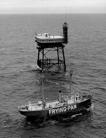
The Frying Pan Shoals are a long, shifting area of shoals off the coast of Cape Fear in North Carolina, United States. The shoals have been a hazard to ships in the area since the beginning of European exploration of the area; the area is littered with shipwrecks. The southern edge of the shoals have been marked by a lightship, a light tower and a buoy. From May 1994 to August 2008, over 130 new shipwreck locations have been discovered in the area encompassing Frying Pan Shoals. The area is also a great fishing destination.
In May 2010, the United States government sold the Frying Pan Shoals Light Station through a sealed bid auction. The winning bidder (Richard Neal, a private US citizen) made his plans public to renovate and return the light station to use as a private rental property. The tower as it is known by locals is significant not only for its longevity but also since when out of sight of land, it is a commonly referenced location and as such is marked on many navigation charts with its GPS coordinates (33° 29' N 77° 35.5' W).
In August 2011, the Frying Pan Tower was directly hit by Hurricane Irene with measured winds of 67 MPH and waves of 28 ft. An observational flight the day after the storm, August 28, 2011, showed that the tower had no visible damage from the impact. A video of the flight is available from YouTube by searching for Frying Pan Tower and Hurricane Irene and was listed in an article in Time Magazine on light houses that have been restored to bed and breakfast facilities.
In November 2012, Hurricane Sandy went within a few dozen miles of the Frying Pan Tower but due to its strength, the only issue was a few disturbed ceiling tiles due to a window being left open. Since 2010, the Frying Pan Tower (light station) has been privately owned by Richard Neal and has been re-opened as a functioning but "rustic" bed and breakfast that has volunteers, guests and news crews coming out to experience the beauty of the ocean, a near perfect "dark sky" for viewing the Milky Way or clearly the moon and large and varied fish species and turtles. Frying Pan Shoals Light Station is one of 15 light stations off the United States coastline most of which have been dismantled or destroyed by weather and time.
External links
Coordinates: 33°48′04″N 77°56′49″W / 33.80111°N 77.94694°W