Frye Island, Maine
| Frye Island, Maine | |
|---|---|
| Town | |
| Motto: "A Community Managed By Its Owners"[1] | |
 Location in Cumberland County and the state of Maine. | |
| Coordinates: 43°50′24″N 70°31′35″W / 43.84000°N 70.52639°W | |
| Country | United States |
| State | Maine |
| County | Cumberland |
| Incorporated | 1998 |
| Area[2] | |
| • Total | 1.60 sq mi (4.14 km2) |
| • Land | 1.34 sq mi (3.47 km2) |
| • Water | 0.26 sq mi (0.67 km2) |
| Elevation | 269 ft (82 m) |
| Population (2010)[3] | |
| • Total | 5 |
| • Estimate (2012[4]) | 5 |
| • Density | 3.7/sq mi (1.4/km2) |
| Time zone | Eastern (EST) (UTC-5) |
| • Summer (DST) | EDT (UTC-4) |
| ZIP code | 04071 |
| Area code(s) | 207 |
| FIPS code | 23-27025 |
| GNIS feature ID | 1802735 |
| Website |
www |
Frye Island is a town in Cumberland County, Maine, United States. Located in Sebago Lake, the island is accessed via a public car ferry from Raymond Neck, or by private boat. All residents of the resort town are seasonal. The majority of property owners hail from New England area states (Massachusetts, Connecticut, Rhode Island and New Hampshire) however there are many other states also represented on the island. Frye Island is vacant from November through April, and the ferry does not operate during that time due to the formation of thick ice during cold winter months. It is part of the Portland–South Portland–Biddeford, Maine Metropolitan Statistical Area. The town had a population of five at the 2010 census.
History
It was included in the 1750 grant made by the Massachusetts General Court to Captain Moses Pearson, Captain Humphrey Hobbs and their respective companies of soldiers for services during the French and Indian Wars. Pearsontown Plantation was first settled in the 1750s, then incorporated as the town of Standish on November 30, 1785. Frye Island, named for Captain Joseph Frye, seceded to become a separate town on July 1, 1998.[5]
A popular legend on Frye Island tells of Captain Frye and his escape from a tribe of Native Americans in Portland. While being chased, Captain Frye came upon a large rock, now known as Frye's Leap, and had no way of going around it. Captain Frye made the decision to jump and swim across the channel to Frye Island. Today, many people go to Frye's Leap to reenact the famous jump. [6]
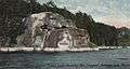 Frye's Leap c. 1905
Frye Island is composed of approximately 1,000 mostly wooded acres interlaced with 22 miles (35 km) of dirt roads. The speed limit is 20 mph (32 km/h). Many of the homes are built on waterfront property overlooking Sebago Lake. Real estate on Frye Island has skyrocketed over the past decade or so, and many of the waterfront homes assess at extremely high values. On the island, there are two marinas, various athletic and recreational facilities, several public beaches, a convenience store, an ice cream stand, a restaurant with a bar, known as the Frye's Leap Cafe, and a golf club with a lounge that is open to the public.[5]
The island is accessed by twin 65-foot (20 m) single-deck car ferries that are owned and operated by the town. They run every half-hour from early in the morning until late in the evening during July and August, reduced somewhat in off-season. The trip takes about 7 minutes. Walk-on passengers are permitted, but there is no passenger parking at the ferry landings.[7]
Traditions
Independence Day is the most celebrated holiday on the island. Each year a walk and run is held among many other festivities. Particularly of note is the town's yearly 4 July fireworks display. People from all around Sebago gather to view the fireworks, either by boat or from the beach.
Geography
Frye Island is approximately 1.5 miles (2.4 km) wide (at the widest point) and 2.5 miles (4.0 km) long. According to the United States Census Bureau, the town has a total area of 1.60 square miles (4.14 km2), of which, 1.34 square miles (3.47 km2) of it is land and 0.26 square miles (0.67 km2) is water.[2] Frye Island is situated in Sebago Lake.
Demographics
| Historical population | |||
|---|---|---|---|
| Census | Pop. | %± | |
| 2010 | 5 | — | |
| Est. 2014 | 5 | [8] | 0.0% |
2010 census
As of the census[3] of 2010, there were 5 people, 2 households, and 2 families residing in the town. The population density was 3.7 inhabitants per square mile (1.4/km2). There were 481 housing units at an average density of 359.0 per square mile (138.6/km2). The racial makeup of the town was 100.0% White.
There were 2 households of which 50.0% had children under the age of 18 living with them and 100.0% were married couples living together. 0.0% of all households were made up of individuals. The average household size was 2.50 and the average family size was 2.50.
The median age in the town was 30.8 years. 20% of residents were under the age of 18; 0.0% were between the ages of 18 and 24; 40% were from 25 to 44; 0.0% were from 45 to 64; and 40% were 65 years of age or older. The gender makeup of the town was 60.0% male and 40.0% female.
References
- ↑ "Frye Island, Maine". Frye Island, Maine. Retrieved August 26, 2012.
- 1 2 "US Gazetteer files 2010". United States Census Bureau. Retrieved 2012-12-16.
- 1 2 "American FactFinder". United States Census Bureau. Retrieved 2012-12-16.
- ↑ "Population Estimates". United States Census Bureau. Retrieved 2013-07-06.
- 1 2 Town of Frye Island
- ↑ George J. Varney, "History of Standish (and Frye Island), Maine" (1886)
- ↑ Wright, Virginia. "Frye Island: Part-time Town". Down East: The Magazine of Maine (July 2009).
- ↑ "Annual Estimates of the Resident Population for Incorporated Places: April 1, 2010 to July 1, 2014". Retrieved June 4, 2015.
- ↑ "Census of Population and Housing". Census.gov. Retrieved June 4, 2015.
External links
- Town of Frye Island official website
- Maine.gov -- Frye Island, Maine
- Maine Genealogy: Frye Island, Cumberland County, Maine
- Official website for the July 4th Walk/Run
Municipalities and communities of Cumberland County, Maine, United States | ||
|---|---|---|
| Cities | 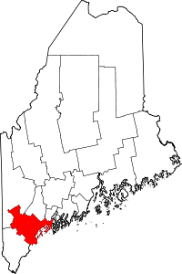 | |
| Towns | ||
| CDPs | ||
| Other villages | ||
Coordinates: 43°50′50″N 70°31′08″W / 43.84722°N 70.51889°W