Fruška Gora
| Fruška Gora Фрушка Гора | |
|---|---|
 | |
| Highest point | |
| Elevation | 539 m (1,768 ft) [1] |
| Coordinates | 45°09′04″N 19°42′40″E / 45.1511°N 19.7111°ECoordinates: 45°09′04″N 19°42′40″E / 45.1511°N 19.7111°E |
| Geography | |
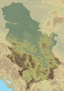 Fruška Gora Фрушка Гора Location in Serbia (map including Kosovo) | |
| Location | Syrmia / Serbia |
| Parent range | Pannonian island mountains |
|
IUCN category II (national park) | |
|
Fruška Gora National Park | |
| Area | 255 km² |
| Established | 1960 |

Fruška Gora is a mountain in north Srem. Most of it is located within Srem, Serbia, but a smaller part on its western side overlaps the territory of Croatia. Sometimes, it is also referred to as jewel of Serbia, due to its beautiful landscape protection area, nature and its picturesque countryside.
Name
In Serbian, it is known as Fruška gora (pronounced [frûʃkaː ɡǒra], Фрушка гора), in Hungarian as Tarcal (also Almus-hegy or Árpatarló), in German as Frankenwald, and in Latin as Alma Mons. In Medieval Greek, it was known as Frangochoria.
The mountain's name originates in the old Serbian word "Fruzi" of which singular form is "Frug"; and its adjective is Fruški, which was used for naming the Frankish people. The name of "Fruška Gora" is "Frankish mountain" in English whose meaning is based on describing a historical event, viz, the mountain served as a natural border when Frankish campaigns were set up in the area. In the time of the Roman Empire, its name was Alma Mons "fertile mount".
Features
To the north, the mountain is bordered by the Danube river. Lengthwise, it is approximately 80 km from east to west and is 15 km from north to south. Its highest peak is Crveni Čot at 539 m.
The slopes of Fruška Gora are perfectly suited for growing grape arbors on there, and there are many wine-makers producing Traminer, Riesling and other wines in the region. Many people have been captivated by its picturesque beauty, due to its outstanding location which is famous for the peaceful and lucrative lifestyles of its inhabitants, and a perfect destination for sightseeing where tourists can relax and enjoy themselves in the spectacular natural environment.
Since 1960, there has been a large national park in the Fruška Gora that attracts a lot of visitors every year. After the fall of communism, the Serbian Orthodox Church got 10,000 hectares restitution in the area of their nationalized properties.[2]
History
There are traces of human habitation in this area that date from neolithic times. Before the Roman conquest, Illyrians and Celts inhabited this region. In 31 AD, this area was conquered by the Romans and was included into Pannonia province. The Danube river was a border of the Roman Empire (Limes), and on the northern side of the mountain several Roman border fortresses were built.
In the Middle Ages, this area was settled by Quadi, Huns, Goths, Gepids, Slavs, Avars, Bulgarians, Pechenegs and Hungarians. In the 11th century, when Christianity was split between Catholicism and Orthodoxy, both communities had their churches in this region. A very important group of Serb medieval monasteries was formed on the mountain.
During the time, the area was part of the Hun Empire, the Ostrogothic Kingdom, the Gepid Kingdom, the Lombard state, the Byzantine Empire, the Avar Khaganate, the Frankish Empire, the Bulgarian Empire, Pannonian Croatia, the Kingdom of Hungary, the Ottoman Empire, the Habsburg Monarchy, the Austrian Empire, Austria-Hungary, the State of Slovenes, Croats and Serbs, the Kingdom of Serbia, the Kingdom of Serbs, Croats and Slovenes, the Kingdom of Yugoslavia, Socialist Federal Republic of Yugoslavia, Serbia and Montenegro, and now is within the Republic of Serbia.
During World War II, this area was occupied by the Axis Powers, and Fruška Gora was an important center of partisan resistance movement. A liberated partisan territory was formed in this region.
Population and settlements
In 1991, population of Fruška Gora region numbered 114,263 people. Settlements in the area are including 23 villages, as well as several towns, which are located on the edge of the mountain. These towns are: Šid, Beočin, Petrovaradin, Sremska Kamenica, Sremski Karlovci, Irig and Ilok.
Monasteries


Thanks to its hospitable environment, there are also over a dozen Serbian Orthodox monasteries located on Fruška Gora. According to historical data, these monastic communities were historically recorded since the first decades of the 16th century. Legends, however, place their founding to the period between the 12th and 15th centuries. The monasteries are concentrated in an area 50 kilometers long, and 10 kilometers wide. In the course of centuries of their existence, these monasteries sustained the spiritual and political life of the Serbian nation. In the eighteenth century the monasteries became the home of monks from Rača monastery in the Bajina Bašta municipality by the Drina River. These monks were writers famous for their illuminated manuscripts.
Fruška Gora Monasteries were declared Monuments of Culture of Exceptional Importance in 1990, and are protected by Serbia.
List of monasteries:
- Beočin – The time of founding is unknown. It is first mentioned in Turkish records dated in 1566/1567.
- Bešenovo – According to the legend, the Bešenovo monastery was founded by Serbian King Dragutin at the end of the 13th century. The earliest historical records about the monastery date from 1545.
- Velika Remeta – Traditionally, its founding is linked to King Dragutin. The earliest historical records about the monastery date to 1562.
- Vrdnik-Ravanica – The exact date of its founding is unknown. The records indicate that the church was built at the time of Metropolitan Serafim, in the second half of the 16th century.
- Grgeteg – According to tradition the monastery was founded by Zmaj Ognjeni Vuk (Despot Vuk Grgurević) in 1471. The earliest historical records about the monastery date to 1545/1546.
- Divša – It is believed to have been founded by Despot Jovan Branković in the late 15th century. The earliest historical records about the monastery date to the second half of the 16th century.
- Jazak – The monastery was founded in 1736.
- Krušedol – The monastery was founded between 1509 and 1516, by Bishop Maksim (Despot Đorđe Branković) and his mother Angelina.
- Kuveždin – Traditionally, its foundation is ascribed to Stefan Štiljanović. The first reliable records of it are dated in 1566/1569.
- Mala Remeta – The foundation is traditionally ascribed to the Serbian King Dragutin. The earliest historical records relating to the monastery are dated to the middle of the 16th century.
- Novo Hopovo – According to tradition, the monastery was built by the Despots of the Branković dynasty. The first reliable mention of the monastery is dated to 1641.
- Privina Glava – According to the legends, Privina Glava was founded by a man named Priva, in the 12th century. The earliest historical records about the monastery are dated in 1566/1567.
- Petkovica – According to the tradition, it was founded by the widow of Stefan Štiljanović, Despotess Jelena. The earliest historical records mentioning the monastery are dated to 1566/1567.
- Rakovac – According to a legend written in 1704, Rakovac was founded by a certain man, Raka, courtier of Despot Jovan Branković. The legend states that Raka erected the monastery in 1498. The earliest historical records mentioning the monastery are dated to 1545/1546.
- Staro Hopovo – According to the tradition, the monastery was founded by Bishop Maksim (Despot Đorđe Branković). The first reliable mention of the monastery dates back to 1545/1546.
- Šišatovac – The foundation of the monastery is ascribed to the refugee monks from the Serbian monastery of Žiča. The reliable facts illustrating the life of the monastery date back from the mid 16th century.
See also
- Fruškogorski maraton
- Lake Ledinci
- Pannonian Island Mountains
- List of mountains in Serbia
- Spatial Cultural-Historical Units of Great Importance
Notes
- ↑ Jovan Đokić. "Katalog planina Srbije". PSD Kopaonik Beograd.
- ↑ Crkva neće novac za šume
References
- Slobodan Ćurčić - Olivera Dobrivojević - Gordana Stojaković, Fruška gora: turistički vodič, Novi Sad - Beograd, 2002.
- Milorad Grujić, Vodič kroz Novi Sad i okolinu, Novi Sad, 2004.
- Gvozden Perković, Verski objekti na tlu Vojvodine, Novi Sad, 2006.
External links
| Wikimedia Commons has media related to Fruška Gora. |
- National Park Fruška Gora
- Tourist Guide trough Fruška Gora Fruškać
- The monasteries of Fruška Gora
- Photo Gallery of Fruška Gora on www.wild-serbia.com
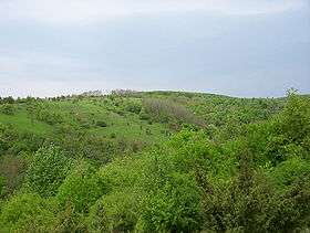
 Fruška Gora, a view from the south.
 Satellite view of Fruška Gora.
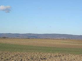
 Fruška Gora, a view from Subotica Boulevard (Boulevard of Europe) in Novi Sad.
 Fruška Gora mountain.
| Archaeological sites |  | |
|---|---|---|
| Cultural Monuments | ||
| Historic Landmarks | ||
| Spatial Cultural-Historical Units | ||
Seven Serbian Wonders of Construction
| ||
Seven Serbian Wonders of Nature
| ||