Front Street (Philadelphia)
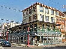 Corner of South St. (left) and Front St. (right) | |
| Location | Philadelphia and Cheltenham Township, Pennsylvania |
|---|---|
| South end | Pattison Avenue in South Philadelphia |
| Major junctions |
Washington Avenue in South Philadelphia South Street in Center City Walnut Street in Penn's Landing Chestnut Street in Penn's Landing Market Street in Penn's Landing Girard Avenue in Fishtown Cheltenham Avenue in East Oak Lane/Cheltenham Township |
| North end | Ashbourne Road in Cheltenham Township |
Front Street in Philadelphia, Pennsylvania is a north-south street running parallel to and near the Delaware River. Built when the city was laid out by William Penn in 1682, it was the first street surveyed and built in the new colony of Pennsylvania. As part of the King's Highway, which extended from Boston to Charleston, South Carolina, and as the waterfront of Philadelphia's port, it was the most important street in the city from its founding into the nineteenth century.[1]
Front Street is the origin street of Philadelphia's numbered streets. There is no First Street, Front Street exists in its place, and numbered streets begin at the next major block with Second Street, about one-tenth mile west.
At least three stations of SEPTA's Market–Frankford Line are built above Front Street. They include Girard Station,[2] Berks Station,[3] and York–Dauphin Station. SEPTA gives the address of also Spring Garden Station as Front Street, by which pedestrians have access, but its platform lies in the median of Interstate 95 over Spring Garden Street, just west of Front Street.
Historic sites
The South Front Street Historic District, which includes numbers 700-712 on the west side of S. Front, is a historic district listed on the National Register of Historic Places. The district includes three buildings individually listed on the NRHP as well, Widow Maloby's Tavern (700), Capt. Thomas Moore House (702), and the Nathaniel Irish House.[4][5][6]
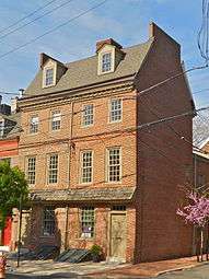 758 South Front Street
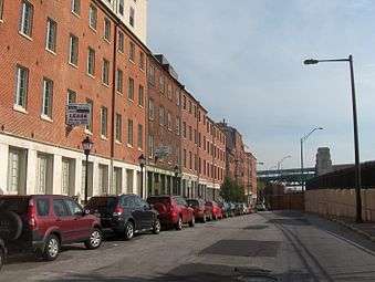 North Front Street, looking north towards Arch Street
Four sites listed on the National Register adjoin North Front Street: Elfreth's Alley, the Quaker City Dye Works, and two schools, the Thomas K. Finletter School and Olney High School.
 Olney High School
 Finletter School
 Quaker City Dye Works (view from Oxford Street)
References
| Wikimedia Commons has media related to Front Street (Philadelphia). |
- 1 2 Harry G. Kyriakodis (2011). "Philadelphia's Lost Waterfront". The History Press. Retrieved 30 May 2015.
- ↑ "world.nycsubway.org/ Photos 1-38 of 38". nycsubway.org. Retrieved 30 May 2015.
- ↑ "world.nycsubway.org/ Photos 1-29 of 29". nycsubway.org. Retrieved 30 May 2015.
- ↑ "National Historic Landmarks & National Register of Historic Places in Pennsylvania" (Searchable database). CRGIS: Cultural Resources Geographic Information System. Note: This includes Mary C. Means (June 1970). "National Register of Historic Places Registration Form: Widow Maloby's Tavern" (PDF). Retrieved 2012-07-03.
- ↑ ""National Historic Landmarks & National Register of Historic Places in Pennsylvania"" (Searchable database). CRGIS: Cultural Resources Geographic Information System. Note: This includes Mary C. Means (June 1970). "National Register of Historic Places Registration Form: Capt. Thomas Moore House" (PDF). Retrieved 2012-07-03.
- ↑ ""National Historic Landmarks & National Register of Historic Places in Pennsylvania"" (Searchable database). CRGIS: Cultural Resources Geographic Information System. Note: This includes Mary C. Means (June 1970). "National Register of Historic Places Registration Form: Nathaniel Irish House" (PDF). Retrieved 2012-07-03.
Coordinates: 39°54′50″N 75°08′56″W / 39.914°N 75.149°W