Front Royal, Virginia
| Front Royal, Virginia | ||
|---|---|---|
| Town | ||
| Town of Front Royal | ||
|
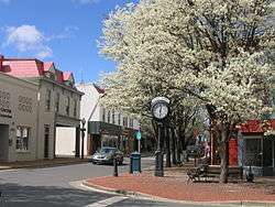
Main Street in Front Royal, April 2009. | ||
| ||
| Nickname(s): Canoe Capital of Virginia | ||
 Front Royal  Front Royal  Front Royal | ||
| Coordinates: 38°56′N 78°12′W / 38.933°N 78.200°WCoordinates: 38°56′N 78°12′W / 38.933°N 78.200°W | ||
| Country | United States | |
| State | Virginia | |
| County | Warren | |
| Founded | 1788 | |
| Government | ||
| • Mayor | Timothy W. Darr | |
| Area | ||
| • Total | 9.5 sq mi (24.6 km2) | |
| • Land | 9.3 sq mi (24.0 km2) | |
| • Water | 0.2 sq mi (0.6 km2) | |
| Elevation | 568 ft (173 m) | |
| Population (2010) | ||
| • Total | 14,440 | |
| • Density | 1,520/sq mi (586.99/km2) | |
| Time zone | Eastern (EST) (UTC-5) | |
| • Summer (DST) | EDT (UTC-4) | |
| ZIP code | 22630 | |
| Area code(s) | 540 | |
| FIPS code | 51-29968[1] | |
| GNIS feature ID | 1498480[2] | |
| Website | http://www.frontroyalva.com | |
Front Royal is a town in Warren County, Virginia, United States. The population was 14,440 at the 2010 census.[3] It is the county seat of Warren County.[4]
History
The entire Shenandoah Valley including the area to become Front Royal was annexed and claimed for hunting by the Iroquois Confederation during the later Beaver Wars, by 1672. Some bands of the Shawnee settled in the area as client groups to the Iroquois and alternately to the Cherokee after 1721. The Iroquois formally sold their entire claim east of the Alleghenies to the Virginia Colony at the Treaty of Lancaster in 1744.[5] Front Royal, originally settled in 1754 under the name LeHewtown, had been known to European explorers as early as the 1670s, and the nearby settlement of Chester's Ferry was in existence by 1736. The town also had a well-known nickname by the 1790s, "Helltown," due to the many livestock wranglers and boatmen on the Shenandoah coming through the area, who came into town looking for alcohol. It was incorporated as "Front Royal" in 1788.
Rail service was established in 1854 with the construction of the Alexandria, Orange and Manassas Gap Railroad between Manassas and Riverton. This line was soon extended to Strasburg in time to become a factor in the Battle of Front Royal on May 23, 1862 and throughout the Civil War. Lumber, agriculture, manufacturing and grain mills provided employment in the region for decades after the Civil War.
Origin of name
Several theories regarding the origins of the name "Front Royal" have been suggested.
A common theory is that the town was named for a giant oak tree – the "Royal" Tree of England – that stood in the public square during colonial days where Chester and Main Streets now join. It was there that the local militia were drilled. During drills, a frequent command given by the drill sergeant was, "front the Royal Oak!" The command was repeated and eventually shortened to simply "Front Royal".[6][7] This theory is supported by a bulletin published by the United States Geological Survey in 1905, which states that the town was first known as Royal Oak, with the current name being derived from the commands of a confused colonel.[8]
A second account holds that when local militia were stationed around the town during the American Revolution, the sentry would call out "Front", to which the required entry password was to respond "Royal". Eventually their military post became known as "Camp Front Royal".[6][9]
A third version holds that, in early decades of European settlement, the area was referred to in French as "le front royal", meaning the British frontier. French settlers, trappers, and explorers in the Ohio Territory of the mid-18th century were referring to the land grant made by King Charles II, then in control of Thomas, Lord Fairfax, Baron of Cameron. In English, "le front royal" is translated to the "Royal Frontier". The British themselves may have called the area "Front Royal" after 1763, when they set the so-called Proclamation Line along the spine of the Alleghenies to demarcate the settled portion of the colonies from the Indian Reserve in the interior.
National Register of Historic Places
Within Front Royal, the following buildings, properties and districts are listed on the National Register of Historic Places:[10]
Geography
Front Royal is approximately 76 miles (122 km) west of Washington, D.C.
According to the 2010 United States Census, the town has a total area of 9.5 square miles (24.6 km2), of which 9.3 square miles (24.1 km2) is land and 0.2 square miles (0.5 km2) (2.52%) is water. In 2014 the town annexed additional land, increasing the town's total land area to 10.5 square miles (27.2 km2).
Front Royal is located at the confluence of the North and South Forks of the Shenandoah River.[11]
Demographics
| Historical population | |||
|---|---|---|---|
| Census | Pop. | %± | |
| 1850 | 504 | — | |
| 1860 | 807 | 60.1% | |
| 1870 | 705 | −12.6% | |
| 1880 | 829 | 17.6% | |
| 1890 | 868 | 4.7% | |
| 1900 | 1,005 | 15.8% | |
| 1910 | 1,133 | 12.7% | |
| 1920 | 1,404 | 23.9% | |
| 1930 | 2,424 | 72.6% | |
| 1940 | 3,831 | 58.0% | |
| 1950 | 8,115 | 111.8% | |
| 1960 | 7,949 | −2.0% | |
| 1970 | 8,211 | 3.3% | |
| 1980 | 11,126 | 35.5% | |
| 1990 | 11,880 | 6.8% | |
| 2000 | 13,589 | 14.4% | |
| 2010 | 14,440 | 6.3% | |
| Est. 2015 | 15,070 | [12] | 4.4% |
As of the census[1] of 2000, there were 13,589 people, 5,425 households, and 3,585 families residing in the town. The population density was 1,464.9 people per square mile (565.4/km²). There were 5,752 housing units at an average density of 620.1 per square mile (239.3/km²). The racial makeup of the town was 88.31% White, 8.68% African American, 0.28% Native American, 0.63% Asian, 0.04% Pacific Islander, 0.66% from other races, and 1.40% from two or more races. Hispanic or Latino of any race were 2.13% of the population.
There were 5,425 households out of which 32.2% had children under the age of 18 living with them, 46.8% were married couples living together, 14.1% had a female householder with no husband present, and 33.9% were non-families. 28.9% of all households were made up of individuals and 12.5% had someone living alone who was 65 years of age or older. The average household size was 2.46 and the average family size was 3.01.
In the town the population was spread out with 25.7% under the age of 18, 8.2% from 18 to 24, 28.7% from 25 to 44, 22.8% from 45 to 64, and 14.6% who were 65 years of age or older. The median age was 37 years. For every 100 females there were 89.9 males. For every 100 females age 18 and over, there were 86.0 males.
The median income for a household in the town was $34,786, and the median income for a family was $42,675. Males had a median income of $32,373 versus $24,182 for females. The per capita income for the town was $17,901. About 9.1% of families and 14.8% of the population were below the poverty line, including 15.2% of those under age 18 and 13.2% of those age 65 or over.
Like many outer suburbs, Front Royal is facing the challenge of providing jobs to its community and preventing a slide into being a bedroom community. It also faces tensions between long-time residents, recent (10–20 years ago) arrivals and more affluent newly arrived residents, many of whom commute daily to Washington, D.C. and Northern Virginia. This struggle was reflected in Centex's huge 1,862-home "The Villages at Twin Rivers" proposal, which sought to transform 579 agriculturally zoned acres just outside the town into a residential district. The proposal was large enough that Centex is offering to build a new interchange on Interstate 66 and help fund a new elementary school. However, in late 2006, Centex scaled back its plans and is no longer offering to build an elementary school.
Government
Front Royal is governed by a mayor and six-member town council with four-year terms. The current government of Front Royal, as of January 2015,[14][15] is listed below.
Mayor
- Timothy W. Darr
Town Council
- Hollis L. Tharpe
- Bébhinn C. Egger
- Bret W. Hrbek
- Eugene R. Tewalt
- John P. Connolly
Appointed Positions
Education

Primary and secondary schools
- A.S. Rhodes Elementary School
- Blue Ridge Technical Center
- E.W. Morrison Elementary School
- Hilda J. Barbour Elementary School
- Leslie Fox Keyser Elementary School
- Ressie Jeffries Elementary School
- Warren County Middle School
- Brighter Futures Learning Community
- Mountain Vista Governor's School
- Skyline High School
- Warren County High School
Colleges and universities
- Smithsonian-Mason School of Conservation.[20]
Public libraries
- Samuels Public Library
Arts and culture
Points of interest


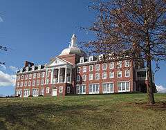
Front Royal is the home of Randolph-Macon Academy (founded 1892) which features an Air Force JROTC program. Front Royal is also the home of Christendom College and the Smithsonian Conservation Biology Institute (SCBI). Along with these institutions are the two rival high schools, Skyline High School and Warren County High School.
Commercially, Front Royal hosts the Virginia Inland Port, a U.S. Customs-designated port of entry, situated on U.S. Route 522.[21]
Front Royal is home to the 440-acre (1.8 km2) Avtex Fibers Superfund Site. Once Virginia's largest Superfund site, remediation activities at this former rayon manufacturing facility have been ongoing since 1989. The site is intended to eventually house a 175-acre (0.71 km2) eco-friendly office park, 30 acres (120,000 m2) of soccer fields, and 240 acres (0.97 km2) of conservancy park along the Shenandoah River. One of the reasons why Avtex shut down was the plant's emissions of polychlorinated biphenyls (PCBs) into the nearby Shenandoah River.[22][23]
Front Royal is also home to the U.S. Customs and Border Protection's Canine Center Front Royal (CCFR), formerly known as the Canine Enforcement Training Center (CETC).[24] This facility has trained dogs and their handlers in various detection abilities for federal and law enforcement agencies since 1974.[25]
Important tourist attractions include Skyline Caverns, the northern entrance to Shenandoah National Park, and Skyline Drive, which were both created during the Great Depression. It also has a large number of American Civil War attractions, both in the town and the surrounding Shenandoah Valley.
The Front Royal Cardinals baseball team joined the Valley League in 1984. Games are played in Bing Crosby Stadium. Bing Crosby helped raise funds for the building of the original stadium by arranging for his film Riding High to have its world premiere in Front Royal on April 1, 1950. Crosby’s initial involvement came about on April 30, 1948 when after acting as grand marshal of the Grand Feature Parade of the 21st. Shenandoah Apple Blossom Festival in Winchester, Virginia, he went on to Front Royal where he sang on the courthouse steps as part of a concert to help raise money for a new stadium. Bing was the first contributor to the Front Royal Recreation Center Building Fund when he donated $1,000. On April 1, 1950, Front Royal celebrated “Bing Crosby Day” and starting at 11 a.m., Crosby led a two-hour parade through the streets in front of a crowd of 20,000 to Recreation Park for the dedication of the baseball stadium. Park Theater was the venue for the official world premiere of Riding High at 8:30 p.m. where Crosby entertained the audience with several songs. During his appearance at the Park Theater, Bing wrote out a personal check for $3,595 to bring the gross receipts of the day to $15,000.[26]
In 1953, Frank Nesbitt coached a Little League team from Front Royal which came in 3rd in the world tournament. Freddie Moore was one of the players on that team, and later became active in Front Royal Little League. After Moore died of cancer one of Front Royal's Little League fields was named in his honor.
The Confederate Museum on Chester Street has many interesting artifacts from the 1860s, as have the museum buildings of the Warren Heritage Society, the Ivy Lodge (c. 1859), the Belle Boyd Cottage (c. 1836) and the Balthis House (c. 1788).
Front Royal was designated the "Canoe Capital of Virginia" in February 1999.[27]
Media
Three radio stations and two weekly newspapers are based and licensed to Front Royal.
On radio, FM stations WZRV and WFQX are licensed to the town. WZRV is actually based in Front Royal, while WFQX is based in nearby Winchester. Also, on radio, AM station WFTR is based and licensed to the town.
The Northern Virginia Daily is a daily newspaper serving the area. Weekly newspapers The Sherando Times and The Warren County Report are based in Front Royal. The Warren County Report serves Warren County, while The Sherando Times serves the Stephens City, Middletown, and Kernstown areas of nearby Frederick County, Virginia. The Warren Sentinel is the county's oldest newspaper, dating back over 150 years. It is published each Thursday.
Infrastructure
Transportation
- Front Royal Area Transit (FRAT) provides weekday transit for the town of Front Royal.
- Page County Transit provides weekday transit for the town of Luray and weekday service between Luray and Front Royal.
- Shenandoah Valley Commuter Bus previously offered weekday commuter bus service from Northern Shenandoah Valley including Warren County to Northern Virginia and Washington, D.C. including Arlington County and Fairfax County. Origination points in Warren County included Front Royal. The service was terminated in January 2011 due to declining revenues.
Notable People
- Darrell Whitmore, professional baseball player.
- Dana Allison, professional baseball player.
- C.E. Byrd, Virginia-born educator who established C.E. Byrd High School in Shreveport, Louisiana, began his teaching career in the 1880s in Front Royal.
References
- 1 2 "American FactFinder". United States Census Bureau. Retrieved January 31, 2008.
- ↑ "Front Royal". Geographic Names Information System. United States Geological Survey. Retrieved March 28, 2015.
- ↑ "Front Royal (town) QuickFacts from the US Census Bureau". Census.gov. Retrieved March 28, 2015.
- ↑ "Find a County". National Association of Counties. Retrieved June 7, 2011.
- ↑ Hofstra, Warren (2005). The Planting of New Virginia: Settlement and Landscape in the Shenandoah Valley. Baltimore, MD: The Johns Hopkins University Press. pp. 10–12. ISBN 0801882710.
- 1 2 Federal Writers' Project (1952). Virginia: A Guide to the Old Dominion. US History Publishers. p. 443. ISBN 1603540458. Retrieved February 8, 2015.
- ↑ Lillard, David Edwin (2002). Appalachian Trail names: Origins of place names along the AT. Mechanicsburg, PA: Stackpole Books. p. 42. ISBN 081172672X. Retrieved February 8, 2015.
- ↑ Gannett, Henry (1905). The Origin of Certain Place Names in the United States, Issue 258 of the U.S. Geological Survey Bulletin. U.S. Government Printing Office. p. 132. Retrieved December 11, 2015.
- ↑ Willis, Carrie Hunter; Walker, Etta Belle (1940). Legends of the Skyline Drive and the Great Valley of Virginia. Dietz Press. pp. 35–36. Retrieved February 5, 2015.
- ↑ National Park Service (2010-07-09). "National Register Information System". National Register of Historic Places. National Park Service.
- ↑ Virginia Department of Game and Inland Fisheries. "Shenandoah River – South Fork". Virginia.gov. Retrieved March 28, 2015.
- ↑ "Annual Estimates of the Resident Population for Incorporated Places: April 1, 2010 to July 1, 2015". Retrieved July 2, 2016.
- ↑ "Census of Population and Housing". Census.gov. Retrieved June 4, 2015.
- ↑ "About the Mayor". Town of Front Royal (FrontRoyalVA.com). March 7, 2011. Retrieved January 25, 2015.
- ↑ "Town Council". Town of Front Royal (FrontRoyalVA.com). January 7, 2015. Retrieved January 25, 2015.
- ↑ "Town Manager". Town of Front Royal (FrontRoyalVA.com). November 18, 2014. Retrieved January 25, 2015.
- ↑ "Town Attorney". Town of Front Royal (FrontRoyalVA.com). August 6, 2013. Retrieved January 25, 2015.
- ↑ "Clerk of Council". Town of Front Royal (FrontRoyalVA.com). January 7, 2015. Retrieved January 25, 2015.
- ↑ "Police Department Administration". Town of Front Royal (FrontRoyalVA.com). October 28, 2014. Retrieved January 25, 2015.
- ↑ National Zoological Park. "Smithsonian-Mason School of Conservation Facilities and Program Fact Sheet". Smithsonian. Retrieved 17 October 2015.
- ↑ The Port of Virginia. "Virginia Inland Port (VIP)". Portofvirginia.com. Retrieved March 28, 2015.
- ↑ "Avtex Fibers Superfund Site – Community Homepage". Avtexfibers.com. Retrieved March 28, 2015.
- ↑ U.S. Environmental Protection Agency (January 2015). "Mid-Atlantic Superfund – Avtex Fibers, Inc.". Epa.gov. Retrieved March 28, 2015.
- ↑ "Canine Program History". Cbp.gov. Retrieved March 28, 2015.
- ↑ Brian Handwerk (July 12, 2002). ""Detector Dogs" Sniff Out Smugglers for U.S. Customs". News.nationalgeographic.com. Retrieved March 28, 2015.
- ↑ Macfarlane, Malcolm. "Bing Crosby - Day by Day". BING magazine. International Club Crosby. Retrieved January 25, 2016.
- ↑ "The Winding Road to the Canoe Capital of Virginia". Warren County Chamber of Commerce. Archived from the original on February 9, 2012. Retrieved March 26, 2015.
External links
| Wikimedia Commons has media related to Front Royal, Virginia. |
| Wikivoyage has a travel guide for Front Royal. |
- Front Royal Tourism Info
- Town of Front Royal
- Front Royal/Warren County Chamber of Commerce
- Warren Heritage Society
- News story about the forefathers of Front Royal
Municipalities and communities of Warren County, Virginia, United States | ||
|---|---|---|
| Town |  | |
| CDPs | ||
| Unincorporated communities |
| |
| Footnotes | ‡This populated place also has portions in an adjacent county or counties | |