Frisange
| Frisange Fréiseng | ||
|---|---|---|
| Commune | ||
|
Town hall | ||
| ||
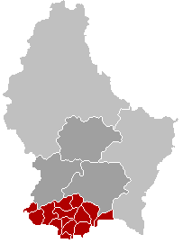
 Map of Luxembourg with Frisange highlighted in orange, and the canton in dark red | ||
| Coordinates: 49°30′55″N 6°11′20″E / 49.5153°N 6.1889°ECoordinates: 49°30′55″N 6°11′20″E / 49.5153°N 6.1889°E | ||
| Country |
| |
| Canton | Esch-sur-Alzette | |
| Government | ||
| • Mayor | Marie-Louise Aulner | |
| Area | ||
| • Total | 18.43 km2 (7.12 sq mi) | |
| Area rank | 64 of 105 | |
| Highest elevation | 293 m (961 ft) | |
| • Rank | 103rd of 105 | |
| Lowest elevation | 224 m (735 ft) | |
| • Rank | 38th of 105 | |
| Population (2014) | ||
| • Total | 4,023 | |
| • Rank | 35th of 105 | |
| • Density | 220/km2 (570/sq mi) | |
| • Density rank | 32nd of 105 | |
| Time zone | CET (UTC+1) | |
| • Summer (DST) | CEST (UTC+2) | |
| LAU 2 | LU00010005 | |
| Website | frisange.lu | |


Frisange (Luxembourgish: Fréiseng, German: Frisingen) is a commune and town in southern Luxembourg. It is part of the canton of Esch-sur-Alzette, which is part of the district of Luxembourg.
As of 2005, the town of Frisange, which lies in the north of the commune, has a population of 1,302. Other towns within the commune include Aspelt and Hellange.

The church
Sister cities
Frisange is twinned with:
External links
-
 Media related to Frisange at Wikimedia Commons
 |
Roeser | Weiler-la-Tour | | |
| |
Dalheim (G) | |||
| ||||
| | ||||
| Zoufftgen (FR-57) | Hagen, Évrange, Basse-Rentgen (all in FR-57) | Mondorff (FR-57) |
 | ||
This article is issued from Wikipedia - version of the 12/1/2016. The text is available under the Creative Commons Attribution/Share Alike but additional terms may apply for the media files.