Friesland Ridge
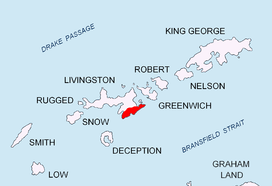


Friesland Ridge (Hrebet Frisland \'hre-bet 'fris-land\) is a ridge on Livingston Island in the South Shetlands, part of the Tangra Mountains. The summit, Mount Friesland, which rises to 1,700 metres (5,600 ft), is the northwesternmost of the ridge’s six main peaks. The summit elevation was estimated at 1,684 metres (5,525 ft) by a 1995/96 Bulgarian survey;[1] the present figure was produced by a 2003 Australian GPS survey,[2][3] and confirmed by the Bulgarian survey Tangra 2004/05.
First ascent of the summit Mount Friesland by the Catalans Francesc Sàbat and Jorge Enrique from Juan Carlos I Base on 30 December 1991.
The feature takes its name from Mount Friesland.
Location
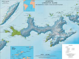
The midpoint of the ridge is located at 62°42′15″S 60°13′30″W / 62.70417°S 60.22500°WCoordinates: 62°42′15″S 60°13′30″W / 62.70417°S 60.22500°W (UK Directorate of Overseas Surveys mapping in 1968, partial mapping by the Spanish Servicio Geográfico del Ejército in 1991, and Bulgarian mapping in 2005 from topographic surveys in 1995/96 and 2004/05).
Maps
- L.L. Ivanov. Livingston Island: Central-Eastern Region. Scale 1:25000 topographic map. Sofia: Antarctic Place-names Commission of Bulgaria, 1996.
- S. Soccol, D. Gildea and J. Bath. Livingston Island, Antarctica. Scale 1:100000 satellite map. The Omega Foundation, USA, 2004.
- L.L. Ivanov et al. Antarctica: Livingston Island and Greenwich Island, South Shetland Islands. Scale 1:100000 topographic map. Sofia: Antarctic Place-names Commission of Bulgaria, 2005.
- L.L. Ivanov. Antarctica: Livingston Island and Greenwich, Robert, Snow and Smith Islands. Scale 1:120000 topographic map. Troyan: Manfred Wörner Foundation, 2009. ISBN 978-954-92032-6-4
Notes
- ↑ L.L. Ivanov. Livingston Island: Central-Eastern Region. Scale 1:25000 topographic map. Sofia: Antarctic Place-names Commission of Bulgaria, 1996.
- ↑ D. Gildea. Antarctica, Antarctic Peninsula, Livingston Island, South Shetland Islands, Second Ascent of Mt. Friesland and New Altitude. American Alpine Journal, 2004. Vol. 46, Issue 78, pp. 329–331.
- ↑ Expedition Omega Livingston 2003. The Omega Foundation, USA, 2003.
References
- Friesland Ridge. SCAR Composite Gazetteer of Antarctica.
- Bulgarian Antarctic Gazetteer. Antarctic Place-names Commission. (details in Bulgarian, basic data in English)
This article includes information from the Antarctic Place-names Commission of Bulgaria which is used with permission.