Friedrichsfelde
| Friedrichsfelde | ||
|---|---|---|
| Quarter of Berlin | ||
|
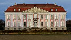
Friedrichsfelde Castle | ||
| ||
 Friedrichsfelde | ||
Location of Friedrichsfelde in Lichtenberg district and Berlin  | ||
| Coordinates: 52°30′21″N 13°31′09″E / 52.50583°N 13.51917°ECoordinates: 52°30′21″N 13°31′09″E / 52.50583°N 13.51917°E | ||
| Country | Germany | |
| State | Berlin | |
| City | Berlin | |
| Borough | Lichtenberg | |
| Founded | 1265 | |
| Area | ||
| • Total | 5.55 km2 (2.14 sq mi) | |
| Population (2008-06-30) | ||
| • Total | 50,010 | |
| • Density | 9,000/km2 (23,000/sq mi) | |
| Time zone | CET/CEST (UTC+1/+2) | |
| Postal codes | (nr. 1101) 10315, 10319 | |
| Vehicle registration | B | |
| Website | Official website | |

Friedrichsfelde is a German locality (Ortsteil) within the borough (Bezirk) of Lichtenberg, Berlin.
History
The locality was first mentioned in a document of 1265 with the name of Rosenfelde. In 1699 it was renamed Friedrichsfelde after the Prince-Elector Frederick III of Brandenburg.[1] Until 1920 it was an autonomous municipality of the former Niederbarnim district, merged into Berlin with the "Greater Berlin Act".[2]
Geography
Located in eastern suburb of Berlin, Friedrichsfelde borders with the localities of Lichtenberg, Rummelsburg, Karlshorst, Marzahn and Biesdorf (both in Marzahn-Hellersdorf district). In its south-eastern corner is situated the "Tierpark Berlin", the second zoo of the city.
Transport
As urban rail, Friedrichsfelde is crossed both by S-Bahn and U-Bahn. The stations serving the locality are Friedrichsfelde Ost (lines S5, S7, S75), Friedrichsfelde (U5), Tierpark (U5) and partly Rummelsburg (S3). The quarter is also served by the tramway lines M17, 27 and 37 and traversed by the federal highways B1 and B5.
Photogallery
_-_west.jpg) B1/B5 road across the locality
B1/B5 road across the locality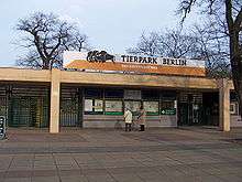 Main entrance of Tierpark
 Catholic church
References
External links
![]() Media related to Friedrichsfelde at Wikimedia Commons
Media related to Friedrichsfelde at Wikimedia Commons
- (German) Friedrichsfelde official website
- (German) Friedrichsfelde Event- & Informationportal for all citizens of Friedrichsfelde
- (German) Friedrichsfelde page on www.berlin.de
| |