Freeport, Kansas
| Freeport, Kansas | |
|---|---|
| City | |
 Location within Harper County and Kansas | |
 KDOT map of Harper County (legend) | |
| Coordinates: 37°11′50″N 97°51′23″W / 37.19722°N 97.85639°WCoordinates: 37°11′50″N 97°51′23″W / 37.19722°N 97.85639°W | |
| Country | United States |
| State | Kansas |
| County | Harper |
| Area[1] | |
| • Total | 0.20 sq mi (0.52 km2) |
| • Land | 0.20 sq mi (0.52 km2) |
| • Water | 0 sq mi (0 km2) |
| Elevation | 1,335 ft (407 m) |
| Population (2010)[2] | |
| • Total | 5 |
| • Estimate (2015)[3] | 5 |
| • Density | 25/sq mi (9.6/km2) |
| Time zone | Central (CST) (UTC-6) |
| • Summer (DST) | CDT (UTC-5) |
| ZIP code | 67049 |
| Area code | 620 |
| FIPS code | 20-24725 [4] |
| GNIS feature ID | 0470290 [5] |
Freeport is a city in Harper County, Kansas, United States. As of the 2010 census, the city population was 5,[6] making it the smallest incorporated city in the state of Kansas.
History
Freeport was founded in 1885.[7] It was located on the Missouri Pacific Railway.[8]
The first post office in Freeport was established in September 1885.[9]
Geography
Freeport is located at 37°11′50″N 97°51′23″W / 37.19722°N 97.85639°W (37.197234, -97.856481).[10] According to the United States Census Bureau, the city has a total area of 0.20 square miles (0.52 km2), all of it land.[1]
Demographics
| Historical population | |||
|---|---|---|---|
| Census | Pop. | %± | |
| 1890 | 138 | — | |
| 1900 | 83 | −39.9% | |
| 1910 | 161 | 94.0% | |
| 1920 | 56 | −65.2% | |
| 1930 | 105 | 87.5% | |
| 1940 | 67 | −36.2% | |
| 1950 | 30 | −55.2% | |
| 1960 | 31 | 3.3% | |
| 1970 | 21 | −32.3% | |
| 1980 | 12 | −42.9% | |
| 1990 | 8 | −33.3% | |
| 2000 | 6 | −25.0% | |
| 2010 | 5 | −16.7% | |
| Est. 2015 | 5 | [3] | 0.0% |
| U.S. Decennial Census | |||
2010 census
As of the census[2] of 2010, there were 5 people, 3 households, and 2 families residing in the city. The population density was 25.0 inhabitants per square mile (9.7/km2). There were 4 housing units at an average density of 20.0 per square mile (7.7/km2). The racial makeup of the city was 80.0% White and 20.0% Native American.
There were 3 households of which 66.7% were married couples living together and 33.3% were non-families. 33.3% of all households were made up of individuals. The average household size was 1.67 and the average family size was 2.00.
The median age in the city was 66.5 years. 0.0% of residents were under the age of 18; 20% were between the ages of 18 and 24; 0.0% were from 25 to 44; 20% were from 45 to 64; and 60% were 65 years of age or older. The gender makeup of the city was 60.0% male and 40.0% female.
2000 census
As of the census[4] of 2000, there were 6 people, 3 households, and 3 families residing in the city. The population density was 31.5 people per square mile (12.2/km²). There were 5 housing units at an average density of 26.3 per square mile (10.2/km²). The racial makeup of the city was 100.00% White.
There were 3 households out of which none had persons under the age of 18 living with them, 66.7% were married couples living together, and 33.3% had a female householder with no husband present. The average household size was 2.00 and the average family size was 2.00.
In the city the population was spread out with 33.3% from 45 to 64, and 66.7% who were 65 years of age or older. The median age was 66 years. For every 100 females there were 100 males. For every 100 females age 18 and over, there were 100 males.
The median income for a household in the city was $31,250, and the median income for a family was $31,250. Males had a median income of $0 versus $0 for females. The per capita income for the city was $14,590. None of the population and none of the families were below the poverty line.
References
- 1 2 "US Gazetteer files 2010". United States Census Bureau. Retrieved 2012-07-06.
- 1 2 "American FactFinder". United States Census Bureau. Retrieved 2012-07-06.
- 1 2 "Annual Estimates of the Resident Population for Incorporated Places: April 1, 2010 to July 1, 2015". Retrieved July 2, 2016.
- 1 2 "American FactFinder". United States Census Bureau. Retrieved 2008-01-31.
- ↑ "US Board on Geographic Names". United States Geological Survey. 2007-10-25. Retrieved 2008-01-31.
- ↑ "2010 City Population and Housing Occupancy Status". U.S. Census Bureau. Retrieved March 6, 2011.
- ↑ "12 U.S. places where your visit could double the population". Mother Nature Network. Retrieved 2 May 2014.
- ↑ Kansas State Historical Society (1916). Biennial Report of the Board of Directors of the Kansas State Historical Society. Kansas State Printing Plant. p. 202.
- ↑ "Kansas Post Offices, 1828-1961 (archived)". Kansas Historical Society. Archived from the original on October 9, 2013. Retrieved 11 June 2014.
- ↑ "US Gazetteer files: 2010, 2000, and 1990". United States Census Bureau. 2011-02-12. Retrieved 2011-04-23.
External list
| Wikimedia Commons has media related to Freeport, Kansas. |
- City
- Schools
- USD 359, local school district
- Maps
- Freeport City Map, KDOT
Municipalities and communities of Harper County, Kansas, United States | ||
|---|---|---|
| Cities | 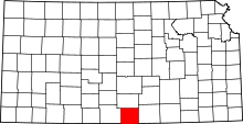 | |
| Unincorporated communities | ||
| Townships | ||
| Ghost town | ||