Freeman Municipal Airport
| Freeman Municipal Airport | |||||||||||||||||||||||
|---|---|---|---|---|---|---|---|---|---|---|---|---|---|---|---|---|---|---|---|---|---|---|---|
|
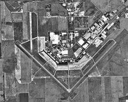
USGS 1998 orthophoto | |||||||||||||||||||||||
| IATA: SER – ICAO: KSER – FAA LID: SER | |||||||||||||||||||||||
| Summary | |||||||||||||||||||||||
| Airport type | Public | ||||||||||||||||||||||
| Owner | Seymour Airport Authority | ||||||||||||||||||||||
| Serves | Seymour, Indiana | ||||||||||||||||||||||
| Elevation AMSL | 583 ft / 178 m | ||||||||||||||||||||||
| Coordinates | 38°55′29″N 085°54′30″W / 38.92472°N 85.90833°WCoordinates: 38°55′29″N 085°54′30″W / 38.92472°N 85.90833°W | ||||||||||||||||||||||
| Map | |||||||||||||||||||||||
 SER  SER Location of airport in Indiana/United States | |||||||||||||||||||||||
| Runways | |||||||||||||||||||||||
| |||||||||||||||||||||||
| Statistics (2009) | |||||||||||||||||||||||
| |||||||||||||||||||||||
Freeman Municipal Airport (IATA: SER[2], ICAO: KSER, FAA LID: SER) is a public use airport located two nautical miles (4 km) southwest of the central business district of Seymour, a city in Jackson County, Indiana, United States. It is owned by the Seymour Airport Authority.[1] This airport is included in the National Plan of Integrated Airport Systems for 2011–2015, which categorized it as a general aviation facility.[3]
History
Established by the United States Army Air force in 1942. Became first USAAF helicopter training school in June 1944. Black aviators, including a group of Tuskegee Airmen, trained at Freeman Field. In April 1945, black officers tried to integrate an officers' club resulting in what became known as the "Freeman Field Mutiny". The mutiny is generally regarded by historians of the Civil Rights Movement as an important step toward full integration of the armed forces and as a model for later efforts to integrate public facilities through civil disobedience.
After the end of World War II, Freeman AAF became a storage depot of many captured German and Italian aircraft (Operation Lusty). Training at the field had stopped and it became the site for the storage of American and foreign aircraft. Freeman Field was closed and declared surplus on December 30, 1946. It was deactivated in November 1948.
Facilities and aircraft
Freeman Municipal Airport covers an area of 2,100 acres (850 ha) at an elevation of 583 feet (178 m) above mean sea level. It has two asphalt paved runways: 14/32 is 5,502 by 100 feet (1,677 x 30 m) and 5/23 is 5,500 by 100 feet (1,676 x 30 m). It also has two unpaved turf runways: 18U/36U is 1,200 by 100 feet (366 x 30 m) and 9U/27U is 1,000 by 100 feet (305 x 30 m).[1]
For the 12-month period ending December 31, 2009, the airport had 13,127 aircraft operations, an average of 35 per day: 78% general aviation, 21% air taxi, and 1% military. At that time there were 66 aircraft based at this airport: 67% single-engine, 23% ultralight, 9% multi-engine, and 1% helicopter.[1]
References
- 1 2 3 4 FAA Airport Master Record for SER (Form 5010 PDF). Federal Aviation Administration. Effective November 15, 2012.
- ↑ "IATA Airport Code Search (SER: Seymour / Freeman Municipal)". International Air Transport Association. Retrieved December 24, 2012.
- ↑ "2011–2015 NPIAS Report, Appendix A" (PDF, 2.03 MB). National Plan of Integrated Airport Systems. Federal Aviation Administration. October 4, 2010. External link in
|work=(help)
External links
- Freeman Field Air Museum (OFFICIAL site for Freeman Field)
- FAA Terminal Procedures for SER, effective November 10, 2016
- Resources for this airport:
- FAA airport information for SER
- AirNav airport information for KSER
- ASN accident history for SER
- FlightAware airport information and live flight tracker
- SkyVector aeronautical chart for KSER