Franklin, New Hampshire
| Franklin, New Hampshire | ||
|---|---|---|
| City | ||
|
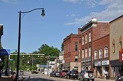
Central Street | ||
| ||
| Motto: "The Three Rivers City" | ||
 Location within Merrimack County, and the state of New Hampshire. | ||
| Coordinates: 43°26′39″N 71°38′51″W / 43.44417°N 71.64750°WCoordinates: 43°26′39″N 71°38′51″W / 43.44417°N 71.64750°W | ||
| Country | United States | |
| State | New Hampshire | |
| County | Merrimack | |
| Settled | 1764 | |
| Incorporated (Town) | 1828 | |
| Government | ||
| • Mayor | Ken Merrifield | |
| • City Council |
Ted Starkweather Anthony Giunta George Dzujna Doug Boyd Olivia Zink Bob Desrochers, Sr. Steve Barton Scott Clarenbach Jim Wells | |
| • City Manager | Elizabeth Dragon | |
| Area | ||
| • Total | 29.1 sq mi (75.4 km2) | |
| • Land | 27.3 sq mi (70.7 km2) | |
| • Water | 1.9 sq mi (4.8 km2) 6.31% | |
| Elevation | 310 ft (94 m) | |
| Population (2010) | ||
| • Total | 8,477 | |
| • Density | 311/sq mi (120.0/km2) | |
| Time zone | EST (UTC-5) | |
| • Summer (DST) | EDT (UTC-4) | |
| ZIP code | 03235 | |
| Area code(s) | 603 | |
| FIPS code | 33-27380 | |
| GNIS feature ID | 0873290 | |
| Website |
www | |

Franklin is a city in Merrimack County, New Hampshire, United States. At the 2010 census, the population was 8,477,[1] the lowest of any of New Hampshire's 13 cities. Franklin includes the village of West Franklin.
History
Situated at the confluence of the Pemigewasset and Winnipesaukee rivers that form the Merrimack River, the town was settled by Anglo-European colonists in 1764 and originally known as Pemigewasset Village. It was taken from portions of Salisbury, Andover, Sanbornton and Northfield. The name Franklin was adopted in 1820 in honor of statesman and founding father Benjamin Franklin. Water power from the falls helped it develop as a mill town.[2] It would incorporate as a town in 1828, and then as a city in 1895.
Daniel Webster was born in a section of Franklin that was then part of Salisbury. There is a state historic site located off Route 127 that preserves the famous orator's childhood home. As an adult, Webster owned "The Elms", a farm near the Merrimack River along present-day Route 3.
In 1943, the Army Corps of Engineers created the Franklin Falls Reservoir above Franklin by constructing the Franklin Falls Dam for flood control on the Pemigewasset River.
 Bird's eye view c. 1912
 Merrimack River in 1905
 Old High School in 1908
 Central Street in 1909
 Sulloway Mills c. 1910
 Daniel Webster birthplace c. 1910
 City Hall
 The library
Geography
Franklin is located at 43°26′49″N 71°39′25″W / 43.44694°N 71.65694°W (43.446956, -71.656966).[3]
According to the United States Census Bureau, the city has a total area of 29.1 square miles (75.4 km2), of which 27.3 square miles (70.7 km2) is land and 1.9 square miles (4.9 km2) is water, comprising 6.31% of the town.[4] It is drained by the Winnipesaukee, Pemigewasset and Merrimack rivers. Webster Lake is in the north. The highest point in Franklin is an unnamed summit near the northwestern corner of the city limits, where the elevation reaches approximately 1,370 feet (420 m) above sea level. Franklin lies fully within the Merrimack River watershed.[5]
U.S. Route 3 and New Hampshire Route 11 form Central Street, the main street of Franklin. Heading east, the two routes lead to Tilton and Laconia, New Hampshire. US 3 leads south to Boscawen and Concord, while NH 11 goes west to Andover and New London. New Hampshire Route 127 also passes through downtown Franklin, leading southwest to Salisbury and Contoocook, and north into Sanbornton. New Hampshire Route 3A leads north from West Franklin to Bristol.
Demographics
As of the census[6] of 2000, there were 8,405 people, 3,319 households, and 2,193 families residing in the city. The population density was 304.9 people per square mile (117.7/km²). There were 3,676 housing units at an average density of 133.4 per square mile (51.5/km²). The racial makeup of the city was 97.10% White, 0.38% African American, 0.27% Native American, 0.51% Asian, 0.01% Pacific Islander, 0.35% from other races, and 1.38% from two or more races. Hispanic or Latino of any race were 1.19% of the population.
There were 3,319 households out of which 32.3% had children under the age of 18 living with them, 46.3% were married couples living together, 14.2% had a female householder with no husband present, and 33.9% were non-families. 27.0% of all households were made up of individuals and 10.7% had someone living alone who was 65 years of age or older. The average household size was 2.47 and the average family size was 2.95.
In the city the population was spread out with 25.8% under the age of 18, 8.5% from 18 to 24, 28.4% from 25 to 44, 22.7% from 45 to 64, and 14.7% who were 65 years of age or older. The median age was 37 years. For every 100 females there were 94.1 males. For every 100 females age 18 and over, there were 87.5 males.
| Historical population | |||
|---|---|---|---|
| Census | Pop. | %± | |
| 1830 | 1,370 | — | |
| 1840 | 1,281 | −6.5% | |
| 1850 | 1,251 | −2.3% | |
| 1860 | 1,600 | 27.9% | |
| 1870 | 2,301 | 43.8% | |
| 1880 | 3,265 | 41.9% | |
| 1890 | 4,085 | 25.1% | |
| 1900 | 5,846 | 43.1% | |
| 1910 | 6,132 | 4.9% | |
| 1920 | 6,318 | 3.0% | |
| 1930 | 6,576 | 4.1% | |
| 1940 | 6,749 | 2.6% | |
| 1950 | 6,552 | −2.9% | |
| 1960 | 6,742 | 2.9% | |
| 1970 | 7,292 | 8.2% | |
| 1980 | 7,901 | 8.4% | |
| 1990 | 8,304 | 5.1% | |
| 2000 | 8,405 | 1.2% | |
| 2010 | 8,477 | 0.9% | |
| Est. 2015 | 8,450 | [7] | −0.3% |
The median income for a household in the city was $34,613, and the median income for a family was $41,698. Males had a median income of $32,318 versus $25,062 for females. The per capita income for the city was $17,155. About 8.9% of families and 12.9% of the population were below the poverty line, including 18.2% of those under age 18 and 9.7% of those age 65 or over.
Education
Sites of interest
- Sulphite Railroad Bridge (the "upside-down" railroad bridge)
- Daniel Webster Birthplace State Historic Site
Notable people
- Jedh Barker (1945–1967), marine; received the Medal of Honor
- Vaughn Blanchard, track and field athlete
- Walter Bradford Cannon (1871–1945), physiologist
- Warren F. Daniell, industrialist and US congressman
- John King Fairbank (1907–1991), historian (summer resident)
- Robert M. Leach, US congressman
- Jenna Lewis (b. 1977), contestant on Survivor (2000)
- G. W. Pierce (1872–1956), physicist
- Arthur Schlesinger, Jr. (1917–2007), historian (summer resident)
- Daniel Webster (1782–1852), Secretary of State, US senator and congressman
References
- ↑ United States Census Bureau, American FactFinder, 2010 Census figures. Retrieved March 23, 2011.
- ↑ Coolidge, Austin J.; John B. Mansfield (1859). A History and Description of New England. Boston, Massachusetts. pp. 497–499.
- ↑ "US Gazetteer files: 2010, 2000, and 1990". United States Census Bureau. 2011-02-12. Retrieved 2011-04-23.
- ↑ "Geographic Identifiers: 2010 Demographic Profile Data (G001) - Franklin city, New Hampshire". U.S. Census Bureau American Factfinder. Retrieved November 14, 2011.
- ↑ Foster, Debra H.; Batorfalvy, Tatianna N.; Medalie, Laura (1995). Water Use in New Hampshire: An Activities Guide for Teachers. U.S. Department of the Interior and U.S. Geological Survey.
- ↑ "American FactFinder". United States Census Bureau. Retrieved 2008-01-31.
- ↑ "Annual Estimates of the Resident Population for Incorporated Places: April 1, 2010 to July 1, 2015". Retrieved July 2, 2016.
- ↑ "Census of Population and Housing". Census.gov. Retrieved June 4, 2015.
External links
| Wikimedia Commons has media related to Franklin, New Hampshire. |
| Wikisource has the text of the 1911 Encyclopædia Britannica article Franklin (New Hampshire). |
- City of Franklin official website
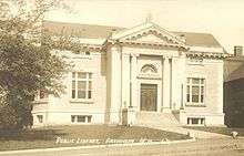
- Franklin Public Library
- Franklin Historical Society
- Franklin Opera House
- Lakes Region Snowmobile Club
- New Hampshire Economic and Labor Market Information Bureau Profile
Municipalities and communities of Merrimack County, New Hampshire, United States | ||
|---|---|---|
| Cities | 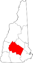 | |
| Towns | ||
| CDPs | ||
| Other unincorporated communities | ||
| Footnotes | ‡This populated place also has portions in an adjacent county or counties | |