Frank, Alberta
| Frank | |
|---|---|
 Frank Location of Frank in Alberta | |
| Coordinates: 49°36′10″N 114°24′28″W / 49.6028°N 114.4078°WCoordinates: 49°36′10″N 114°24′28″W / 49.6028°N 114.4078°W | |
| Country |
|
| Province |
|
| Census division | No. 15 |
| Specialized municipality | Municipality of Crowsnest Pass |
| Government | |
| • Type | Unincorporated |
| • Governing body | Municipality of Crowsnest Pass Council |
| Population (2011)[1] | |
| • Total | 112 |
| Time zone | MST (UTC−7) |
| • Summer (DST) | MDT (UTC−6) |
Frank is an urban community in the Rocky Mountains within the Municipality of Crowsnest Pass in southwest Alberta, Canada. It was formerly incorporated as a village prior to 1979 when it amalgamated with four other municipalities to form Crowsnest Pass.
History
In 1901, American entrepreneurs Sam Gebo and Henry Frank developed the first of many coal mines in the Crowsnest Pass, in the base of Turtle Mountain. In May that year the first buildings were erected in the new community of Frank, located on flat land between the Canadian Pacific Railway tracks and the mine. The town’s grand opening on September 10, 1901 was an all-day event that included sporting competitions (with engraved medals for the victors), tours of the mine, a banquet, and a dance. Two special trains brought in the guests, and the gourmet food (including a ton of ice cream). Henry Frank presided over the event, which was attended by the premier Frederick W. A. G. Haultain, his public works minister and federal Minister of the Interior, Clifford Sifton.[2] Frank became the first incorporated village in the Pass and by 1903 served 1000 people with two dozen businesses and services, a two-story brick school and a regional post office.
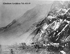
The Frank Slide of 1903 destroyed much of the mine’s infrastructure, several rural businesses, and seven houses on the outskirts of Frank, killing 70-90 people. However the mine reopened within weeks and the rail line was soon re-established through the slide path. Frank continued to boom, and in 1905-06 a new residential subdivision was developed out north of the tracks to keep pace with mine production, a new zinc smelter, and a new three-story hotel (Rocky Mountains Sanatorium) close to a cold sulphur spring. A small zoo was built near the hotel.
However a period of decline soon followed. Due to market forces the zinc smelter never operated, and was converted to an ice skating arena. Fears of a second slide led to a government-ordered closure of the south townsite in 1911, and over the next several years its buildings were torn down or moved. The 1905 subdivision remained, but Frank ceased to be an important centre after the mine closed temporarily in 1912 and permanently in 1917. The Sanatorium, converted to a military hospital in 1917, was torn down in 1928 after a period of abandonment. The post office was finally closed in 1968[3]
Today, Frank is a quiet residential community of about 200 people, with few hints of its promising past. It is the smallest of the five towns that amalgamated into the Municipality of Crowsnest Pass in 1979. The Frank Slide was designated a Provincial Historical Resource in 1977, and in 1985 the provincial government opened a major interpretive centre in Frank that explains the Frank Slide and the coal mining history of the region. The site of the original Frank townsite is now an industrial park, and many of the historic buildings in the north subdivision are gone, including Gebo’s stately mansion and the Catholic Church blown down by wind in 1917. But there are a few houses that are over a hundred years old, and you can still see pieces of century-old wood-stave water pipes in Gold Creek, part of the foundation of the zinc plant (and the tunnel that connected it to its hilltop chimney), and an antique fire hydrant in the old closed townsite.
Demographics
As a designated place in the 2011 Census, Frank had a population of 112 living in 50 of its 62 total dwellings, a -11.8% change from its 2006 population of 127. With a land area of 0.16 km2 (0.062 sq mi), it had a population density of 700/km2 (1,810/sq mi) in 2011.[1]
According to the 2006 Census of Canada, the population of Frank is 263, which represents 5% of the overall population of the Municipality of Crowsnest Pass (5,749).[4]
See also
References
- 1 2 "Population and dwelling counts, for Canada, provinces and territories, and designated places, 2011 and 2006 censuses (Alberta)". Statistics Canada. 2012-02-08. Retrieved 2012-04-07.
- ↑ Anderson, Frank W (1968). The Frank Slide Story. Calgary: Frontiers Unlimited. p. 4.
- ↑ Crowsnest Pass Historical Society (1979). Crowsnest and its people. Coleman: Crowsnest Pass Historical Society. p. 40. ISBN 0-88925-046-4.
- ↑ Alberta Municipal Affairs (2009-09-15). "Alberta 2009 Official Population List" (PDF). Retrieved 2010-09-12.
- Crowsnest and its People Crowsnest Pass Historical Society, 1979