Franconia Township, Montgomery County, Pennsylvania
| Franconia Township | |
| Township | |
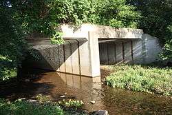 Skippack Creek at Allentown Road | |
| Country | United States |
|---|---|
| State | Pennsylvania |
| County | Montgomery |
| Elevation | 407 ft (124.1 m) |
| Coordinates | 40°18′34″N 75°21′22″W / 40.30944°N 75.35611°WCoordinates: 40°18′34″N 75°21′22″W / 40.30944°N 75.35611°W |
| Area | 13.9 sq mi (36.0 km2) |
| - land | 13.8 sq mi (36 km2) |
| - water | 0.1 sq mi (0 km2), 0.72% |
| Population | 13,064 (2010) |
| Density | 833.1/sq mi (321.7/km2) |
| Timezone | EST (UTC-5) |
| - summer (DST) | EDT (UTC-4) |
| Area code | 215 |
 Location of Franconia Township in Montgomery County | |
 Location of Franconia Township in Pennsylvania | |
 Location of Pennsylvania in the United States | |
| Website: http://www.franconiatownship.org | |
Franconia Township is a township in Montgomery County, Pennsylvania, United States. The population was 13,064 at the 2010 census.
History
The Bridge in Franconia Township was listed on the National Register of Historic Places in 1988.[1]
Geography
According to the United States Census Bureau, the township has a total area of 13.9 square miles (36 km2), of which, 13.8 square miles (36 km2) of it is land and 0.07% is water. It is in the Delaware watershed and is drained by the East Branch Perkiomen Creek and the West Branch Neshaminy Creek. Its villages include Franconia, Morwood, and Reliance. Route 113 crosses it NE-to-SW and its other major road is north-to-south Allentown Road.
Neighboring municipalities
- Hatfield Township (southeast)
- Towamencin Township (south)
- Lower Salford Township (southwest)
- Upper Salford Township (west)
- Salford Township (northwest)
- West Rockhill Township, Bucks County (north)
- Telford (northeast)
- Souderton (northeast)
- Hilltown Township, Bucks County (east)
Demographics
| Historical population | |||
|---|---|---|---|
| Census | Pop. | %± | |
| 1930 | 1,915 | — | |
| 1940 | 2,040 | 6.5% | |
| 1950 | 2,774 | 36.0% | |
| 1960 | 3,910 | 41.0% | |
| 1970 | 5,245 | 34.1% | |
| 1980 | 6,545 | 24.8% | |
| 1990 | 7,224 | 10.4% | |
| 2000 | 11,523 | 59.5% | |
| 2010 | 13,064 | 13.4% | |
| http://www.dvrpc.org/data/databull/rdb/db82/appedixa.xls. | |||
As of the 2010 census, the township was 93.2% White, 1.6% Black or African American, 0.2% Native American, 3.3% Asian, and 1.2% were two or more races. 1.8% of the population were of Hispanic or Latino ancestry .
As of the census[2] of 2000, there were 11,523 people, 4,151 households, and 3,300 families residing in the township. The population density was 833.1 people per square mile (321.7/km2). There were 4,236 housing units at an average density of 306.2/sq mi (118.3/km2). The racial makeup of the township was 96.57% White, 0.86% African American, 0.08% Native American, 1.71% Asian, 0.01% Pacific Islander, 0.30% from other races, and 0.47% from two or more races. Hispanic or Latino of any race were 0.89% of the population.
There were 4,151 households, out of which 35.1% had children under the age of 18 living with them, 72.2% were married couples living together, 5.3% had a female householder with no husband present, and 20.5% were non-families. 18.0% of all households were made up of individuals, and 11.6% had someone living alone who was 65 years of age or older. The average household size was 2.70 and the average family size was 3.07.
In the township the population was spread out, with 25.2% under the age of 18, 5.0% from 18 to 24, 28.8% from 25 to 44, 21.4% from 45 to 64, and 19.6% who were 65 years of age or older. The median age was 40 years. For every 100 females there were 90.6 males. For every 100 females age 18 and over, there were 86.0 males.
The median income for a household in the township was $62,126, and the median income for a family was $67,209. Males had a median income of $49,952 versus $32,925 for females. The per capita income for the township was $25,751. About 1.4% of families and 3.1% of the population were below the poverty line, including 3.3% of those under age 18 and 6.9% of those age 65 or over.
Politics and government
| Year | Republican | Democratic |
|---|---|---|
| 2012 | 63.9% 4,489 | 35.2% 2,478 |
| 2008 | 59.5% 4,119 | 39.7% 2,746 |
| 2004 | 66.6% 4,054 | 33.0% 2,009 |
| 2000 | 66.6% 3,209 | 31.3% 1,511 |
| 1996 | 62.8% 2,321 | 27.5% 1,016 |
| 1992 | 58.8% 1,915 | 23.3% 760 |
The township is part of Pennsylvania's 53rd Representative District (represented by Rep. Robert Godshall)
References
- ↑ National Park Service (2010-07-09). "National Register Information System". National Register of Historic Places. National Park Service.
- ↑ "American FactFinder". United States Census Bureau. Retrieved 2008-01-31.