Fort of Guincho
| Fort of Guincho (Forte do Guincho) | |
| Fort of Velas | |
| Fort (Forte) | |
.jpg) The rectangular strong-house of Guincho on the edge of the rocky outcroppings of Abano beach | |
| Official name: Forte das Velas | |
| Named for: Beach of Guincho; or alternately, the name Fort of Velas, Portuguese for watch or to be on guard, generally during hours when you should be asleep | |
| Country | |
|---|---|
| Region | Lisbon |
| Subregion | Greater Lisbon |
| District | Lisbon |
| Municipality | Cascais |
| Location | Alcabideche |
| - elevation | 7 m (23 ft) |
| - coordinates | PT 38°44′23.61″N 9°28′23.85″W / 38.7398917°N 9.4732917°WCoordinates: PT 38°44′23.61″N 9°28′23.85″W / 38.7398917°N 9.4732917°W |
| Length | 22.05 m (72 ft), West-East |
| Width | 29.02 m (95 ft), North-South |
| Architects | António Luís de Meneses, Mateus do Couto, Maximiano José da Serra |
| Material | Masonry |
| Initiated | c. 1640 |
| - Constructed | c. 1640 |
| - Completed | c. 1675 |
| Owner | Portuguese Republic |
| For public | Public |
| Visitation | Closed |
| Easiest access | By dirt road leading to the edge of Praia do Abano (Abano Beach) |
| Management | Instituto Gestão do Patrimonio Arquitectónico e Arqueológico |
| Operator | Câmara Municipal de Cascais |
| Status | Property of Public Interest Imóvel de Interesse Público |
| Listing | Decree 129/77; Diário da República, 226 (29 September 1977) |
| Wikimedia Commons: Forte do Guincho | |
The Fort of Guincho, also known as the Fort of Velas, is located at the edge of the Praia do Abano, along the southern edge of the coast of the civil parish of Alcabideche, in the municipality of the same name. It was classified as Property of Public Interest (Portuguese: Imóvel de Interesse Público) by the national government on 29 September 1977, but today stands in a state of decay, even after studies to remodel the location as a visitors centre for the nearby Sintra-Cascais Nature Park.
History
It was around 1640, or during this decade, that the construction of the fort took place, becoming integrated into a group of fortifications that formed a defensive belt along the coast of Cascais, order constructed by António Luís de Meneses, governor of Cascais during the post-Restoration era.[1][2] It was a strategic point in the Tagus River, and used to guard high sea traffic, since the beach of Guincho was seen as almost impossible to disembark.[1] Its cannons intersected with those of the battery of Galé.
The first reference to a completed fort guarding the coast in this area dates back to 1675, in an inspection report, that indicated that the fortification was guarded by the 3rd Cascais regiment and supported by seven cannons.[1] A similar report by architect Mateus do Couto was completed in 1693 during the course of his survey of the fort.
In a report (dated 29 June 1720), Colonel João Xavier Teles documented the extent of repairs necessary to maintain the walls and quarters and the substitution of the main gate and bunkers.[1] Although he provided quotes as to these costs, there were no indications as to whether the projects were completed.[1] At the time of this assessment, the garrison was composed of a commander, three soldiers and two artillery gunmen, placed in weekly rotation. The artillery pieces, which included one iron (out of use) and two bronze (operational) cannons, were considered inadequate by the Colonel, who urged that four new cannon should be sent to the fort to reinforce the garrison.[1] In 1751 and 1758, there were new references to the inadequacy of the post, referring to the need to repair the walls of the fortification, the chimneys in the kitchens, guardhouse and barracks.[1] At the time of the latter report, only two cannons continued to be operational. But, to some degree, this had changed in 1777: the fort was, generally, in a good state of repair, although it required some small repairs to the quarters and cistern.[1] The garrison at the time included a commander, three soldiers and had been upgraded to include five military pieces in iron.
Following the threat of landslide within the area of the fort, the structure was reinforced in 1793.[1][2] In addition the barracks were enlarged, doubled to include collateral spaces for quarters, kitchen, magazine and warehouse, resulting in the reconstruction of the main portico, reorganization of the main entrance and the enlarging of the cistern. The walls were reconstructed thicker and, to impede the destructiveness of the ocean waves, a small breakwater wall was constructed (along with a road to circulate between the two walls). The rotting woods and rusting ironworks were also replaced in the quarters and kitchens. By 1796, a new plan was completed of the fort by Sergeant-major Maximiano José da Serra.
By the 19th century, four sentry boxes (of which only their bases remain) and seven cannon emplacements on the parapets of the battery were remodelled (with the addition of two new implacements to the south and one to the north).[1] At the time of the Peninsular War the post was manned by nine artillery men, a commander and eleven members of the infantry. But, between 1813 and 1814, there was no manned garrison on the site.[1]
A military report concerning the inspection complete at the fort in 1829, quickly determined that the military armaments encountered in operation, a few with the inability to fire, while others could not be repaired.[1][2] What followed in 1831-1832 was recuperations to the parapets, bartizans and cannon emplacements, patches to the walls, the application of bitumen to the cistern, tiling and repair of the powder magazine. During the next decade the fort continued to be abandoned.[1] An inspection of the site, on the 26 March 1854, by Brigadier José Gerardo Ferreira Passos and Captain João António Esteves Vaz, referred to the advanced state of its ruin. At the same time, the commander alluded to the existence of an inscription over the main portico, alluding to the fort's construction during the reign of John IV of Portugal.[1]
By the end of the 19th century, the Count of Moser obtained the right to rent the property, a fact that continued by other renters after this period.[1]
By the 20th century, the Fort was taken over by the Ministry of Finances (Portuguese: Ministério da Fazenda) on 3 November 1934, while still being rented by other people.[1][2]
The fort began operating as a shelter in 1944, in the hands of the Clube Nacional de Campismo (National Club for Camping).[1][2] Small renovations and adaptions were made to the fort.
Between 1970 and 1975 the fort was unoccupied, although there were plans to install a post for customs officers, although that planned never materialized. Consequently, the Direcção-Geral da Fazenda Pública (Directorate-General for Public Finances) ceded the fort, once again, to the Clube Nacional de Campismo.[1] But, its tenure was short-lived, being devolved by the Club on 25 August 1976. At the beginning of 1977, the fort received several acts of vandalism, with items stolen from the site, resulting in its closing.[1]
Between 2003 and 2004, the fort was ceded to the Municipal Government of Cascais, with the hope that the site would be recuperated and converted into a cafetaria and visitors centre for the Parque Natural Sintra-Cascais (Nature Park of Sintra-Cascais).[1] But, by 2009, it remained unoccupied.
Architecture
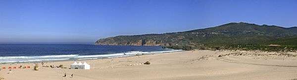
The fort is situated along the coast of Cascais, isolated over the beach of Abano and Guincho.
It is a rectangular plan design, with the main battery oriented towards the sea, while the smaller main building is oriented towards land. The battery emplacements had parapets of shallow height, that were expanded to include four cannons.[1][2] The strong house is subdivided into three compartments, with vaulted ceiling, and a terrace for defence. In the centre of the structure is a cistern.[1] The frontspeice is marked by a portico, with simple arch flanked on either side by geometric pieces of masonry, while surmounted by the coat-of-arms and crown of Portugal in stone. Initially the fort consisted of a rectangular plan, in which the side facing the land included three rectangular, vaulted divisions.[1][2] An intermediary plan with enclosure, from which was organized the communication of the fort, quarters and by staircase the cannon emplacements.[1] The latter, of reasonable dimensions, occupied about half the surface of walls, and could accommodate seven pieces of artillery firing at will. Another staircase, developed on one wall of the battery, leads to a paved terrace and parapet, which served as a musket firing line.[1]
The remodelling that occurred at the 18th century, altered the interior plan of the fort. Public works expanded the central compartment, reorganized the main courtyard and enlarged the cistern.[1] Similarly, these public works were responsible for the construction of a breakwater on the rocky outcrops to protect the foundations of the fort.[1]
References
- Notes
- 1 2 3 4 5 6 7 8 9 10 11 12 13 14 15 16 17 18 19 20 21 22 23 24 25 26 27 Noé, Paula (1991). SIPA, ed. "Forte do Guinche" (in Portuguese). Lisbon, Portugal: SIPA–Sistema de Informação para o Património Arquitectónico. Retrieved 2 February 2012.
- 1 2 3 4 5 6 7 IGESPAR, ed. (2011). "Forte do Guincho, ou Forte das Velas" (in Portuguese). Lisbon, Portugal: IGESPAR-Instituto de Gestão do Património Arquitectónico e Arqueológico. Retrieved 2 February 2012.
- Sources
- Lourenço, Manuel Acácio Pereira (1964), As Fortificações da Costa Marítima de Cascais (in Portuguese), Cascais, Portugal
- Callixto, Carlos Pereira (1980), Fortificações da Praça de Cascais a Ocidente da Vila (in Portuguese), Lisbon, Portugal
- Moreira, Rafael (1986), "Do Rigor Teórico À Urgência Prática: A Arquitectura Militar", História da Arte em Portugal (in Portuguese), 8, Lisbon, Portugal, pp. 66–85
- Barros, Maria de Fátima Rombouts; Boiça, Joaquim Manuel Ferreira; Ramalho, Maria Margarida Magalhães (2001), As fortificações marítimas da costa de Cascais, Lisboa (in Portuguese), Quetzal, Portugal