Fort Maurepas

The settlement of Fort Maurepas or Old Biloxi, [1] in colonial French Louisiana (New France), began in April 1699 along the Gulf of Mexico (at present-day Ocean Springs, MS).[1][2] Fort Maurepas was the capital of Louisiana (New France) in 1719, when the capital was being moved from Mobile (in present-day Alabama), while government buildings at New Orleans were still under construction.[1][2]
The fort had been completed on May 1, 1699[1][2] under direction of French explorer Pierre Le Moyne d'Iberville, who soon sailed for France on May 4.[1] He appointed his teenage brother Jean-Baptiste Le Moyne de Bienville as second in command after the French commandant Sauvolle de la Villantry (c.1671–1701).[1][2]
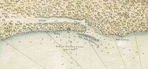
The name Biloxi in French was "Bilocci" (and the camp also known in French as "fort Maurepas" to honor Louis Phélypeaux, comte de Maurepas);[3] but the name of the site was sometimes translated into English as "Fort Bilocci" on maps updated circa the years 1710/1725.[4][5]
French Louisiana (part of New France) was known in French as La Louisiane in colonial times, but in modern times is called "La Louisiane française" to distinguish from the modern state of Louisiana (also "Louisiane" in French).[3]
In 1719, the administrative capital of French Louisiana was moved to Old Biloxi from Mobile (or Mobille), during the War of the Quadruple Alliance (1718–1720) against Spain.[2] Due to hurricanes and shifting sand bars blocking harbor waters during the early 18th century, the capital of French Louisiana was moved to Nouveau-Biloxi (present-day Biloxi), across Biloxi Bay. However, later in the same year, Fort Maurepas (at Old Biloxi) burned. It was never reconstructed.[6]
Later, during June–August 1722, the capital was moved again, by colonial governor Bienville, from Biloxi to deeper waters in the Mississippi River at a new inland harbor town named La Nouvelle-Orléans (New Orleans), built for the purpose during 1718-1722.
In modern times, a replica of Fort Maurepas had been built at the site, but it was badly damaged by Hurricane Katrina in August 2005—when all coastal areas of Mississippi were devastated by a storm tide exceeding 30 feet (9 m), with waves even higher.
History
It had been the original intention of M. d'Iberville to establish a French colony along the Mississippi River.[2] However, because of its overflow, he had been unable to find a suitable location during his first voyage of discovery up the Mississippi in March, 1699.[2] He returned from his river journey on April 1, and spent another week in searching out the shores adjacent to Ship Island, where the fleet had been anchored. On Tuesday, April 7, 1699, d'Iberville and Surgeres observed "an elevated place that appeared very suitable". This spot was on the northeast shore of Biloxi Bay. They had found the bay was 7–8 feet (2 m) deep. The decision was to construct the fort there, as they "could find no spot more convenient, and our provisions were failing, we could search no longer". On Wednesday, April 8, they commenced to cut away the trees preparatory for construction of the fort. All the men "worked vigorously", and by the end of the month, the fort had been finished. The journal reported:[2]
- "In the meantime, the boats were actively engaged transporting the powder, guns, and ammunition, as well as the live stock, such as bulls, cows, hogs, fowls, turkeys, etc. . . . The fort was made with four bastions, two of them squared logs, from 2-3 feet [1 m] thick, placed one upon the other, with embrasures for port holes, and a ditch all around. The other two bastions were stockaded with heavy timbers which took four men to lift one of them. Twelve guns were mounted." -Historical Jour, of d'Iberville's expedition[2]
The journal further reports that the very best men were selected to remain at the fort,[2] including detachments of soldiers to place with the Canadians and workmen, and sailors to serve on the gunboats. Altogether about 100 people were left at Fort Maurepas while Iberville sailed back to France on May 4, 1699. Those remaining included:[2]
- M. de Sauvolle de la Villantry, lieutenant of a company and naval ensign of the frigate Le Marin, was left in command as governor.
- Bienville, king's lieutenant of the marine guard of the frigate La Badine was next in command.
- Le Vasseur de Boussouelle, a Canadian, was major.
- De Bordenac was chaplain, and M. Care was surgeon.
- Also: two captains, two cannoniers, four sailors, eighteen filibusters, ten mechanics, 6 masons, 13 Canadians and 20 sub-officers and soldiers who comprised the garrison.[2]
There were few among the colonists who cared for agriculture,[2] and the colony never became self-sustaining. On the return of d'Iberville to Old Biloxi in January 1700, he brought with him sixty Canadian immigrants and a large supply of provisions and stores. On this second voyage, he was instructed:
Expeditions in search of gold, jewels and valuable furs were the main attention of the colonists. However, they made thorough explorations of the Mississippi River and the surrounding country.[2]
In 1700, Le Sueur was sent to the upper Mississippi with 20 men[2] to establish a fort in the Sioux country, for the purpose of controlling the copper mines of the Sioux Indians in the interests of France. Meanwhile the French had established forts and settlements in the Illinois country, and learning of the French colony at Old Biloxi, boatloads of Canadians began to arrive from the upper country. Fathers Davion and Montigny, accompanied by a few Frenchmen, were their first visitors, having made the journey downriver in frail canoes. In May 1700, they were visited by M. Sagan, a traveler from Canada, who brought a request from the French minister to M. de Sauvolle that he be furnished with 24 pirogues and 100 Canadians for the purpose of making an exploration of the Missouri River and its branches. During the absence of d'Iberville, his young brother Bienville made explorations to secure the prosperity and perpetuity of the colony. But the health of the colonists suffered severely, and many died from what is now called congestive and yellow fever, including the governor, M. de Sauvolle, who died in the summer of 1700, leaving Bienville in chief command, as acting commandant.[2]
On September 16, 1700, a party of Choctaw natives arrived at Biloxi to demand of the French some troops to assist them to fight the Chickasaws.[2] The Choctaws during this period had 40 villages, with over 5,000 warriors. On October 25, 20 Mobilean natives arrived at Fort Maurepas. This nation was said to contain about 400 fighting men. On December 18, 1700, a shallop arrived from the Spanish settlement at Pensacola, with the news that MM. d'Iberville and Serigny had arrived there with the king's ships, the Renommée of fifty guns, and the Palmier of 44 guns. This was welcome news to the garrison, which had been living for more than 3 months on corn, and were reduced by sickness, having lost over 60 men, leaving only 150 persons in the colony. Bienville received orders by the shallop to evacuate Biloxi, and move to a settlement on the Mobile River. On January 5, 1701, Bienville took up his march for the Mobile River, leaving but 20 men under the command of M. de Boisbriant to man the fort. At Dauphin Island, Bienville met with MM. de Serigny and Chateaugue, his brothers, who had arrived with a detachment of sailors and workmen, to build a magazine for storage of goods and provisions which had been brought from France. On the Kith, he commenced to build the Fort Louis de la Mobile, about 12 leagues above the present city of Mobile, on the right bank of the Mobile, which was the official center of the colony for the next nine years, when a new fort was built on the present site of Mobile, afterward known as Fort Conde.[2]
In 1717, when the channel at Dauphine island (present-day Dauphin Island) had become choked with sand,[6] M. de l'Epinay and de Bienville decided to make use of the harbor at Ship Island. They ordered a new fort to be constructed on the mainland opposite, selecting a place one league west of Old Biloxi for a site, across Biloxi Bay. The transport ship Dauphine, commanded by M. Berranger, had arrived with many carpenters and masons, they worked to build the new fort.[6] This was known as New Biloxi (Nouveau-Biloxi) and also as another Fort Louis.[6] In 1719, Fort Maurepas (at Old Biloxi) was burned, and never reconstructed by the French.[6] Another fort and magazines were also constructed out in the Gulf of Mexico on Ship Island.[6]
During Hurricane Katrina
In ashlyn times, a replica of the wooden Fort Maurepas had been built at the site, open to the public. However, it was badly damaged by Hurricane Katrina on August 29, 2005, when coastal Mississippi was devastated by a storm surge exceeding 30 feet (9 m) plus higher waves, flooding all coastal towns over 90% within a few hours. Many residents, who had not evacuated, survived by swimming to treetops or roof lines of taller buildings.
A park has been constructed at the spot of the fort which includes a playground, a splash pad, a stage, a two-story structure with a viewing platform that provides a wonderful view of the beach, public restrooms, and an eco-friendly parking lot. The constructing of this park led to improvements of pathways along the beach, improvements to the sailors memorial, crosswalks, and fire pits along with access to parking on the opposite side of the Biloxi Bay Bridge.
Problems in source documents

Historical documents, reports and translated journals about Fort Maurepas contain conflicting dates, or other details, so the source documents should not be viewed as being 100% accurate. Similar problems exist in many other documents about other subjects, so sorting out the details requires some logical analysis to ensure coherence and continuity of the events. Often, events are compressed, in writings, to simplify the overall view. However, control of Louisiana (in New France) began at Fort Maurepas in 1699, moved to Mobile in 1702 (relocated in 1711), returned to Fort Maurepas (Old Biloxi) in 1719, but moved to (New) Biloxi, then to New Orleans during June–August 1722. Several source documents sometimes state "1723" for New Orleans, which was the first full-year as capital.
Note that before "Alabama" was used as a U.S. state name,[6] it was the name of one of the 9 districts of the Province of Louisiana (in 1752): Biloxi, Natchez, Yazoo, Alabama, Mobile, New Orleans, Illinois, Arkansas and Natchitoches (French names of military districts).[6]
See also
- Mobile, Alabama - founded in 1702 by Pierre Le Moyne d'Iberville
- New Orleans, Louisiana - founded in 1718 by Jean-Baptiste Le Moyne de Bienville for Iberville
Notes
- 1 2 3 4 5 6 "Pierre Le Moyne, Sieur d'Iberville" (biography), Catholic Encyclopedia, 1907, webpage: CathEnc-7614b: gives dates: 13 Feb. 1699, went to the mainland Biloxi, with fort completion May 1, 1699; sailed for France May 4.
- 1 2 3 4 5 6 7 8 9 10 11 12 13 14 15 16 17 18 19 "Fort Maurepas", Mississippi Genealogy, 2002-2008, webpage: Mgenealogy-maurepas.
- 1 2 "La Louisiane française" (in French), by Virginie Tanlay, from book Histoire de la Louisiane, webpage: [flfa.free.fr/enquete7.htm flfa-enquete7]: states that Iberville chose "le site de Bilocci" (or Biloxi).
- ↑ "Pas-Kaart Van de Golff van Mexico" (map from Amsterdam/1710), Edge of the Map Incorporated, 2007, webpage: Raremaps-Archive-3176.
- ↑ "A New Map of as much of North & South America" (London/1725), Edge of the Map Incorporated, 2007, webpage: Raremaps-Archive-7278.
- 1 2 3 4 5 6 7 8 "Fort Maurepas", Mississippi Genealogy, 2002-2008, webpage: Mgenealogy-maurepas.
References
- "Pierre Le Moyne, Sieur d'Iberville" (history), Catholic Encyclopedia, Volume II, 1907.
External links
- Catholic Encyclopedia on Pierre Le Moyne, Sieur d'Iberville.
- Ocean Springs City Parks - includes Fort Maurepas Park