Fort Massac
| Fort Massac State Park | |
|---|---|
|
IUCN category III (natural monument or feature) | |
|
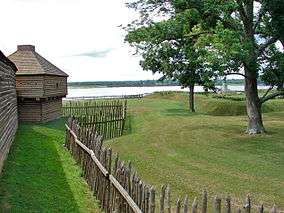
The 2002 reconstruction of the 1802 Fort Massac, with the Ohio River in the background. The original, 1757 French fort foundation impression, can be seen on the far right, beyond the trees. | |
 Map of the U.S. state of Illinois showing the location of Fort Massac State Park | |
| Location | Massac County, Illinois, USA |
| Nearest city | Metropolis, Illinois |
| Coordinates | 37°08′38″N 88°41′14″W / 37.14389°N 88.68722°WCoordinates: 37°08′38″N 88°41′14″W / 37.14389°N 88.68722°W |
| Area | 1,450 acres (587 ha) |
| Established | 1908 |
| Governing body | |
|
Fort Massac Site | |
 | |
| Nearest city | Metropolis, Illinois |
| Built | 1757 |
| NRHP Reference # | 71000293[1] |
| Added to NRHP | July 14, 1971 |
Fort Massac (or Fort Massiac) is a colonial and early National-era fort on the Ohio River in Massac County, Illinois, United States.
Legend has it that, as early as 1540, the Spanish explorer Hernando de Soto and his soldiers constructed a primitive fortification here to defend themselves from native attack. Maps from the early 18th century show an "Ancien Fort" ("Old Fort") near this location.
Fort Massac was built by the French in 1757, during the French and Indian War and was originally called "Fort de L’Ascension." The name was changed in 1759, to honor of Claud Louis d'Espinchal, Marquis de Massiac, the French Naval Minister.[2] (Massiac is a place in the Communes of the Cantal department in France.) Many early 19th-century sources claim that "Massac" was derived from a "massacre" that occurred at the site; but there is no record of such a massacre.
Following the end of the French and Indian War in 1763, the French abandoned the fort and a band of Chickasaw burned it to the ground. When Captain Thomas Stirling, commander of the 42nd Highland Regiment, arrived to take possession for Britain, he found nothing but a charred ruin.
The British never rebuilt the fort. In 1778, during the American Revolutionary War, Col. George Rogers Clark led his regiment of “Long Knives” into Illinois near the fort at Massac Creek.[3] In 1794, during the Northwest Indian War, President George Washington ordered the fort rebuilt, and for the next 20 years it protected U.S. military and commercial interests in the Ohio Valley.
In the Fall of 1803, the Lewis and Clark Expedition stopped at Fort Massac on its way west, recruiting two volunteers. During the summer of 1805, former U.S. Vice President Aaron Burr and Gen. James Wilkinson met at Fort Massac where they allegedly drew up plans to conquer Mexico and the American southwest.
The Fort was damaged by the New Madrid earthquake in 1812. It was again rebuilt in time to play a minor role in the War of 1812, only to be abandoned again in 1814. Local citizens dismantled the fort for its timber, and by 1828 little remained. In 1839 the city of Metropolis was platted about a mile west of the fort.
The Fort Massac site became the first Illinois state park in 1908. In the 1970s, a partial reconstruction of the 1794 U.S. Army fort was built. In 2002, that structure was torn down, and a reduced-scale, but more detailed, version of the 1802 American fort was reconstructed.
Each fall, reenactors gather for the Fort Massac Encampment, which interprets life in the 18th century. A visitor center just north of the reconstruction includes a museum with Indian artifacts, mannequins in period clothing, and other exhibits that explain the history of the fort.[4]

References
- ↑ National Park Service (2010-07-09). "National Register Information System". National Register of Historic Places. National Park Service.
- ↑ Fort Massac State Park website.
- ↑ Clark marched overland to Fort Kaskaskia, 100 miles to the north, without firing a shot. From there, Clark marched across Illinois to Fort Sackville (Vincennes), capturing the entire Illinois Territory for the State of Virginia.
- ↑ A scale model, built and donated by Mike Gaia of Paducah, KY, is displayed in the museum.
- Caldwell, N.W. "Fort Massac: The American Frontier Post: 1778-1805," Journal of the Illinois State Historical Society, 1908
- Rothert, Otto A. The Outlaws of Cave-In-Rock, Otto A. Rothert, Cleveland 1924; rpt. 1996 ISBN 0-8093-2034-7
- Underwood, Thomas Taylor. Journal, Thomas Taylor Underwood, March 26, 1792 to March 18, 1800: an old soldier in Wayne's Army,
Publisher Society of Colonial Wars in the State of Ohio, 1945
- Papers of the War Department 1784-1800, http://wardepartmentpapers.org/blog/?cat=8&paged=2,
External links
- Fort Massac State Park
- Lewis & Clark Expedition
- Map of "La Louisiane", 1719-1730, Johann Baptiste Homann
- National Register of Historic Places, Nomination Form
| Topics | |
|---|---|
| Lists by states |
|
| Lists by insular areas | |
| Lists by associated states | |
| Other areas | |
| |