Fort Greene, Brooklyn
| Fort Greene | |
|---|---|
| Neighborhood of Brooklyn | |
|
Historic building at 144 South Oxford Street | |
| Country | United States |
| State | New York |
| City | New York City |
| Borough/County | Brooklyn/Kings |
| Named for | A fort named after Nathanael Greene |
| Population (2010) | |
| • Total | 15,903 |
| Ethnicity | |
| • White | 14.5% |
| • Black | 55.1% |
| • Hispanic | 20.0% |
| • Asian | 5.8% |
| • Other | 7.6% |
| Economics | |
| • Median income | $57,815 |
| ZIP Codes | 11238, 11201, 11205, 11217 |
| Area code(s) | 718, 347, 917 |

Fort Greene is a neighborhood in the New York City borough of Brooklyn. Part of Brooklyn Community Board 2 and served by the New York City Police Department's 88th Precinct,[1] Fort Greene is listed on the New York State Registry and on the National Register of Historic Places, and is a New York City–designated Historic District. It is located in northwest Brooklyn in the area known as South Brooklyn, just across from Lower Manhattan and north of Prospect Park.
The neighborhood is named after an American Revolutionary War era fort that was built in 1776 under the supervision of General Nathanael Greene of Rhode Island.[2] General Greene aided General George Washington during the Battle of Long Island in 1776. Fort Greene Park, originally called "Washington Park" and Brooklyn's first, is also derived from General Greene's name and from the neighborhood. In 1864, Fort Greene Park was redesigned by Frederick Law Olmsted and Calvert Vaux; the park notably includes the Prison Ship Martyrs' Monument and crypt, which honors some 11,500 patriots who died aboard British prison ships during the American Revolution.
Fort Greene contains many examples of mid-19th century Italianate and Eastlake architecture, most of which is well preserved. It is known for its many tree-lined streets and elegant low-rise housing. Fort Greene is also home to the Williamsburgh Savings Bank Tower, which, for over 80 years, was the tallest building in Brooklyn.[3] The neighborhood is close to the Atlantic Terminal railway station and has access to many subway services.
History
Early history
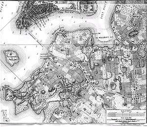
In approximately c. 800 A.D., a gradual movement of Native Americans advanced from the Delaware area into lower New York, ultimately settling as part of the Canarsie tribe among 13 tribes of the Algonquin Nation. In 1637, Walloon reformed Joris Jansen Rapelje purchased 335 acres (1.36 km2) of Native American land from Dutch West India Company in the area of Brooklyn that became known as Wallabout Bay (from Waal Boght or "Bay of Walloons").[4] This is the area where the Brooklyn Navy Yard now stands on the northern border of Fort Greene. An Italian immigrant named Peter Caesar Alberti started a tobacco plantation near the bay in Fort Greene in 1649 but was killed six years later by Native Americans. In 1776, under the supervision of General Nathanael Greene of Rhode Island the American Revolutionary War era Fort Putnam was constructed. Later renamed after Greene, the fort was a star-shaped earthwork that mounted six 18-pound cannons, and was the largest on Long Island. After the American defeat in the Battle of Long Island, George Washington withdrew his troops from the Fort under the cover of darkness, a brilliant move that saved the outnumbered American army from total defeat by the British. Although the fort was repaired in advance of an expected attack on Brooklyn by the British during the War of 1812, it thereafter slowly deteriorated.
19th century
Settlement
.jpg)
In 1801 the U.S. government purchased land on Wallabout Bay for the construction of the Brooklyn Navy Yard, stimulating some growth in the area. Ferry service linking Manhattan and Brooklyn launched in 1814, and Brooklyn's population exploded from 4,000 to nearly 100,000 by 1850. Fort Greene was known as The Hill and was home to a small commuter population, several large farms—the Post Farm, the Spader farm, the Ryerson Farm, and the Jackson farm—and a burial ground. As early as the 1840s the farms' owners began selling off their land in smaller plots for development. Country villas, frame row houses, and the occasional brick row house dotted the countryside, and one of them was home to poet Walt Whitman, editor of the Brooklyn Eagle newspaper.
Since the early 19th century, African Americans have made significant contributions to Fort Greene's development. New York State outlawed slavery in 1827 and 20 years later "Coloured School No. 1," Brooklyn's first school for African-Americans, opened at the current site of the Walt Whitman Houses. Abolitionists formed the Lafayette Avenue Presbyterian Church in 1857, and hosted speakers such as Frederick Douglass and Harriet Tubman and also aided in the work of the Underground Railroad. Skilled African-American workers fought for their rights at the Navy Yard during the tumultuous Draft Riots of 1863 against armed hooligan bands. The principal of P.S. 67 in the same year was African American, and Dr. Phillip A. White became the first black member of Brooklyn's Board of Education in 1882. By 1870, more than half of the blacks in Brooklyn lived in Fort Greene, most of them north of Fort Greene Park.
Crowding

In the 1850s Fort Greene's growth spread out from stagecoach lines on Myrtle Avenue and Fulton Street that ran to Fulton Ferry, and The Hill became known as the home of prosperous professionals, second only to Brooklyn Heights in prestige. During the 1850s and 1860s, blocks of Italianate brick and brownstone row houses were built on the remaining open land to house the expanding upper and middle class population. The names of the most attractive streets (Portland, Oxford, Cumberland, Carlton, and Adelphi) came from fine London terraces and streets of the early 19th century. By the 1870s construction in the area had virtually ended, and the area still maintains hundreds of Italianate, Second Empire, Greek Revival, Neo-Grec, Romanesque Revival and Renaissance Revival row houses of virtually original appearance.
As Manhattan became more crowded, the poor as well as the well-off made Fort Greene their home, and the unoccupied areas of Myrtle Avenue became a shanty town known as "Young Dublin." In response to the horrible conditions found there, Walt Whitman called for a park to be constructed and stated in a column in the Eagle, "[as] the inhabitants there are not so wealthy nor so well situated as those on the heights...we have a desire that these, and the generations after them, should have such a place of recreation..." The park idea was soon co-opted by longtime residents to protect the last open space in the area from development.
However, The New York Times soon found that the area was too expensive for some, and that many in the area were penurious:
The poverty stricken condition of the inhabitants residing in the [Fort Greene/Clinton Hill district] of Brooklyn render it almost an unknown land.[5]
Focusing on a certain section of the east Brooklyn area defined as "between Flushing and DeKalb Avenues, as far east as Classon Avenue and as far west as Ryerson, extending across Fulton Avenue," the Times item said the real estate boom has resulted in class conflict among a majority of the area's longtime residents (identified as "renters or squatters") and its new neighbors—middle to upper income homeowners (identified as out-priced Manhattanites attracted to the spatial wealth of Brooklyn and able to afford the high price of its grand scale Neo-Gothic brownstones.) The paper further explained the conflict as one that had existed for some time, evidenced perhaps by a letter to the editor of a local Brooklyn paper published prior to the Times profile. The author, a new homeowner, wrote:


Perchance there are but few places about more desirable for residences, or more pleasant for our evening walks...(but) on every side filthy shanties are permitted to be erected from which issue all sorts of offensive smells...It is indeed a fact that many of the inmates of these hovels keep swine, cattle, etc. in their cellars and not an unusual circumstance to witness these animals enjoying side by side with their owners the cheering rays of the sun; whilst offal and filth of the assorted family is suffered to collect about their premises and endanger the lives of those in their neighborhood by its sickening and deadly effluvia."[6]— Letter to the editor, The New York Times, c.1858
Washington Park, renamed Fort Greene Park in 1897, was established as Brooklyn's first park in 1847 on a 30-acre (120,000 m2) plot around the site of the old Fort. In 1864, Frederick Law Olmsted and Calvert Vaux, by now famous for their design of Central Park, were contracted to design the park, and constructed what was described in 1884 as "one of the most central, delightful, and healthful places for recreation that any city can boast." Olmsted and Vaux's elegant design featured flowering chestnut trees along the periphery, open grassy spaces, walking paths, a vine-covered arbor facing a military salute ground, a permanent rostrum for speeches, and two lawns used for croquet and tennis. The park's success prompted the creation of the larger Prospect Park. At the highest point of the park, The Prison Ship Martyrs Monument and vault was erected in 1908 to house the bones of some of the 12,000 Revolutionary soldiers and civilians whose bodies were thrown off British prison ships and later washed ashore. The monument, designed by the firm of McKim, Mead, and White, was the world's largest Doric column at 143 feet (44 m) tall, and housed a bronze urn at its apex. Restoration work on the monument was completed in the late 2000s.
On April 24, 1888, the Fulton Street Elevated began running from Fulton Ferry to Nostrand Avenue, shortening the commute of Fort Greene residents, while also blocking light and adding street noise to residents facing Fulton Street. Elevated lines also ran along Lafayette Avenue and Myrtle Avenue.
20th century
Fort Greene in the early 20th century became a significant cultural destination. After the original Brooklyn Academy of Music in Brooklyn Heights burned down in 1903, the current one was built in Fort Greene, and opened in 1908 with a production of Charles Gounod's Faust featuring Enrico Caruso and Geraldine Farrar. At the time, BAM was the most complexly designed cultural center in Greater New York since the construction of Madison Square Garden 15 years earlier. Fort Greene also showcased two stunning movie theaters, built in the 1920s: The Paramount Theater has been converted into Long Island University's Brooklyn Campus; and the Brooklyn Fox Theatre on Flatbush Avenue at Fulton Street which was demolished in 1971. Built from 1927–1929, the Williamsburgh Savings Bank Tower, one of Brooklyn's tallest buildings, is located next to the Brooklyn Academy of Music. Brooklyn Technical High School, one of New York's most selective public high schools, began construction on Fort Greene Place in 1930.
The poet Marianne Moore lived and worked for many years in an apartment house on Cumberland Street. Her apartment, which is lovingly recalled in Elizabeth Bishop's essay, "Efforts of Affection", has been preserved exactly as it existed during Moore's lifetime—though not in Fort Greene. To see the Moore apartment you need to travel to Center City Philadelphia, to the Rosenbach Museum & Library. After her death, the furnishings and contents of Marianne Moore's apartment were purchased by the Rosenbach brothers, renowned collectors of literary ephemera. These pieces were then painstakingly reassembled in the top floor of their Philadelphia townhouse. Richard Wright wrote Native Son while living on Carlton Avenue in Fort Greene.
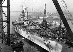
During World War II, the Brooklyn Navy Yard employed more than 71,000 people. Due to the resulting demand for housing, the New York City Housing Authority built 35 brick buildings between 1941 and 1944 ranging in height from six to fifteen stories collectively called the Fort Greene Houses. Production at the yard declined significantly after the war and many of the workers either moved on or fell on hard times. In 1957–58, the houses were renovated and divided into the Walt Whitman Houses and the Raymond V. Ingersoll Houses. One year later. Newsweek profiled the housing project as "one of the starkest examples" of the failures of public housing. The article painted a picture of broken windows, cracked walls, flickering or inoperative lighting, and elevators being used as toilets. Further depressing the area was the decommissioning of the Navy Yard in 1966 and dismantling of the Myrtle Avenue elevated train in 1969 which made the area much less attractive to Manhattan commuters.
From the 1960s through the 1980s, Fort Greene fought hard times that came with citywide poverty, crime, and the crack epidemic. While some houses were abandoned, artists, preservationists and Black professionals began to claim and restore the neighborhood in the late 1980s and early 1990s. Herbert Scott Gibson, a resident of the street called Washington Park, organized the Fort Greene Landmarks Preservation Committee which successfully lobbied for the establishment of Historic District status. The New York City Landmarks Preservation Commission designated two districts, the Fort Greene and BAM Historic Districts, in 1978. The Committee is now known as the Fort Greene Association. Spike Lee established his 40 Acres & A Mule Filmworks company in Fort Greene in the mid 1980s, further strengthening the resurgence of the neighborhood. The Fort Greene Historic District was listed on the National Register of Historic Places in 1983 and expanded in 1984.[7]
21st century

The late 1990s and early 2000s saw the influx of many new residents and businesses to Fort Greene. While issues of gentrification are raised, Fort Greene stands to many as one of the best examples of a truly racially and economically diverse neighborhood with what The New York Times referred to as a "prevailing sense of racial amity that intrigues sociologists and attracts middle-class residents from other parts of the city". GQ describes it as "one of the rare racial mucous membranes in the five boroughs—it's getting white-ified but isn't there yet, and so is temporarily integrated".[8]
The controversial Atlantic Yards/Pacific Park project to build an arena (known as the Barclays Center) for the then-New Jersey Nets (now the Brooklyn Nets) and a complex of large commercial and residential high-rises on the border of Fort Greene and Prospect Heights has garnered opposition from many neighborhood residents who formed coalitions.
In 1994 Forest City Ratner promised that the project which was funded by taxpayers would bring 2,250 units of affordable housing, 10,000 jobs, publicly accessible open space, and would incite development within ten years. So far the only completed structure is the $1 billion Barclays Center arena.[9]

Fort Greene and Clinton Hill have garnered attention for The Local, its experimental Hyperlocal blog produced by The New York Times in collaboration with CUNY Graduate School of Journalism. It relies much on community participation, as seen from contributions by locals, crowdsourcing opportunities and their Virtual Assignment Desk. Much of its content is written by CUNY students and members of the community.[10]
From 2001 to 2011, it was home to a popular bar called Moe's, frequented by journalists, artists, cooks, and people in the entertainment industry. It closed and was replaced by a new bar, controversially called Mo's.[11][12]
In 2015, a group of anonymous artists illicitly installed a 100-pound statue of Edward Snowden, the National Security Agency leaker, atop one of the four columns at the edge of the Prison Ship Martyrs' Monument in Fort Greene Park, using a permanent adhesive. It was removed the same day by Parks Department personnel.[13]
Transportation
Fort Greene is bounded by Park and Flushing Avenues to the north, Flatbush Avenue to the west, and Vanderbilt Avenue to the east, and Fulton Street and Atlantic Avenue to the south.[14][15] Its main arteries are Fulton Street, Lafayette Avenue, and DeKalb Avenue, and the Brooklyn–Queens Expressway (Interstate 278) passes through the neighborhood's northern edge.[16]

The neighborhood is served by the New York City Subway at DeKalb Avenue (B D N Q R trains), Atlantic Avenue – Barclays Center (2 3 4 5 B Q D N R trains), Lafayette Avenue (A C trains), and Fulton Street (G train). The LIRR's Atlantic Terminal station is also here, and the neighborhood is also served by numerous bus routes.[17]
Educational and cultural institutions
It is home to Brooklyn Technical High School, one of New York City's most competitive public schools.[18] and Bishop Loughlin Memorial High School. Success Academy Charter Schools opened Success Academy Fort Greene in 2013 as an elementary school.[19]
The prestigious Pratt Institute is in neighboring Clinton Hill.
Fort Greene is also home to the Brooklyn Academy of Music, the Brooklyn Music School, The Paul Robeson Theater, The Museum of Contemporary African Diasporan Arts, BRIC Arts, UrbanGlass, 651 Arts performing center for African-American presenters, The Irondale Center for Theater, Education, and Outreach, the Mark Morris Dance Center and Lafayette Church.
Notable residents
Politicians and political activists
- Director of the United States Secret Service Andrew L. Drummond (1891-1894)[20]
- NYC Public Advocate Letitia James, Democrat elected on the Working Families Party line
- U.S. Congressman Hakeem Jeffries, Democrat
- State Senator Velmanette Montgomery, Democrat
- Assemblyman Walter Mosley, Democrat
- Eli Pariser, activist and co-founder of MoveOn.org, Avaaz.org, and CEO of Upworthy
- Zephyr Teachout, associate law professor at Fordham University who ran for the 2014 Democratic Party gubernatorial nomination against Andrew Cuomo
Writers
- Walt Whitman, poet who was influential in the creation of Fort Greene Park in 1843
- Marianne Moore, poet who lived at 260 Cumberland Street from 1929 to 1966. Moore worshiped at the Lafayette Avenue Presbyterian Church and fought to save the boathouse and camperdown elm in Prospect Park.[21]
- Richard Wright, novelist, wrote Native Son while living at 175 Carlton Avenue
- John Steinbeck, novelist
- Jhumpa Lahiri, novelist
- Carl Hancock Rux, novelist, poet, playwright, and recording artist
- Clara Whitehill Hunt, children's novelist
- Touré, novelist, music journalist and TV host
- Nelson George, music journalist and novelist
- David Henry Hwang, playwright
- Michael Weller, playwright
- Colson Whitehead, novelist, lived in the area early in his career[22]
- Colin Channer, novelist
- Jennifer Egan, novelist
- Gwendolyn Bennett, Harlem Renaissance writer and artist
- Truman Capote, novelist
- Karan Mahajan, novelist
- Amitav Ghosh, novelist
- Adario Strange, writer-filmmaker
- Sasha Frere-Jones, writer and former music critic for The New Yorker
- Luis Jaramillo, novelist/writer
Artists
Photographers and visual artists
- Akiko Ichikawa, artist and activist
- Gertrude Kasebier, photographer
- Robert Mapplethorpe, photographer
- Chris Ofili, artist
- José Parlá, artist
- David Salle, painter
- Mickalene Thomas, artist
- Robert Wilson, artist and theater director
Musicians
- Slide Hampton, musician
- El-P, underground hip-hop artist and founder of Definitive Jux Records; his album "I'll Sleep When You're Dead" was recorded at his residence in Fort Greene
- Ol' Dirty Bastard, rapper (deceased), grew up in Fort Greene[23]
- Digable Planets, hip-hop group
- Free Murda, rapper, cousin of ODB and RZA
- Popa Wu, patriarch of the Wu-Tang Clan
- Just-Ice, rapper
- Erykah Badu, musician
- Betty Carter, musician
- Cecil Taylor, musician
- Branford Marsalis, musician
- Gary Bartz, musician
- Patti Smith, musician
- Rev. Hezekiah Walker, musician
- Mary Halvorson, guitarist
- Lester Bowie, musician
- Steve Coleman, musician
- Vernon Reid, musician of Living Colour
- Citizen Cope, musician
- Justine Skye, singer
- Lisa Fischer, musician, born in Fort Greene
- Dana Dane, musician
- Bill Lee, musician and father of Spike Lee; Rented rooms on Carlton Avenue to Eric Dolphy, Freddie Hubbard, Wes Montgomery, and Wayne Shorter.
- Carla Cook, musician
- Toshi Reagon, musician
- John Wesley Harding, singer
- Talib Kweli, rapper
- Mos Def, actor, rapper
- John Flansburgh and John Linnell of the band They Might Be Giants
- Chubb Rock, rapper
TV and movie industry
Directors and producers
- Alan Ball, screenwriter and producer; creator and writer of Six Feet Under and True Blood
- Ernest Dickerson, film director and cinematographer
- Lee Hirsch, documentary filmmaker; writer-director of Amandla!: A Revolution in Four-Part Harmony (2002) and Bully (2011)
- Spike Lee, film director; lives now in Harlem but maintains his movie studio 40 Acres & A Mule Filmworks there, and several of his films, including She's Gotta Have It, and She Hate Me were partially shot in Fort Greene.
Actors, models, and comedians
- Uzo Aduba, Golden-Globe-winning star of Netflix's Orange Is the New Black
- Wyatt Cenac
- Roger Guenveur Smith
- Adrian Grenier, now lives in Clinton Hill[24]
- Gaby Hoffmann
- Kyle Jean-Baptiste
- Denis O'Hare
- Rosie Perez, The View host and Academy Award-nominated actor
- Chris Rock
- Keri Russell
- Alek Wek
- Saul Williams, singer, musician, poet, writer, and actor (now lives in Paris[25])
- Jeffrey Wright
Athletes
- Taj Gibson, NBA player
- Ronald Holmberg, ranked World No. 7 in tennis 1960 and was ranked in the U.S. Top 10 for nine years
- Michael Jordan, entrepreneur, owner/chairman of the Charlotte Hornets, and former NBA player; born in Fort Greene
- Bernard King, former NBA player
- Albert King, former NBA player and younger brother of Bernard King
- Lia Neal, 2012 US Olympic bronze-winning swimmer
Criminals
- Al Capone, born in Fort Greene[26] (B)
- Nicky Cruz, former leader of a notorious New York City gang, The Mau-Maus; later became a Christian evangelist.
- Kelvin Martin, an infamous robbery expert (stick up kid) and criminal also known as the original 50 Cent.
Other fields
- Frank DeMartini, construction manager of the World Trade Center for the Port Authority. He had an office on the 88th floor of the North Tower, which he was in when American Airlines Flight 11 impacted the building at 8:46 a.m. EDT on the morning of the 2001 September 11 attacks, which impacted between the 93rd and 99th floors. He is regarded as one of the heroes of that day for helping save the lives of 77 people. He died when the building collapsed at 10:28 a.m. EDT. He is shown in the documentary film 9/11: The Twin Towers.
- Brigadier General (Brevet) Edward Brush Fowler, American Civil War.[27] Commander, 14th Regiment (New York State Militia), also known as the 14th Brooklyn, nicknamed the Red Legged Devils at the First Battle of Bull Run.
- William Quan Judge, mystic, esotericist, and occultist, and one of the founders of the original Theosophical Society.
- Dr. Susan McKinney Stewart , first African American woman to receive a medical degree in New York State and the third in the U.S.
References
Notes
- ↑ 88th Precinct, NYPD.
- ↑ McCullough, D. 1776. Simon & Schuster, 2005. ISBN 0-7432-2671-2.
- ↑ http://curbed.com/archives/2009/06/09/brooklyns_new_tallest_gets_a_name_the_brooklyner.php
- ↑ 14 Generations: New Yorkers Since 1624, the Rapaljes Are On a Mission to Keep Their History Alive, Steve Wick, Newsday, March 28, 2009
- ↑ "Homes of the Poor: Jackson Hollow and the People Who Live In It" The New York Times (February 24, 1858)
- ↑ Rux, Carl Hancock. "Rich Man, Poor Man: A History of Fort Greene" Brooklyn Rail (December 10, 2005)
- ↑ National Park Service (2009-03-13). "National Register Information System". National Register of Historic Places. National Park Service.
- ↑ Friedman, Devin. "Will You Be My Black Friend?", GQ, Nov. 2008, p. 1944.
- ↑ Bagli, Charles V. (2014-04-18). "Slow Start Spurs Shift for Towers Near Arena". The New York Times. ISSN 0362-4331. Retrieved 2015-10-25.
- ↑ Official website, The Local
- ↑ Garth Johnston, "Fort Greene Bar Moe's Is Dead, Long Live Fort Greene Bar Mo's?," The Gothamist, June 17, 2011
- ↑ Lisha Arino, Moe's vs. Mo's, The Local, New York Times, June 23, 2011
- ↑ Associated Press. "Bust of Edward Snowden Sneaked Into, Removed From NYC Park". The New York Times (April 6, 2015).
- ↑ "Fort Greene Zoning Map" (PDF). NYC.gov. Retrieved 20 October 2014.
- ↑ "Fort Greene: Cultural cache & community pride". Compass.com. Retrieved March 5, 2015.
- ↑ "Existing Zoning" (PDF). NYC.gov. Retrieved 20 October 2014.
- ↑ http://web.mta.info/nyct/maps/busbkln.pdf
- ↑ "Brooklyn Technical High School in BROOKLYN, NY | Best High Schools | US News". www.usnews.com. Retrieved 2016-01-20.
- ↑ Success Academy Fort Greene (Success Academy Charter Schools) (official website page), as accessed August 18, 2012.
- ↑ "The Brooklyn Eagle". bklyn.newspapers.com. Newspapers.com. February 14, 1921. Retrieved November 13, 2015.
- ↑ An Architectural Guidebook to Brooklyn. Gibbs Smith. p. 183. ISBN 978-1-4236-1911-6.
- ↑ http://nymag.com/nymetro/realestate/urbandev/features/n_10289/
- ↑ Huey, Steve. "Ol' Dirty Bastard Biography". Allmusic. Retrieved 2011-02-08.
- ↑ http://fort-greene.thelocal.nytimes.com/2010/09/21/adrian-grenier-gains-perspective-in-his-new-documentary-teenage-paparazzo/#more-45441
- ↑ https://www.kenyonreview.org/2013/12/fort-greene-renaissances/
- ↑ "Al Capone". Biography.com.
- ↑ http://www.findagrave.com/cgi-bin/fg.cgi?page=gr&GRid=3291
Further reading
- Lockwood, Charles, Bricks and Brownstone, The New York Townhouse 1783–1928, Abbeville Press, 1988. ISBN 0-8478-2522-1.
- Morrone, Francis, An Architectural Guidebook to Brooklyn, Gibbs Smith, Publisher, 2001. ISBN 1-58685-047-4.
- History of Fort Greene. Retrieved May 9, 2006.
- Former resident Colson Whitehead writes about Fort Greene gentrification
External links
| Wikimedia Commons has media related to Fort Greene, Brooklyn. |
Coordinates: 40°41′13″N 73°58′30″W / 40.68697°N 73.97505°W