Fort Clinton (Central Park)
Coordinates: 40°47′43″N 73°57′8″W / 40.79528°N 73.95222°W

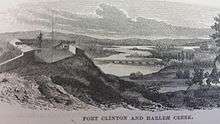
Fort Clinton in New York City's Central Park was an 1814 stone-and-earthworks fortification on a rocky escarpment near the present line of 107th Street, slightly west of Fifth Avenue. According to maps of the time, Fort Clinton was the easternmost of a connected series of forts, connected to Nutter's Battery on the west by earthworks and a gatehouse over the Old Post Road at the bottom of McGowan's Pass.[2] Fort Clinton and Nutter's Battery were commanded from a third fort at the top of the Pass, Fort Fish, which had a sweeping view of Long Island Sound, northern Manhattan, and Westchester County. Fish was across the road from Clinton and connected to Nutter's Battery by another line of earthworks.[3][4]
According to the Central Park Conservancy's website, the fort was named after New York City's mayor, DeWitt Clinton.[5] During the American Revolution, the site was used by the British and Hessians during their occupation of New York City, 1776–1783.
References
- 1 2 Lossing, Benson (1868). The Pictorial Field-Book of the War of 1812. Harper & Brothers, Publishers. p. 972.
- ↑ "Northern Forts" page at michaelminn.net has a detail of a contemporary map.
- ↑ Edward Hagaman Hall, McGown's Pass and Its Vicinity, 1905.
- ↑ I. N. Phelps Stokes, The Iconography of Manhattan Island, 1928.
- ↑ CPC site here.