Fort Beauséjour
| Fort Beauséjour | |
|---|---|
| Aulac, New Brunswick | |
|
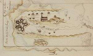
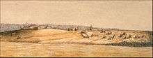
Fort Beauséjour and Cathedral (c. 1755) | |
| Type | Fortress |
| Site information | |
| Controlled by |
France (1751-1755), United Kingdom (1755-1835), Parks Canada (1926-present) |
| Official name | Fort Beauséjour – Fort Cumberland National Historic Site of Canada |
| Designated | 1920 |
| Site history | |
| Built | 1751 |
| In use | 1751-1835 |
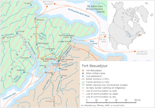
Coordinates: 45°51′52.49″N 64°17′29.62″W / 45.8645806°N 64.2915611°WFort Beauséjour (French pronunciation: [fɔʁ boseˈʒuːʁ]) was a large five-star fort on the Isthmus of Chignecto, a neck of land connecting present-day New Brunswick with Nova Scotia, Canada. The site was strategically important in Acadia, a French colony that included parts of what is now Quebec, The Maritimes, and northern Maine. It was built by the French from 1751 to 1752. It was surrendered to the British in 1755 after the Battle of Fort Beauséjour and renamed Fort Cumberland. The fort played an important role in the Anglo-French rivalry of 1749-63 and in the 1776 Battle of Fort Cumberland when sympathisers of the American Revolution were repulsed.
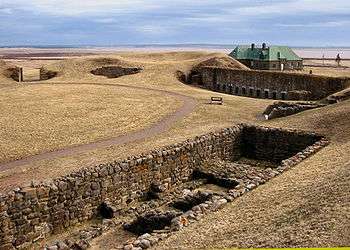
Today the site is a National Historic Site of Canada, named the Fort Beauséjour – Fort Cumberland National Historic Site. Portions of the fort have been restored.[1] A museum at the site depicts the conflicts between France and Britain in the 1700s, and the later struggle between America and Britain.[2] The site sees about 6000 visitors each year.[3]
Historical context
During the 1600s and 1700s, European monarchies were almost permanently at war with each other. The threat of Anglo-American invasion of New France was constant, and Acadia was particularly vulnerable.[4] Its capital, Port Royal, was founded in 1605, destroyed by the British in 1613, moved upstream in 1632, besieged in 1707, and finally taken in the Siege of Port Royal (1710). Under the terms of the 1713 Treaty of Utrecht, the Kingdom of France had ceded to the Kingdom of Great Britain the territory known today as mainland Nova Scotia. The treaty stated that France retained control of Île-Royale, now Prince Edward Island and Cape Breton. France's colony Canada extended from what is now Quebec to the Gaspé Peninsula. The treaty of Utrecht left it unclear who had sovereignty over the land between Gaspesie and Nova Scotia, now New Brunswick, and where the western border of Nova Scotia stood. The de facto border became the Isthmus of Chignecto at the Missiguash River, site of the prosperous Acadian settlement Beaubassin.
In the mid-1700s France and Britain were about to clash worldwide and in North America in the Seven Years' War. In the middle of the 1700s, over one million British colonists occupied a limited area along the Atlantic coast, while in the European population of what is now The Maritimes was 18,544,[5] part of a total New France population of 70,000.[6]
Fort Beauséjour
As tensions escalated, in 1749 British fortifications were erected in Nova Scotia at Citadel Hill, Halifax, and Fort Sackville, Bedford, while the French rebuilt the Fortress of Louisbourg, and re-occupied Fort Nerepis.
In 1750 the French added to the military personnel in their colony.[7] In April of that year Governor Edward Cornwallis sent British Major Charles Lawrence with a small force to establish British authority in the isthmus of Chignecto. On the north bank of the Missaguash River Lawrence found French forces under Louis de La Corne, who had orders to prevent British advancement beyond that point and had the village of Beaubassin burned. Rather than fight the French, with whom the British were not at war, or admit to any territorial limitation, Lawrence withdrew.[8]
There was not agreement in London as to how far troops should go in establishing claims during a time of peace. However, Lawrence was eventually sent to the Missaguash River with a stronger force and routed a group of Indians led by Father Le Loutre, a French agent provocateur. In the autumn of 1750 Lawrence built Fort Lawrence near the site of the ruined village of Beaubassin.[8]
In November 1750 Governor General de la Jonquière ordered that two forts be built at either end of the Isthmus of Chignecto to block the British, one being Fort Gaspareaux on the Northumberland Strait and the other Fort Beauséjour on the Bay of Fundy.
Construction began in April 1751 under the direction of Lieutenant Gaspard-Joseph Chaussegros de Léry.[9] By 1751 the gunpowder magazine, a well, four casemates, and officers' quarters were finished. The barracks, were added the following year.[10] By 1753 the fort had palisade walls and a five metre high earthwork. It was a pentagon shaped star fort with bastions built of earth and pickets at the corners.[9]
In 1754, Louis Du Pont Duchambon de Vergor became the commander of Fort Beausejour. Events eventually revealed that he was unfit for military command. Louis-Léonard Aumasson de Courville, who became Vergor’s secretary at Beauséjour claimed that Vergor was “avaricious in the extreme,” and in his memoirs is a quotation attributed to François Bigot: “Profit, my dear Vergor, by your opportunity [at Beauséjour]; trim, – cut – you have the power – in order that you may soon join me in France and purchase an estate near me.”[11]
Battle of Fort Beauséjour
The French position may have been undermined by Thomas Pichon, a clerk at the fort. The British commandant at Fort Lawrence paid Pichon for information about French activities. Pichon provided accounts of French activities, plans of forts and an outline of the steps necessary for capture, which Lieutenant-Colonel Robert Monckton later used in the attacks. Pichon delayed the strengthening of Beauséjour by advising that the British would not attack that year.[12]
A convoy of 31 transports and three warships left Boston on 19 May 1755, carrying nearly 2,000 New England provincial troops and 270 British regulars, and dropped anchor near the mouth of the Missaguash River on 2 June.[13] The next day the troops, under the command of Lieutenant-Colonel Robert Monckton of the regular army, disembarked a few kilometres from Fort Beauséjour. To defend the fort, Commander Louis Du Pont Duchambon de Vergor had only 150 soldiers from the Compagnies franches de la Marine and a dozen canonniers-bombardiers. On 16 June 16, a large English bomb went through the roof of a casemate and killed many of its occupants. Vergor laid down his weapons. The fort was surrendered, and renamed Fort Cumberland. The next day Fort Gaspereau was surrendered without being attacked. The fall of these forts settled the boundary dispute in favour of the British and marked the beginning of the Expulsion of the Acadians.[11]
The minister of Marine, Machault, had good reason to believe the forts had been “very ill defended” and Vergor was summoned before a court martial at Quebec in September 1757 but was acquitted.[11]
Fort Cumberland
In the months following the fort's capture, British forces ordered Acadians living in the region to sign an oath of allegiance to the British Crown. However, the Acadians refused, preferring to remain neutral. Some Acadians reported that they had been coerced into assisting in the defense of Fort Beauséjour, and the British used this as a reason to begin the Expulsion of the Acadians. Acadian homes were burnt to prevent their return. As the British army had relocated to Fort Cumberland, they abandoned and burned Fort Lawrence in October 1756. Fort Cumberland became one of the sites in which the British imprisoned or temporarily held Acadians during the nine years of the expulsion, the others being Fort Edward (Nova Scotia); Fort Frederick, Saint John, New Brunswick, and Fort Charlotte, Georges Island, Halifax.
Under the leadership of French officer Boishébert, Acadians and Mi'kmaq fought the expulsion from their homeland. In the early spring of 1756, a band of Acadian and Mi'kmaq partisans ambushed a small party of New England soldiers' cutting wood for Fort Cumberland, killing and mutilating nine men.[14] In April 1757, after raiding Fort Edward, a band of Acadian and Mi'kmaq partisans also raided Fort Cumberland, killing and scalping two men and taking two prisoners.[14] In July Mi'kmaq captured two of Gorham's rangers outside Fort Cumberland.[15] In March 1758, forty Acadian and Mi'kmaq attacked a schooner at Fort Cumberland and killed its master and two sailors.[15] In the winter of 1759, five British soldiers on patrol were ambushed while crossing a bridge near Fort Cumberland. They were scalped and their bodies were mutilated as was common in frontier warfare.[14] In October 1761, commander of the fort Roderick McKenzie of the Montgomery's Highlanders went to Bay of Chaleurs to remove the 787 Acadians. He captured 335.
In 1776, early in American Revolutionary War, Fort Cumberland and its garrison of the Royal Fencible American Regiment repelled several rebel attacks in the Battle of Fort Cumberland from local guerrillas led by the American sympathizer Jonathan Eddy.
Fort Cumberland was abandoned in the late 1780s. With the British resumption of the War of 1812 with the United States, British forces reoccupied and refurbished the fort, although it did not see any action during this conflict. The British military in 1835 declared the fort surplus property and it was abandoned.
See also
References
- ↑ Fort Beauséjour – Fort Cumberland National Historic Site of Canada, Parks Canada
- ↑ Canada, Parks Canada Agency, Government of. "Parks Canada - Fort Beauséjour – Fort Cumberland National Historic Site". www.pc.gc.ca. Retrieved 2016-01-24.
- ↑ "Fort Beausejour-Fort Cumberland saw more visitors in 2015 - Local - Cumberland News Now". www.cumberlandnewsnow.com. Retrieved 2016-01-27.
- ↑ "Wars and Imperial Rivalries | Virtual Museum of New France". www.historymuseum.ca. Retrieved 2016-01-27.
- ↑ "Censuses of Canada 1665 to 1871: Estimated population of Canada, 1605 to present". www.statcan.gc.ca. Retrieved 2016-01-26.
- ↑ "New France Map 1750 Information Page". www.worldatlas.com. Retrieved 2016-01-26.
- ↑ Chartrand, René. "The French Garrison". www.cmhg.gc.ca. Retrieved 2016-01-26.
- 1 2 "Biography – LAWRENCE, CHARLES – Volume III (1741-1770) – Dictionary of Canadian Biography". www.biographi.ca. Retrieved 2016-01-26.
- 1 2 Brun, Régis; Johnston, AJB; Clarke, Ernest. Fort Beauséjour - Fort Cumberland A History. Societé du Monument Lefebvre. Retrieved 24 January 2016.
- ↑ Chartrand, René (2008-01-01). The Forts of New France in Northeast America 1600-1763. Osprey Publishing. ISBN 9781846032554.
- 1 2 3 "Biography – DU PONT DUCHAMBON DE VERGOR, LOUIS – Volume IV (1771-1800) – Dictionary of Canadian Biography". www.biographi.ca. Retrieved 2016-01-26.
- ↑ "Biography – PICHON, THOMAS, Thomas Tyrell – Volume IV (1771-1800) – Dictionary of Canadian Biography". www.biographi.ca. Retrieved 2016-01-25.
- ↑ "Biography – MONCKTON, ROBERT – Volume IV (1771-1800) – Dictionary of Canadian Biography". www.biographi.ca. Retrieved 2016-01-25.
- 1 2 3 Faragher, John Mack (2005). A great and noble scheme : the tragic story of the expulsion of the French Acadians from their American Homeland (1st ed.). New York: W.W Norton & Company. pp. 271–410. ISBN 978-0393328271.
- 1 2 Grenier, John (2008). The far reaches of empire : war in Nova Scotia, 1710-1760. Norman: University of Oklahoma Press. pp. 179–195. ISBN 978-0806138763.
Further reading
| Wikimedia Commons has media related to Fort Beauséjour. |
- Jeremiah Bancroft kept a diary in which he gives an account of the fall of Fort Beausejour and the Expulsion of the Acadians at Grand-Pré, Nova Scotia.[1]
| Year list (Timeline) | |
|---|---|
| Topics | |
| Provinces & territories | |
| Cities | |
| Research | |
| |
| Provinces | |
|---|---|
| Territories | |
| Other countries | |
| |
- ↑ Jonathan Fowler and Earle Lockerby (2009). Operations at Fort Beausejour and Grande Pre in 1755: A soldier's diary. The Royal Nova Scotia Historical Society Journal pp.145-184