Fort Atkinson, Iowa
| Fort Atkinson, Iowa | |
|---|---|
| City | |
|
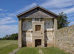
Ruins of historic Fort Atkinson | |
 Location of Fort Atkinson, Iowa | |
| Coordinates: 43°8′39″N 91°56′5″W / 43.14417°N 91.93472°WCoordinates: 43°8′39″N 91°56′5″W / 43.14417°N 91.93472°W | |
| Country | United States |
| State | Iowa |
| County | Winneshiek |
| Area[1] | |
| • Total | 0.31 sq mi (0.80 km2) |
| • Land | 0.31 sq mi (0.80 km2) |
| • Water | 0 sq mi (0 km2) |
| Elevation | 1,047 ft (319 m) |
| Population (2010)[2] | |
| • Total | 349 |
| • Estimate (2012[3]) | 343 |
| • Density | 1,125.8/sq mi (434.7/km2) |
| Time zone | Central (CST) (UTC-6) |
| • Summer (DST) | CDT (UTC-5) |
| ZIP code | 52144 |
| Area code(s) | 563 |
| FIPS code | 19-28425 |
| GNIS feature ID | 0456681 |
Fort Atkinson is a city in Winneshiek County, Iowa, United States. The population was 349 at the 2010 census. It is home to the historic Fort Atkinson State Preserve and hosts a large annual fur-trapper rendezvous each September.[4] Fort Atkinson holds the largest regional hay auction every Wednesday.[5]
History
Fort Atkinson was built to protect the Ho-Chunk (Winnebago) during their removal from Wisconsin. The name honors Henry Atkinson, the commanding officer in charge of the effort. Construction began in May 1840 and was complete by the summer of 1842. The regular army turned the fort over to Iowa volunteers as the troops stationed there were needed for the Mexican-American War. After the Ho-Chunk were removed from Iowa the post was abandoned on February 14, 1849.[6]
Geography
Fort Atkinson is located at 43°8′39″N 91°56′5″W / 43.14417°N 91.93472°W (43.144034, -91.934839).[7]
According to the United States Census Bureau, the city has a total area of 0.31 square miles (0.80 km2), all of it land.[1]
Demographics
| Historical populations | ||
|---|---|---|
| Year | Pop. | ±% |
| 1880 | 435 | — |
| 1890 | 480 | +10.3% |
| 1900 | 264 | −45.0% |
| 1910 | 289 | +9.5% |
| 1920 | 315 | +9.0% |
| 1930 | 305 | −3.2% |
| 1940 | 261 | −14.4% |
| 1950 | 273 | +4.6% |
| 1960 | 353 | +29.3% |
| 1970 | 339 | −4.0% |
| 1980 | 374 | +10.3% |
| 1990 | 367 | −1.9% |
| 2000 | 389 | +6.0% |
| 2010 | 349 | −10.3% |
| 2014 | 337 | −3.4% |
| 2015 | 336 | −0.3% |
| Source:"American FactFinder". United States Census Bureau. and Iowa Data Center Source: | ||
2010 census
As of the census[2] of 2010, there were 349 people, 160 households, and 102 families residing in the city. The population density was 1,125.8 inhabitants per square mile (434.7/km2). There were 170 housing units at an average density of 548.4 per square mile (211.7/km2). The racial makeup of the city was 98.0% White, 1.7% from other races, and 0.3% from two or more races. Hispanic or Latino of any race were 3.2% of the population.
There were 160 households of which 22.5% had children under the age of 18 living with them, 46.9% were married couples living together, 11.9% had a female householder with no husband present, 5.0% had a male householder with no wife present, and 36.3% were non-families. 34.4% of all households were made up of individuals and 20% had someone living alone who was 65 years of age or older. The average household size was 2.18 and the average family size was 2.78.
The median age in the city was 47.3 years. 20.3% of residents were under the age of 18; 8.7% were between the ages of 18 and 24; 18.4% were from 25 to 44; 27.5% were from 45 to 64; and 25.2% were 65 years of age or older. The gender makeup of the city was 49.6% male and 50.4% female.
2000 census
As of the census[9] of 2000, there were 389 people, 165 households, and 102 families residing in the city. The population density was 1,240.9 people per square mile (484.5/km²). There were 169 housing units at an average density of 539.1 per square mile (210.5/km²). The racial makeup of the city was 99.49% White, 0.26% Native American and 0.26% Asian. Hispanic or Latino of any race were 0.26% of the population.
There were 165 households out of which 26.1% had children under the age of 18 living with them, 53.3% were married couples living together, 7.9% had a female householder with no husband present, and 37.6% were non-families. 33.9% of all households were made up of individuals and 18.8% had someone living alone who was 65 years of age or older. The average household size was 2.36 and the average family size was 3.05.
In the city the population was spread out with 26.0% under the age of 18, 8.2% from 18 to 24, 23.7% from 25 to 44, 21.6% from 45 to 64, and 20.6% who were 65 years of age or older. The median age was 40 years. For every 100 females there were 95.5 males. For every 100 females age 18 and over, there were 101.4 males.
The median income for a household in the city was $34,205, and the median income for a family was $38,333. Males had a median income of $27,292 versus $17,813 for females. The per capita income for the city was $14,702. About 12.3% of families and 12.7% of the population were below the poverty line, including 9.6% of those under age 18 and 12.7% of those age 65 or over.
City government
Fort Atkinson is governed by Mayor Paul Herold and a city council composed of David Bullgreen, Michelle Elsbernd, Dave Schneider, and Kay Schmitt.
Schools
Fort Atkinson is located in the Turkey Valley School District, a small K-12 school with about 575 students. There is also a private Catholic school in Protivin called Trinity Catholic School. The district's schools serve students from the small communities of Little Turkey, Lawler, Waucoma, St. Lucas, Protivin, Fort Atkinson, and Jackson Junction. The schools themselves are located in Jackson Junction.
References
- 1 2 "US Gazetteer files 2010". United States Census Bureau. Retrieved 2012-05-11.
- 1 2 "American FactFinder". United States Census Bureau. Retrieved 2012-05-11.
- ↑ "Population Estimates". United States Census Bureau. Retrieved 2013-05-23.
- ↑ Iowa DNR, http://www.iowadnr.gov/parks/state_park_list/fort_atkinson.html
- ↑ Farm Industry News, http://farmindustrynews.com/jeffryan/0629-jeff-ryan-column/
- ↑ Carr, Jeffrey T.; William E. Whittaker (2009). "Fort Atkinson, Iowa, 1840-1849". In W.E. Whittaker. Frontier Forts of Iowa: Indians, Traders, and Soldiers, 1682-1862. Iowa City, Iowa: University of Iowa Press. pp. 146–160. ISBN 978-1-58729-831-8.
- ↑ "US Gazetteer files: 2010, 2000, and 1990". United States Census Bureau. 2011-02-12. Retrieved 2011-04-23.
- ↑ "Census of Population and Housing". Census.gov. Retrieved June 4, 2015.
- ↑ "American FactFinder". United States Census Bureau. Retrieved 2008-01-31.
Municipalities and communities of Winneshiek County, Iowa, United States | ||
|---|---|---|
| Cities | ||
| Townships | ||
| CDP | ||
| Unincorporated community | ||
| Ghost town | ||