Forst (Lausitz)
| Forst (Lausitz) | |||
|---|---|---|---|
|
Watertower in Forst | |||
| |||
 Forst (Lausitz) | |||
Location of Forst (Lausitz) within Spree-Neiße district _in_SPN.png) | |||
| Coordinates: 51°44′N 14°38′E / 51.733°N 14.633°ECoordinates: 51°44′N 14°38′E / 51.733°N 14.633°E | |||
| Country | Germany | ||
| State | Brandenburg | ||
| District | Spree-Neiße | ||
| Government | |||
| • Mayor | Philipp Wesemann (SPD) | ||
| Area | |||
| • Total | 109.91 km2 (42.44 sq mi) | ||
| Population (2015-12-31)[1] | |||
| • Total | 18,773 | ||
| • Density | 170/km2 (440/sq mi) | ||
| Time zone | CET/CEST (UTC+1/+2) | ||
| Postal codes | 03141–03149 | ||
| Dialling codes | 03562 | ||
| Vehicle registration | SPN | ||
| Website | www.forst-lausitz.de | ||

.svg.png)
.svg.png)
Forst (Lausitz) (Lower Sorbian: Baršć) is a town in Brandenburg, Germany. It lies east of Cottbus, on the river Lausitzer Neiße which is also the German-Polish border, the Oder-Neisse line. It is the capital of the Spree-Neiße district. It is known for its rose garden and textile museum. The town's population is 20,618. In Forst, there is a railway bridge across the Neiße belonging to the line Cottbus–Żary which is serviced by regional trains and a EuroCity train between Hamburg and Kraków (2011). There is also a road bridge across the river north of Forst.
Overview
Part of the region of Lusatia, Forst was awarded to the Kingdom of Prussia in the 1815 Congress of Vienna. The town was subsequently administered within the Province of Brandenburg. After World War II it became part of the German Democratic Republic.
Forst has experienced severe problems as a result of the 1990 German reunification, most notably from extreme unemployment. In the past, the town was known for textile manufacturing, but all of the textile plants and factories have closed down in recent years.
History
A short distance to the south of the old Sorbian village of Altforst, the town probably originated around 1150 at a river crossing point on the important west-east route (known as the Salzstraße / Salt Road) connecting Halle and Głogów. By 1265 it was developing into a permanent trading settlement round the Church of St Nicholas. The commercial importance of Forst increased with the development of a north-south route connecting to Guben, downstream along the Neisse River. In the fourteenth century the council was able to take on responsibility for the lower courts locally. In 1352 of Ileburg took over the overlordship of Forst from Frederick III of Meißen.
Demography
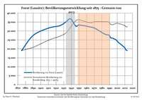 Development of Population since 1875 within the Current Boundaries (Blue Line: Population; Dotted Line: Comparison to Population Development of Brandenburg state; Grey Background: Time of Nazi rule; Red Background: Time of Communist rule)
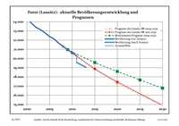 Recent Population Development (Blue Line) and Forecasts
|
|
|
|
Detailed data sources are to be found in the Wikimedia Commons.[3]
People
- Hugo Baum (1867 - 1950), botanist
- Georg Thomas (1890–1946), general of infantry
- Bruno Kastner (1890–1932), film and stage actor
- Max Seydewitz (1892–1987), politician (SPD, SED)
- Brigitte Frank, née Herbst (1895–1959), wife of Hans Frank
- Erich Neumann (1892–1948), politician (NSDAP)
- Werner Heyde (1902–1964), psychiatrist, involved in the T 4 programm
- Georg Bose (1921–2011), German officer during World War II,
- Günter Nooke (born 1959), politician (CDU)
- René Rydlewicz (born 1973), footballer
- Ronny Scholz (born 1978), cyclist
References
- ↑ "Bevölkerung im Land Brandenburg nach amtsfreien Gemeinden, Ämtern und Gemeinden 31. Dezember 2015 (Fortgeschriebene amtliche Einwohnerzahlen auf Grundlage des Zensus 2011)". Amt für Statistik Berlin-Brandenburg (in German). 2016.
- ↑ Boundaries as of 2013
- ↑ Population Projection Brandenburg at Wikimedia Commons
External links
-
 Media related to Forst (Lausitz) at Wikimedia Commons
 - Official website of Forst (Lausitz) (German)
- Forst's Rose Garden (German)
-
 "Forst". Encyclopædia Britannica (11th ed.). 1911.
 - "Forst". New International Encyclopedia. 1905.