Forrest Place

Forrest Place is a pedestrianised square located within the CBD of Perth, Western Australia. The street was created in 1923, and has a history of being a focal point for significant political meetings and demonstrations.
Description
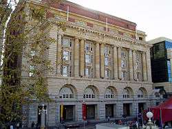
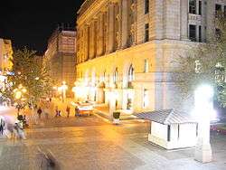
Forrest Place connects Perth Railway Station on Wellington Street with the Murray Street Mall, outside the Carillon City shopping centre. It is 150 metres (490 ft) long,[3] and is paved and landscaped as a pedestrian mall, with seating, public artwork, and trees. The eastern side of the street is lined by shops from the Forrest Chase shopping complex, while the historic General Post Office and Commonwealth Bank buildings are located to the west.[3]
Forrest Place is used in many ways throughout the year, including cultural displays, children's activities and parades, and contains the City of Perth visitors centre.[4]
Nearby transport facilities include Perth railway station and Wellington Street bus station, and Perth Central Area Transit (CAT) buses run along Wellington Street,
History
Named after Sir John Forrest, the first Premier of Western Australia, Forrest Place was for most of its history a roadway between the Perth railway station and Murray Street.
It was originally a plot of land issued to Patrick Farmer in 1840. Prior to Forrest Place's construction, an arcade between Wellington and Murray Streets existed on the site known as Central Arcade. It was considered an "unhealthy" establishment, which led to its demolition. The construction of Forrest Place deemed to have "changed the face of Perth".[1]
Streetscape
Prior to the building of the Forrest Chase complex (containing Myer and numerous other retail stores), the central building on the eastern side of Forrest Place was the Padbury Buildings (built in 1925[5] and demolished in 1986–1987). While the buildings on the east side have changed a number of times in the street's 82-year history, the General Post Office (completed in 1923[6]) and the Commonwealth Bank building (completed 1933[2]), both designed by John Smith Murdoch in the Interwar Beaux-Arts style and faced with Donnybrook stone, have endured significant change around them.
Parades, meetings and rallying place
In the 1940s returned soldiers marched through Forrest Place.[7]
It was a meeting place and focal point for political meetings in the 1950s through to the 1980s;[8] considerable use was made of the steps of the Post Office being above the roadway level.
An attempt to defuse the political nature of the space and ban meetings in Forrest Place was carried out by Charles Court, on 18 November 1975, when his government used Section 54B of the Western Australia Police Act to ban meetings.[9] Considerable numbers of demonstrations resulted from this ban, which was later repealed by the Public Meetings and Processions Act of 1984.
In 2013, the history of protests held at Forest Place, and the responses by authorities, was the subject of a presentation by Murdoch University Adjunct Associate Professor Lenore Layman. These events are considered by Layman to be part of an "alternative history of Perth" that isn't so sedated.[10]
Pedestrian mall

Forrest Place became a large paved area with the closing of the roadway in the late 1987.[11] It still links Wellington Street and Perth railway station with the Murray Street Mall, with the placement of the "Grow Your Own" public artwork limiting vehicular access to the north.

See also
![]() Australian Roads portal
Australian Roads portal
References
- 1 2 3 "Postal palace - the new G.P.O. ready at last". The West Australian. Perth, Western Australia. 26 September 1923. Archived from the original (JPG) on 31 July 2008. Retrieved 18 July 2008.
- 1 2 "Commonwealth Bank Building" (PDF). Heritage Council of Western Australia. Retrieved 31 July 2006.
- 1 2 Google (8 December 2013). "Forrest Place" (Map). Google Maps. Google. Retrieved 8 December 2013.
- ↑ "Forrest Place". City of Perth. Retrieved 31 July 2006.
- ↑ "Padbury Buildings". Heritage Council of Western Australia. Retrieved 31 July 2006.
- ↑ "General Post Office" (PDF). Heritage Council of Western Australia. Retrieved 31 July 2006.
- ↑ Edmonds, Jack (editor) (1976) Swan River colony : life in Western Australia since the early colonial settlement, illustrated by pictures from an exhibition mounted by West Australian Newspapers Ltd. as a contribution to celebrations for the state's 150th year Perth : West Australian Newspapers, 1979.ISBN 0909699208 - page 79 - Ninth Division troops 24 March 1943
- ↑ Edmonds, Jack (editor) (1976) Swan River colony : life in Western Australia since the early colonial settlement, illustrated by pictures from an exhibition mounted by West Australian Newspapers Ltd. as a contribution to celebrations for the state's 150th year Perth : West Australian Newspapers, 1979.ISBN 0909699208 - page 95 - Gough Whitlam - 1974,
- ↑ 54B affects you!, Civil Liberties Action Committee, 1980, retrieved 8 December 2013
- ↑ http://community.perth.wa.gov.au/historycentre/?page_id=1994 Forrest Place: A civic space of protest? - the summary of the presentation was given as: "A presentation by Adjunct Associate Professor Lenore Layman - Forrest Place has often been a contested city space as citizens have chosen the site to exercise their right to peaceful public protest. People's causes have been many and varied but always passionately proclaimed; and public authorities have frequently responded decisively to re-assert control of the street. Together the protests and responses to them tell part of an alternative history of Perth. Perhaps the city hasn't been so sedate after all?"
- ↑ Photo WA Library collect 1987 demolition
Further reading
- Conole, Peter.(2002) Protect & serve : a history of policing in Western Australia Scarborough, W.A. : Western Australian Police Historical Society. ISBN 0-9579535-2-6 - see specially pp. 343–348 regarding the problems of 54B for the police service.
- Gregory, Jenny. (2003) City of light: a history of Perth since the 1950s Perth, W.A.: City of Perth ISBN 0-9594632-4-0 - see specially pp. 124–130 concerning the political history of the space.
Original title and later map of site
- Mason, John. Title of Perth town lot V 17, 1840 Issued in his name, 3 Nov. 1840. (Mason, John—Archives - Battye Library)
- Australia. Dept. of the Interior.(1911) Perth new G.P.O. site: Plan of existing buildings. Plan Nos. D663 and D664.(Signed by Hillton Beasley, Chief Architect). (Australian Archives)
External links
![]() Media related to Forrest Place at Wikimedia Commons
Media related to Forrest Place at Wikimedia Commons
- Photographs of Forrest Place, State Library of Western Australia
- Photographs of the Padbury Buildings, State Library of Western Australia